
The city's front porch on the water
The Wharf is a mile-long waterfront district on the Southwest Waterfront of Washington, D.C., running along the eastern bank of the Washington Channel — the arm of the Potomac River that separates the city from East Potomac Park — from the Francis Case Memorial Bridge in the north to Fort McNair in the south. It is the District's most deliberate attempt to give itself what it never quite had: a waterfront you can walk. There are four public piers, a mile of promenade, a marina, parks, hotels, apartments, offices, restaurants, and three live-music venues, all of it built on 24 acres of land and 50 acres of water, with some 3.2 million square feet of buildings. The promenade and the piers are open to everyone, free, and they are the point: this is a neighborhood designed to be walked through, not driven past.
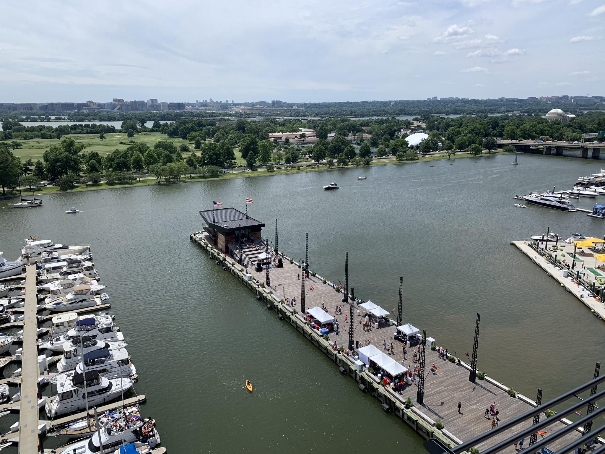
Stand on the District Pier at dusk and the city rearranges itself. Across the channel, East Potomac Park is a dark green strip, and beyond it the Jefferson Memorial's dome catches the last light. Behind you, the glass towers of the new Wharf glow along Wharf Street. Below you, the marina rocks gently, and a water taxi slides past toward Alexandria. It is hard to believe that for most of the twentieth century this stretch of water was cut off from the city by highways and parking lots, and that the neighborhood behind it was once erased almost entirely. The Wharf's story is really three stories stacked on top of each other: a working waterfront that began in 1805, a neighborhood that was demolished in the 1950s, and a new district that was built, very deliberately, on top of both.
The name itself is a piece of recovered history. The developers — Hoffman & Associates and Madison Marquette, working together as Hoffman-Madison Waterfront — named the project at the suggestion of D.C. Congresswoman Eleanor Holmes Norton, who recalled that this stretch of the Southwest Waterfront had been known as "the Wharf" in the nineteenth and early twentieth centuries. The name stuck because it was true: before it was a development, the Wharf was a place where boats tied up and fish changed hands.
A working waterfront since 1805
Washington was a river city before it was a capital of monuments. The Southwest Waterfront was the city's working edge from the beginning: a seaport where Chesapeake Bay watermen brought their catch up the Potomac, where steamboats stopped from 1815, and where oyster and fish houses lined the docks. The city's first military post was established here in 1791 on Greenleaf's Point, where the Anacostia and Potomac rivers meet — today Fort Lesley J. McNair, which still anchors the southern end of the waterfront. By 1900 the neighborhood behind the docks was fully built and densely populated, a working-class community of some 35,000 people living in Victorian row houses and alley dwellings within a few blocks of the water.
The street that fronted the market tells the story in miniature. It was Water Street SW for more than a century, and it was renamed Maine Avenue in 1938. The fish trade was so central to the waterfront that in 1823 Congress designated part of it as "fish-docks" — the only place in the District where fish could legally be sold from a boat. The waterfront was not picturesque in the way visitors imagine it now. It was loud, muddy, and commercial: wagons, barges, ice houses, and the smell of the catch. It was also, for generations of Washingtonians, simply where dinner came from.
The market that would not leave
At the northern end of the Wharf, at 1100 Maine Avenue SW, sits the reason the whole district still feels like a real place: the Municipal Fish Market, also known as the Maine Avenue Fish Market. Opened in 1805, it is the oldest continuously operating open-air fish market in the United States — seventeen years older than New York City's Fulton Fish Market, which opened in 1822 and moved to the Bronx in 2005. When the market first opened, Thomas Jefferson had just begun his second term as president, and local fishing boats were selling their catch from the docks along the Washington Channel.
The market has survived by refusing to be a building. Its vendors have always sold from floating barges and open stalls, and that impermanence turned out to be its protection. A brick Municipal Fish Market building, designed by Snowden Ashford, was built in 1918 and stood for more than forty years — but when the wrecking crews of urban renewal came for the waterfront in 1960, the building went and the vendors did not. The market was relocated a few blocks from its original site, and the vendors exercised a clause in their leases allowing them to stay for 99 years. The stalls you see today — Captain White's Seafood City, Jessie Taylor Seafood, and their neighbors, with their hand-painted signs advertising shrimp, lobster, and jumbo crabs — are the direct descendants of the fish houses of 1805. The market's barges still float in the channel, and on a Friday evening through Sunday the selection is at its widest, with blue crabs — the signature catch of the nearby Chesapeake Bay — piled in steel bins and steamed to order.
The Wharf's developers understood what they had. The redevelopment did not replace the market; it built around it, gave it a renovated home at Market Square, and made it the district's anchor. A historical marker at Maine Avenue and Market Square states the fact plainly: opened in 1805, the oldest continuously operating fish market in the United States. It is the one institution on the waterfront that predates everything else by more than two centuries, and it is still doing the same job it did when Jefferson was president.
The bulldozers: Southwest's urban renewal
The second story of the Wharf is the hardest one, and it is the reason the waterfront spent half a century cut off from the city. In 1945, Congress passed the District of Columbia Redevelopment Act, creating the Redevelopment Land Agency and handing it the power of eminent domain. In 1950, the National Capital Park and Planning Commission's comprehensive plan identified Southwest as a "problem area" in need of redevelopment. By the end of 1952, the first urban renewal plan for Southwest — designated "Area B" — had been approved. In late 1953, the agency began acquiring property, and relocation started shortly thereafter.
Demolition began in the spring of 1954. Over roughly two decades, about 4,800 structures across 560 acres were leveled. Some 23,000 residents — nearly 6,000 families — were displaced, along with roughly 1,500 businesses. Ninety-nine percent of the buildings in Southwest were demolished. The great majority of those displaced were Black Washingtonians, many of them descendants of families who had moved to the neighborhood after the Civil War for the industrial jobs along the Potomac. A 1966 study found that a quarter of the people who were moved never made a single friend in their new neighborhood. The legal challenge to the whole program, Berman v. Parker, reached the Supreme Court in 1954, and the justices ruled 8 to 0 for the government, giving it sweeping authority to condemn entire neighborhoods for redevelopment.
What replaced Old Southwest was admired at the time as a "new town in the city": modernist towers, townhouses, and superblocks, including the Capitol Park apartments and the federal office buildings around L'Enfant Plaza. Most of the construction was complete by 1970. But the waterfront itself was left behind. The mile of shore along the Washington Channel became a strip of low, one-to-three-story commercial buildings — large-format restaurants, a motel, parking lots — set apart from the rest of the city by highways and emptiness. The fish market survived, the marina survived, and almost nothing else did. For close to fifty years, the Southwest Waterfront was the part of the capital that Washington forgot.
The long wait and the new Wharf
The idea of redeveloping the waterfront gained momentum in the early 2000s, when the Anacostia Waterfront Corporation was created to oversee the Southwest Waterfront's renewal. The goal was to reconnect the neglected, isolated southwest quadrant with downtown Washington and make the area accessible and attractive to pedestrians, while keeping the existing community — the market, the marina, the people who lived on their boats — in place. In 2010, Hoffman & Associates partnered with Madison Marquette and formed Hoffman-Madison Waterfront to bring the project to fruition. The firm Perkins Eastman was hired as the master architect and master planner, and in March 2013 the D.C. Zoning Commission approved plans for the project's two phases.
Groundbreaking for Phase 1 took place on May 19, 2014. The Wharf opened to the public on October 12, 2017, delivering a mix of residential, retail, office, maritime, and entertainment space: more than 800 apartments, three hotels, three office buildings, restaurants, shops, waterfront parks, promenades, and four public piers. In 2019, Phase 1 won the Urban Land Institute's Global Award for Excellence. Groundbreaking for Phase 2 followed in March 2019, and it opened on October 12, 2022 — the fifth anniversary of Phase 1 — completing the district at a total redevelopment cost of $3.6 billion. Phase 2 added 255 apartments, 96 condominiums, 131 hotel rooms, more than 570,000 square feet of office space, over 100,000 square feet of retail, a 1.5-acre park called The Green connecting the waterfront to Maine Avenue, 223 boat slips at the Wharf Marina, and two garages with more than 1,000 parking spaces. The entire Wharf is LEED Gold certified. In 2025, Hoffman and Madison Marquette sold their stake in the development to PSP Investments, the Public Sector Pension Investment Board, which became its sole owner.
The architecture is deliberately industrial in its references: brick, steel, glass, and exposed structure, a nod to the warehouses and fish houses that used to stand here. The buildings are new, but the street names and the market and the marina are old, and that tension is the district's character. The Wharf is not a restoration — almost nothing here is original — but it is a return: a return of the city to a stretch of water it had abandoned.
The Anthem and the piers
The Wharf's loudest room is The Anthem, the 57,000-square-foot concert venue at 901 Wharf Street SW, at the base of The Channel apartment building. It opened on October 12, 2017 — the same day as Phase 1 — with a show opened by The Struts and headlined by the Foo Fighters. Operated by I.M.P., the company behind Washington's 9:30 Club, the venue has a movable stage and backdrop that lets its capacity flex from 2,500 to 6,000, and it was the first venue of its size in the District built from the ground up for music. Its industrial design, by the Rockwell Group with programming by David M. Schwarz Architects, takes its cues from the waterfront's working past. Two smaller club venues fill out the district's music scene on the entertainment-focused Pearl Street: Union Stage, a 450-person venue, and Pearl Street Warehouse, a 300-person bar and live-music room.
The piers are the district's public rooms, and each one has a job. The District Pier extends 425 feet into the Washington Channel, making it the longest pier in the city; at its end stands the Dockmaster Building, a 2,000-square-foot pavilion with 270-degree views of the channel and the waterfront. The Transit Pier is the water-taxi terminal, with boats to Alexandria, Georgetown, and National Harbor, and it hosts a floating stage for live music — and an ice rink in winter. The Recreation Pier gives the public direct access to the water, with kayak and stand-up paddleboard rentals. A fourth pier serves the marina. Together they turn the promenade into a place where the water is not scenery but the main event: you can arrive by boat, eat on a pier, watch a show from a floating stage, and leave by water taxi.
The marina and the people who live on the water
The Wharf Marina is the district's quiet counterweight to its concert halls and restaurants, and it is where the old waterfront's spirit is most alive. At its heart is the community that grew up around Gangplank Marina, founded on the Washington Channel in 1977 and home to about 150 boat-dwellers — the city's only liveaboard community. These are houseboats, sailboats, yachts, and converted barges, some of them 35 to 80 feet long, many without working engines, owned by people who care less about your job title than about the beer you bring to happy hour. The marina operates a lot like a floating trailer park: you own the boat but not the water underneath it. In the winter the channel sometimes freezes over, and the ice crunches against the hulls.
When the Wharf redevelopment took over the marina — renaming it the Wharf Marina, though most residents still call it Gangplank — the liveaboard community stayed. In February 2019, over three days, 76 floating homes were motored and towed from the historic A, B, and C docks near the old Channel Inn to new concrete X and Y docks near Southwest Waterfront Park. The first boat to move was a 64-foot World War II-era steel tugboat, the Tycho Brahe; the ten barges, floating houses with living rooms, kitchens, and bedrooms and no engines at all, had to be towed down the channel with the Washington Monument in the background. The Capital Yacht Club, at the northern end of the marina, keeps the older club tradition alive with day docks and live-aboard slips. And for everyone else, the Wharf runs a free jitney that shuttles passengers from the Recreation Pier across the Washington Channel to East Potomac Park — a reminder that the water here is a street, not a wall.
The quiet end of the walk: the Titanic Memorial
Walk south along the waterfront past the marina, past the end of the new buildings, and the Wharf's noise falls away. At the far southern end, in Southwest Waterfront Park near 4th and P Streets SW, beside the wall of Fort Lesley J. McNair and across the channel from East Potomac Park, stands the Titanic Memorial — the least-known memorial in Washington, and one of the smallest.
The memorial honors the men who gave their lives so that women and children might be saved in the sinking of the Titanic. It was designed by Gertrude Vanderbilt Whitney and carved by the Quincy, Massachusetts sculptor John Horrigan from a single 20-ton slab of red granite, on a pedestal designed by Henry Bacon. The Women's Titanic Memorial Association unveiled it on May 26, 1931, at the intersection of Rock Creek Parkway and New Hampshire Avenue NW, near the present-day Kennedy Center. When the Kennedy Center was built, the memorial was removed in 1966, stored in a warehouse in Fort Washington, Maryland for two years, and reinstalled at its current site in 1968, without another dedication ceremony. It was added to the District of Columbia Inventory of Historic Sites in 2007 and listed on the National Register of Historic Places the same year, and the Friends of Titanic Memorial Park, founded in 2017, works with the National Park Service to care for it.
The statue itself is a thirteen-foot figure of a partly clad man with his arms outstretched and his eyes turned to the sky, standing on a square base. It is easy to miss, and that is part of its power: a memorial to a 1912 disaster, moved twice by the city's own rebuilding, now standing quietly at the end of a mile of new development, looking out over the same water the Titanic's passengers never reached. The walk from the fish market to the memorial is the whole Wharf in miniature — commerce, reinvention, and memory, in that order.
What a visit feels like
Come to the Wharf the way Washingtonians do: on foot, from the Waterfront Metro station, down Maine Avenue past the fish market, and then along the promenade with the water on your right. The mile from the market to Fort McNair takes in everything the district is: the barges and hand-painted signs of the Municipal Fish Market; Market Square and District Square, the public plazas where the crowds gather; Pearl Street, the entertainment strip; the District Pier, jutting 425 feet into the channel; the marina, where the liveaboards' boats rock at their slips; and, at the far end, the green quiet of Southwest Waterfront Park and the Titanic Memorial. The Green, the 1.5-acre park added in Phase 2, ties the waterfront back to Maine Avenue and gives the district the open lawn it had lacked.
The Wharf is at its best at the edges of the day. In the morning, before the restaurants fill, the promenade belongs to joggers, dog walkers, and the fish market's first customers. At dusk the piers fill, the water taxis come and go, and the lights of the marina reflect in the channel. In summer the floating stage on the Transit Pier hosts free performances, and street performers work the promenade year-round. In winter the Transit Pier's ice rink takes over. The district's restaurants and shops line Wharf Street and the waterfront, and the hotels — including the InterContinental and, from Phase 2, the Pendry — put visitors right on the water. No admission is charged to walk the promenade or the piers, and the best of the Wharf — the water, the market, the memorial, the view across the channel to East Potomac Park and the Jefferson Memorial — costs nothing at all.
It is worth remembering, as you walk, what was here before. The Wharf is a new neighborhood, but it is built on ground that has been worked, lived in, demolished, and rebuilt more completely than almost any other in the capital. The fish market is the thread that runs through all of it — the one thing that was here in 1805, survived the bulldozers of 1954, and is still selling crabs today. Everything else on the waterfront is new. The market is the proof that the place is real.
How to visit
The Wharf sits on the Southwest Waterfront along the Washington Channel, centered on Wharf Street SW and Maine Avenue SW, Washington, DC 20024 — a short walk from the Waterfront station (Green Line) and from L'Enfant Plaza. The promenade, the piers, and the parks are open to the public, and walking the full mile from the Municipal Fish Market at 1100 Maine Avenue SW to the Titanic Memorial at 4th and P Streets SW takes about half an hour at a stroll, longer if you stop at the market, the piers, and the marina. Allow an hour or two for a proper visit, more if you are eating at the market or catching a show at The Anthem. Water taxis leave from the Transit Pier for Alexandria, Georgetown, and National Harbor, and a free jitney runs from the Recreation Pier across the channel to East Potomac Park. No fixed prices for concerts, water taxis, kayak rentals, or the ice rink are stated in this article, since none was verified against an official source in this run: check wharfdc.com before visiting for current prices, hours, and schedules.
Key Facts
- The Wharf (the District Wharf) is a mile-long mixed-use waterfront district on the Southwest Waterfront of Washington, D.C., along the eastern bank of the Washington Channel, from the Francis Case Memorial Bridge to Fort McNair. It covers 24 acres of land and 50 acres of water, with about 3.2 million square feet of retail, residential, and entertainment space. Coordinates: 38.8803, -77.0239.
- The project was named at the suggestion of D.C. Congresswoman Eleanor Holmes Norton, recalling that this stretch of the waterfront was known as the Wharf in the nineteenth and early twentieth centuries. Developers: Hoffman & Associates and Madison Marquette, as Hoffman-Madison Waterfront; master architects: Perkins Eastman.
- The Municipal Fish Market (Maine Avenue Fish Market) at 1100 Maine Avenue SW opened in 1805 and is the oldest continuously operating open-air fish market in the United States, seventeen years older than New York City's Fulton Fish Market (1822). In 1823 Congress designated part of the waterfront as "fish-docks," the only place in the District where fish could legally be sold from a boat. A brick market building designed by Snowden Ashford opened in 1918 and was razed in 1960 under urban renewal; the vendors, holding 99-year leases, relocated a few blocks and still sell from floating barges and open stalls. Water Street SW, the street fronting the market, was renamed Maine Avenue in 1938.
- The Southwest Waterfront was a working port from the city's founding: steamboats stopped near the market from 1815, and the city's first military post was established in 1791 on Greenleaf's Point (today Fort Lesley J. McNair). By 1900 the neighborhood behind the docks was a densely populated working-class community of about 35,000 people.
- Southwest urban renewal: the District of Columbia Redevelopment Act of 1945 created the Redevelopment Land Agency; the first renewal plan for Southwest (Area B) was approved at the end of 1952; property acquisition began in late 1953 and demolition of about 4,800 structures across 560 acres began in spring 1954. About 23,000 residents (nearly 6,000 families) and roughly 1,500 businesses were displaced; 99 percent of the buildings in the area were demolished. The Supreme Court upheld the program 8 to 0 in Berman v. Parker (1954). Most rebuilding was complete by 1970.
- The waterfront was left as a strip of low commercial buildings, restaurants, a motel, and parking lots for close to fifty years. Redevelopment gained momentum in the early 2000s through the Anacostia Waterfront Corporation; Hoffman-Madison Waterfront was formed in 2010; the D.C. Zoning Commission approved the two phases in March 2013.
- Phase 1 broke ground May 19, 2014 and opened October 12, 2017, with more than 800 apartments, three hotels, three office buildings, restaurants, shops, parks, promenades, and four public piers. It won the Urban Land Institute Global Award for Excellence in 2019. Phase 2 broke ground in March 2019 and opened October 12, 2022, adding 255 apartments, 96 condominiums, 131 hotel rooms, over 570,000 square feet of office space, over 100,000 square feet of retail, The Green (a 1.5-acre park), 223 boat slips, and two garages with more than 1,000 spaces. Total redevelopment cost: $3.6 billion. The entire Wharf is LEED Gold certified. In 2025 Hoffman and Madison Marquette sold their stake to PSP Investments.
- The Anthem, at 901 Wharf Street SW, is a 57,000-square-foot music venue with a movable stage and a capacity of 2,500 to 6,000. It opened October 12, 2017, with a show opened by The Struts and headlined by the Foo Fighters, and is operated by I.M.P. (the 9:30 Club). Union Stage (450 people) and Pearl Street Warehouse (300 people) are the district's smaller club venues on Pearl Street.
- The District Pier extends 425 feet into the Washington Channel, the longest pier in the city, with the 2,000-square-foot Dockmaster Building at its end. The Transit Pier is the water-taxi terminal and hosts a floating stage and a winter ice rink. The Recreation Pier offers public water access and kayak and stand-up paddleboard rentals. A free jitney runs from the Recreation Pier across the channel to East Potomac Park.
- Gangplank Marina, founded on the Washington Channel in 1977, is the city's only liveaboard community, home to about 150 boat-dwellers. In February 2019, 76 floating homes were moved from the historic A, B, and C docks to new concrete X and Y docks near Southwest Waterfront Park; the first boat moved was the 64-foot World War II-era steel tug Tycho Brahe. The Capital Yacht Club keeps the older club tradition alive at the marina's northern end.
- The Titanic Memorial, in Southwest Waterfront Park near 4th and P Streets SW, honors the men who gave their lives so women and children might be saved when the Titanic sank. Designed by Gertrude Vanderbilt Whitney and carved by John Horrigan from a single 20-ton slab of red granite, on a pedestal by Henry Bacon, it was unveiled May 26, 1931 at Rock Creek Parkway and New Hampshire Avenue NW. It was removed in 1966 for construction of the Kennedy Center, stored for two years, and reinstalled at its current site in 1968. It was listed on the National Register of Historic Places in 2007.
Visitor Details
Address: The Wharf, Wharf Street SW and Maine Avenue SW, Washington, DC 20024 (Southwest Waterfront, along the Washington Channel; the Municipal Fish Market is at 1100 Maine Avenue SW; The Anthem is at 901 Wharf Street SW).
Transit: Metro to Waterfront (Green Line), a short walk from the Wharf; L'Enfant Plaza is also nearby. Water taxis leave from the Transit Pier for Alexandria, Georgetown, and National Harbor; a free jitney runs from the Recreation Pier across the Washington Channel to East Potomac Park.
Hours/Admission: The promenade, piers, and parks are open to the public with no admission charge. No fixed prices for concerts, water taxis, kayak rentals, or the ice rink are stated in this article, since none was verified against an official source in this run. Check wharfdc.com before visiting for current prices, hours, and schedules.
Best timing: Allow an hour or two for the mile-long walk from the fish market to the Titanic Memorial, longer for a meal at the market or a show at The Anthem. Mornings are quietest at the market and on the promenade; dusk is the best time for the piers and the view across the channel. The fish market's widest selection is generally Friday evening through Sunday.
Location Photography