
A gorge inside the city
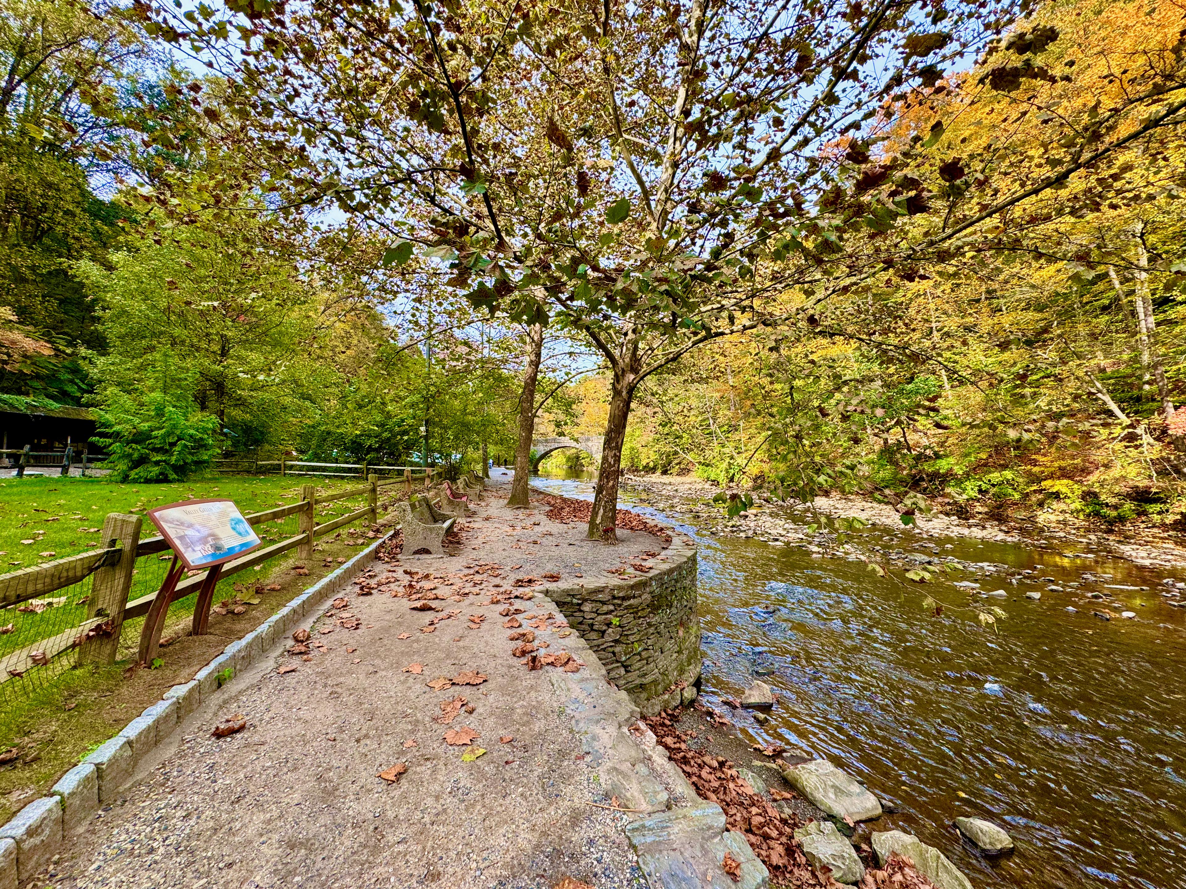
Stand on Forbidden Drive on an October morning, with the Wissahickon Creek sliding past on your left and the gorge rising on both sides, and the city disappears. There is no traffic noise, no skyline, no sidewalk — just water over rock, hemlock and oak closing overhead, and a wide gravel road running on through the trees. It is hard to believe, standing there, that you are still inside Philadelphia, twenty minutes from City Hall. That disbelief is the whole point of Wissahickon Valley Park.
The park protects 2,042 acres of woodland surrounding the Wissahickon Creek, running from the Montgomery County border in the northwest down to the creek's confluence with the Schuylkill River — a seven-mile corridor of gorge, meadow, and forest in the city's northwest corner. (Many local sources round the figure to "1,800 acres" or "about 2,000 acres"; the city's own watershed plan gives 2,042.) It is the second-largest park in Philadelphia, after Fairmount Park proper, and 1,250 acres of the valley were designated a National Natural Landmark in 1964. About 50 miles of trails thread through it, and more than a million people visit every year.
One thing to get straight before anything else: Wissahickon Valley Park is part of the Fairmount Park system, but it is not the same subject as Fairmount Park. Fairmount Park is the great designed landscape along the Schuylkill — the lawns, mansions, and museums of East and West Fairmount. The Wissahickon is something else entirely: a wild, wooded valley carved by a creek, with its own character, its own trails, and its own history. The two are administered together today under Philadelphia Parks & Recreation, and the valley was considered part of Fairmount Park from 1867 until the park commission merged with the Department of Recreation in 2010. But to walk the Wissahickon is to be in a different park — a gorge, not a garden.
The creek and the gorge
Everything in the park follows the Wissahickon Creek. The creek rises in Montgomery County, runs roughly north to south through the gorge, and empties into the Schuylkill River near Manayunk. Its name is generally translated from the Lenape as "catfish creek" — some sources give "stream of yellowish color" — and either translation tells you how long people have been paying attention to this water. The Lenape knew the creek long before Europeans arrived; the valley's first European settlers were drawn by the same thing that drew everyone after them, the creek's power and its beauty.
For several miles the creek winds through a steep, wooded gorge, cutting down through the rock of the Piedmont. The gorge is the park's defining feature and the reason it was protected at all: a dramatic, forested ravine that feels remote even as the neighborhoods of Chestnut Hill, Mount Airy, Roxborough, and Manayunk press in on its edges. In autumn the slopes turn gold and red; in winter the creek runs black between snow-dusted rocks; in spring the valley floor floods with wildflowers. The gorge has drawn artists for two centuries — Thomas Moran and other Hudson River School painters worked here, and Edgar Allan Poe wandered these paths while writing his essay "Morning on the Wissahiccon." The writers John Greenleaf Whittier, George Lippard, and William Cobbett all wrote about the valley, and the painters James Peale, William Trost Richards, and Currier and Ives all pictured it.
The creek is not scenery alone. It is a working waterway that still protects the drinking water of about a third of Philadelphians — the reason the city bought the valley in the first place, as the history below explains. And it is a living stream: herons stalk its shallows, wood ducks gather near the Valley Green Inn, and the pools and riffles hold fish through the year. Devil's Pool, where Cresheim Creek meets the Wissahickon, is one of the valley's best-known swimming holes in local lore — a deep, clear basin under the trees that has drawn swimmers for generations. (Check current conditions with Friends of the Wissahickon before visiting; the park's trails and water levels change with the seasons, and the Friends' site carries the current guidance.)
Forbidden Drive: the park's main artery
If the creek is the park's spine, Forbidden Drive is its main artery — a wide, car-free gravel road that runs the length of the valley, roughly 5.4 miles from the upper end of the park down toward Ridge Avenue and the Schuylkill. It is the easiest way into the Wissahickon and the route nearly every first-time visitor should take: flat, broad, and shaded, open to walkers, runners, cyclists, and horseback riders, with the creek almost always in sight or in earshot.
The drive's name is a piece of Philadelphia history in itself. The road began as the Wissahickon Turnpike, a toll road along the creek, and in 1920 the Fairmount Park Commission proposed opening it to automobiles. The response was a protest that has become park legend: 1,000 people on horseback and some 12,000 spectators on foot turned out to oppose cars on the turnpike. The cars were kept out, and the road became Forbidden Drive — forbidden to automobiles, open to everyone else. The protest is still celebrated every year in the Wissahickon Day Parade. The Friends of the Wissahickon, the nonprofit that has stewarded the park since its founding in 1924, was formed in the same spirit: park users and neighbors organizing to defend the valley.
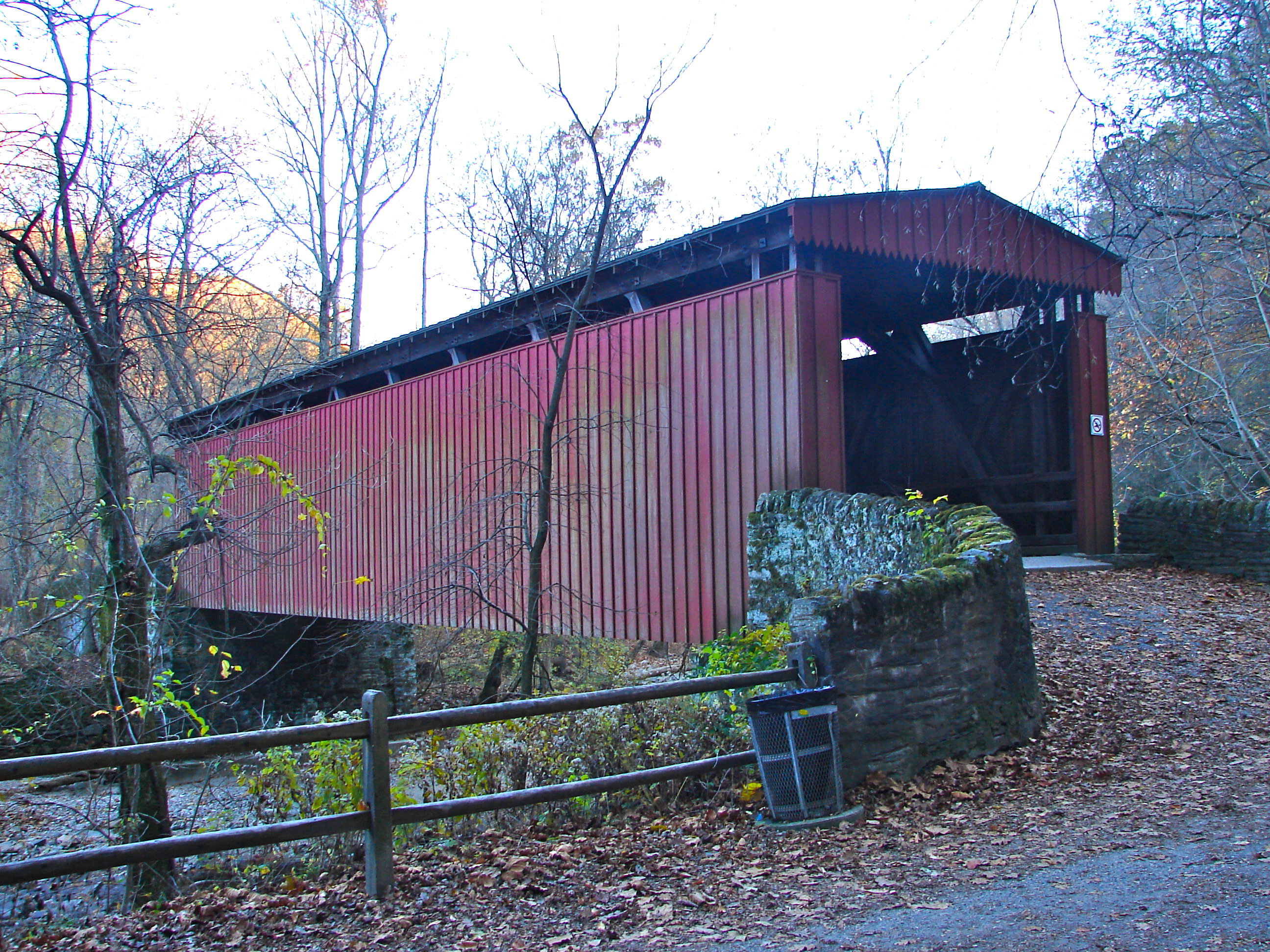
Walking Forbidden Drive today, the history is underfoot. The drive passes the remains of the valley's industrial past — old dams and mill races, stone abutments, the foundations of mills that once lined the creek — and the landmarks that survived it. From the drive you can reach the Thomas Mill Covered Bridge, Philadelphia's last remaining covered bridge and the only surviving covered bridge in a major American city, listed on the National Register of Historic Places since 1980. You can cross the Fingerspan Bridge, the sculptural steel footbridge artist Jody Pinto designed in 1987, which spans the gorge on the Orange Trail south of the Livezey Dam. You can look up at the Henry Avenue Bridge — formally the Wissahickon Memorial Bridge — the great stone arch that carries Henry Avenue high over the valley, and at the Walnut Lane Bridge and Kitchen's Lane Bridge, the stone spans that stitch the neighborhoods across the gorge. And at the drive's midpoint, you come to the Valley Green Inn.
Valley Green Inn: the heart of the gorge
If Forbidden Drive is the spine of the Wissahickon, the Valley Green Inn is its heart. The white-columned inn stands directly on Forbidden Drive at Valley Green Road, roughly at the center of the park, and it is the last surviving roadhouse of the seven that once lined the valley between 1840 and 1916. It was built in 1850 as a temperance hotel: Edward Rinker leased three acres from Thomas Livezey and built a small inn where travelers could rest, water their horses, and eat — no alcohol served. The Fairmount Park Commission acquired the land in the early 1870s, and the inn passed into the park's care. By 1899 it was in such poor condition that the park engineer recommended tearing it down; local citizens rallied, raised the money, and restored it, and in 1900 a group of prominent Philadelphia women took over its management. The Friends of the Wissahickon has been the inn's steward since 1937, renting it out as a restaurant. It did not serve alcohol until the 1980s, when it was finally granted a liquor license — more than 130 years after it opened as a temperance house.
The inn is still a working restaurant, and its porch overlooking the creek and the drive is one of the most pleasant places to sit in Philadelphia after a hike. It is also the park's most reliable landmark for a first visit: put "Valley Green Inn" into a map and it will anchor you at the middle of the gorge, with Forbidden Drive running in both directions and the trailheads fanning out from it. The inn's warming shed for horses has stood at this location since 1850, and the building itself is one of the most frequently painted and photographed sites in the valley — it appears in the park's earliest guidebooks and in paintings going back to the nineteenth century.
The other roadhouses are gone — the Indian Rock Hotel at Rex Avenue, the Wissahickon Hall, the rest — closed when the park banned alcohol within its boundaries and the park's borders expanded in 1916. Only Valley Green remains open for business, which is why it matters: it is the last physical trace of the valley's roadhouse era, the time when the gorge was a day's outing from the city and the inns along the turnpike were its rest stops.
Mills, mystics, and the water-supply story
The Wissahickon has been worked, worshipped, and fought over for more than three centuries, and the park's quiet trails hide more history than most Philadelphia neighborhoods can claim. In the late 1690s, the German mystic Johannes Kelpius and his followers settled briefly in a hollow along the gorge to meditate and await the millennium — the site is still known as Hermit's Cave, reachable from the Hermit Lane trailhead. A century later the valley became the city's first industrial corridor: grist mills and paper mills lined the creek from the late 1600s into the late 1800s, using the creek's fall to grind grain and make paper. RittenhouseTown, near the park's lower end, preserves the settlement where William Rittenhouse built a paper mill in 1690. The Livezey House — also known as Glen Fern — is a colonial-era mill house that still stands along the creek. The Hermitage Mansion, the Monastery House, Cedars House, and the Thomas Mansion are among the historic houses scattered through the valley, and the Philadelphia Canoe Club, founded in 1905, still occupies its clubhouse on the creek.
The mills were the reason the valley was saved. By the 1860s, Philadelphia's drinking water was under threat: the mills, tanneries, and settlements along the creek were polluting the water supply, and the city understood that the only way to protect it was to own the land. In 1868 the Fairmount Park Commission acquired the 1,800 acres of the Wissahickon Valley to preserve the purity of the city's water supply. The mills and taverns were demolished, the valley was closed to industry, and the gorge was left to return to forest. It was one of America's earliest large-scale conservation acts — a city buying a whole watershed to keep its water clean — and it is why the Wissahickon looks the way it does today: not a landscaped park, but a valley allowed to be wild. The land the commission bought still protects the drinking water of about a third of Philadelphians.
That conservation story is also why the valley feels different from the rest of Fairmount Park. The commission did not design the Wissahickon; it removed the things that were damaging it and let the forest come back. The stone bridges, the mill ruins, and the roadhouses are the remains of what was there before — and the gorge itself, designated a National Natural Landmark in 1964, is the reward.
The trail system: fifty miles above the creek
Forbidden Drive is the easy walk. The real hiking is on the color-coded trails that climb from the drive up into the wooded slopes on both sides of the gorge — about 50 miles of them in total, ranging from gentle riverside paths to steep, rocky climbs. The Orange Trail (about 5.7 miles) and the White Trail (about 4.7 miles) are the two great ridge trails, running the length of the park on opposite sides of the creek, high above Forbidden Drive, with the Fingerspan Bridge as the Orange Trail's signature crossing. The Yellow Trail (about 7.9 miles) winds through the upper valley, and the shorter Lavender Trail (about 1.3 miles) and the Andorra Meadow trails offer gentler loops. The trails are blazed in color and marked on the Friends of the Wissahickon's map — download the map or pick up a paper copy before you go, because cell service is spotty in the gorge and the side trails, unlike Forbidden Drive, are rugged, rooty, and easy to lose.
The trail system is also where the park's statues and oddities hide. The statue of Teedyuscung, the Lenape leader, by John Massey Rhind, stands in the woods above the creek, paired with a companion statue of Toleration. The statue of Henry H. Houston, the developer who built much of Chestnut Hill and the Wissahickon Inn, watches over the valley from its ridge. Mom Rinker's Rock — named for a woman who, legend says, hid American patriots and spied on the British during the Revolution — juts over the creek near the Valley Green Inn. These are not monuments on a mall; they are discoveries on a hike, which is exactly how the Wissahickon likes its history.
How to visit
The park is free and open dawn to dusk, seven days a week, under Philadelphia Parks & Recreation. There is no admission fee and no gate; you walk in from one of the trailheads. The most useful starting points are the Valley Green Road lots (the classic first visit, beside the Valley Green Inn), the Northwestern Avenue trailhead at 120 W. Northwestern Avenue in Chestnut Hill, Bells Mill Road, Rex Avenue, Hermit Lane, Kitchen's Lane (1000 Kitchens Lane), and the Ridge Avenue trailhead near the Wissahickon Transportation Center at 4900 Ridge Avenue in Manayunk. Parking in the designated lots is free, but the Valley Green Road lots fill early on weekend mornings in spring and fall — arrive before 9 a.m. or use one of the quieter trailheads.
By public transit, the Wissahickon Transportation Center at 4900 Ridge Avenue connects to the Ridge Avenue trailhead, and SEPTA bus routes 27, 97, 23, and 65 serve various entrances; Wissahickon Station on the Manayunk/Norristown Line and the Chestnut Hill West Line also put you within reach of the valley. The paved Wissahickon Trail (about 1.4 miles) links the Schuylkill River Trail to Forbidden Drive at the park's lower end.
Plan like a hiker, not like a tourist. Wear sturdy shoes if you leave Forbidden Drive — the side trails are steep and rocky. Carry water; there are restrooms at the Valley Green Inn, the Wissahickon Environmental Center, and the Kitchen's Lane lot, but not along the trails. Download the Friends of the Wissahickon map before you go, because cell service fails in the gorge. And check fow.org for current trail conditions before visiting: the Friends post closures, construction detours, and storm damage there, and conditions change — as of this writing, the upper Valley Green lot has seen closures for construction, and lower lots close on busy weekends. The park rewards the prepared and punishes the casual, which is part of its charm.
The best first visit is simple: park at Valley Green Road, walk Forbidden Drive south toward the Thomas Mill Covered Bridge or north toward Bells Mill Road, and come back past the inn for lunch on the porch. The best second visit is harder: take the Orange Trail up to the ridge, cross the Fingerspan Bridge, and come down the White Trail on the other side. The best third visit is the one you plan yourself, with the map, in a season you have not seen yet. The valley is different in every one of them.
Key Facts
- Wissahickon Valley Park is a 2,042-acre park in northwest Philadelphia, Pennsylvania, protecting the woodland around the Wissahickon Creek from the Montgomery County border to its confluence with the Schuylkill River. Coordinates (Wikipedia infobox, central park point): 40.05, -75.215. It is the second-largest park in Philadelphia after Fairmount Park, and is administered by Philadelphia Parks & Recreation as part of the Fairmount Park system — but it is a distinct park, a wooded gorge, not the same subject as Fairmount Park proper.
- The Wissahickon Creek runs roughly seven miles through the park in a steep, wooded gorge. The creek's name is generally translated from Lenape as "catfish creek." About 50 miles of trails run through the park, and it draws more than a million visitors a year.
- The Fairmount Park Commission acquired the valley in 1868 to preserve the purity of Philadelphia's drinking water; the mills and taverns were demolished and the gorge returned to forest. The valley was considered part of Fairmount Park from 1867 until the park commission merged with the Department of Recreation in 2010. A 1,250-acre area of the valley was designated a National Natural Landmark in 1964.
- Forbidden Drive, formerly the Wissahickon Turnpike, is a wide car-free gravel road about 5.4 miles long running the length of the valley, open to walkers, runners, cyclists, and horseback riders. In 1920, when the Park Commission proposed allowing cars on the turnpike, 1,000 protesters on horseback and 12,000 spectators on foot turned out against it; the road has been closed to automobiles ever since, and the protest is celebrated annually in the Wissahickon Day Parade.
- The Valley Green Inn, built in 1850 as a temperance hotel by Edward Rinker on land leased from Thomas Livezey, is the last surviving roadhouse of the seven that lined the valley between 1840 and 1916. The Fairmount Park Commission acquired the land in the early 1870s; the inn was nearly demolished in 1899, restored after a citizens' campaign, and managed from 1900 by a group of Philadelphia women. The Friends of the Wissahickon has been its steward since 1937. It did not serve alcohol until the 1980s.
- The valley's industrial history runs from the late 1600s to the late 1800s: grist mills and paper mills lined the creek, including the Rittenhouse paper mill settlement of 1690 (RittenhouseTown) and the Livezey House (Glen Fern), a colonial-era mill house. In the late 1690s the German mystic Johannes Kelpius and his followers settled at what is now Hermit's Cave.
- The gorge inspired writers Edgar Allan Poe, John Greenleaf Whittier, George Lippard, and William Cobbett, and artists Thomas Moran, James Peale, William Trost Richards, and Currier and Ives.
- The Friends of the Wissahickon (FOW), the nonprofit steward of the park, was founded in 1924 by park users and neighbors.
- Landmarks in the park include the Thomas Mill Covered Bridge (Philadelphia's last covered bridge and the only surviving covered bridge in a major American city; on the National Register of Historic Places since December 1, 1980), the Fingerspan Bridge by artist Jody Pinto (commissioned 1987, on the Orange Trail), the Henry Avenue Bridge (Wissahickon Memorial Bridge), the Walnut Lane Bridge, the Kitchen's Lane Bridge, Devil's Pool at the confluence of Cresheim Creek and the Wissahickon, the statues of Teedyuscung (by John Massey Rhind) and Henry H. Houston, and Mom Rinker's Rock.
- The color-coded trail system includes the Orange Trail (about 5.7 miles), White Trail (about 4.7 miles), Yellow Trail (about 7.9 miles), and Lavender Trail (about 1.3 miles), plus the Andorra Meadow trails. Forbidden Drive is about 5.4 miles; the paved Wissahickon Trail (about 1.4 miles) links the Schuylkill River Trail to Forbidden Drive.
Location Photography