
Boston's riverfront backyard
The Charles River Esplanade is a three-mile, roughly 65-acre ribbon of parkland along the south bank of the Charles River Basin in Boston, running from the Museum of Science at the Craigie Drawbridge west to the Boston University Bridge. On its north side is the river — wide, still, and full of sailboats. On its south side is Storrow Drive, a highway that hums behind a line of trees. Between the two is the park: a paved promenade where runners, cyclists, and strollers pass each other all day; the Hatch Memorial Shell, a granite bandshell where the Boston Pops play every Fourth of July; the Storrow Lagoon, where the Back Bay skyline reflects in still water; and Community Boating, the country's first public sailing program, where children learn to sail in the shadow of the Longfellow Bridge.
It is the most used park in Boston that is not the Common or the Public Garden, and it is the most artificial. Almost nothing about it is natural. The river basin is a dammed lake. The land under the lawns is fill pumped from the riverbed. The lagoon is a landscape architect's invention, and the islands in it were built to replace parkland a highway took away. The Esplanade is a park that Boston made for itself, out of a tidal estuary that smelled so bad at low tide that people considered it a liability — and then, over a century, rebuilt it three times, each time bigger and better.
It is also a park that belongs to everyone in a way few Boston places do. There is no gate and no admission charge. The concerts at the Hatch Shell are free. The sailing program was founded on the idea that anyone, not just members of a yacht club, should be able to get on the water. On a summer evening the Oval lawn in front of the Hatch Shell fills with picnics; on a winter morning the promenade belongs to runners and the ducks. The Esplanade is where Boston goes when it wants to be outside, together, with the river in front of it and the city behind it.
Before the park: mud flats and the Quinobequin
For millennia before there was a Boston, the river now called the Charles was the Quinobequin, and the Massachusett people fished its tides with weirs, traveled and traded along its waters, and farmed and hunted on its banks, with Nipmuc neighbors to the west and Wampanoag neighbors to the south. The arrival of European colonists led to the violent displacement of the Massachusett people from what is now Boston — the Neponset band, for example, saw its territory diminished and was forced over the Blue Hills to a smaller territory at Ponkapoag. The Commonwealth took the people's name for itself, and today the Massachusetts Department of Conservation and Recreation oversees the Esplanade among many public state parks. The Esplanade Association, the park's nonprofit friends group, works in partnership with the DCR and strives to honor the connection between the site and the region's Indigenous peoples' ongoing stewardship of the land and water.
The Boston that grew up along the river in the 19th century did not love it. The Back Bay, the neighborhood the Esplanade now borders, was itself a tidal flat, filled in over decades in the second half of the 19th century; Back Street and its seawall formed most of the river's northern edge by the 1870s. At low tide the Charles was a foul-smelling expanse of mud flats, fouled by the sewage of the new Back Bay houses. The river was a liability, and the question of what to do with it was one of the great civic arguments of the 1870s and 1880s.
The answer came from the man who had already given Boston its park system. In 1876, the Boston Park Commission, advised by Frederick Law Olmsted, proposed a connected system of parks along the Charles River — part of the vision that would become the Emerald Necklace, the chain of parks linked by parkways and waterways running through Boston and Brookline. The riverfront park was the missing piece: a place where the city met the water.
Olmsted's Charlesbank: the first public gymnasium
The first piece of the Esplanade to become parkland was its easternmost section, Charlesbank, built in the 1880s and 1890s on filled land north of Charles Street, between what is now the Museum of Science and the Longfellow Bridge. A seawall was built in the 1880s, and Frederick Law Olmsted Sr. designed a pioneering park here — a riverside promenade, landscaped grounds for active and passive recreation, and, most remarkably, the first free public outdoor gymnasium in the United States.
That detail matters, because it tells you what the park was for. Charlesbank was not built as a scenic overlook for the wealthy of Beacon Hill. It was built for the largely immigrant population of the West End, living in disease-ridden tenements a few blocks away, and its purpose was public health: free open-air athletic facilities, a promenade, and green space for people who had none. Olmsted's plan, drawn in 1892, gave the poorest neighborhood in the city a riverfront. It was a radical idea — that a park could be a piece of public-health infrastructure — and it was the beginning of the Esplanade.
Charlesbank was expanded and modified in 1908 by the landscape architect Guy Lowell, but it remained a narrow, linear park along a tidal river. The river itself was the problem. Until the Charles was tamed, no park along it could be more than a walkway above the mud.
The dam that made the basin
The taming came from a Boston Brahmin named James Jackson Storrow, who was most responsible for the building of the dam that made the modern Esplanade possible. Storrow had been instrumental in the campaign for the Charles River Dam, and the dam's construction in 1908–1910 transformed the tidal estuary into a broad, fresh-water basin with a constant water level. The mud flats disappeared. In their place was a wide river, held steady, with banks that could be planted and walked on.
The Esplanade was born in 1910, dedicated as the Boston Embankment. But the first version was a disappointment: a narrow, roughly 100-foot-wide walkway along the water's edge, a formal edge between the river and the city with too few shade trees, no refreshment stands, no recreation facilities, and little to draw visitors. It connected with Olmsted's Emerald Necklace at Charlesgate, upstream of the Harvard Bridge, but it was a promenade, not a park. The city had built the water; it had not yet built the park to go with it.
The missing piece arrived after James Storrow's death. His widow, Helen Osborne Storrow, gave $1 million — an enormous sum in the 1920s — to carry out a comprehensive plan for the beautification and improvement of the Charles River Basin, in memory of her husband. A Special Commission on the Charles River Basin recommended expanding the recreational opportunities along the river by removing the embankment walls and widening the park with fill pumped from the riverbed. Augmented by $2.3 million in public funding, the project transformed the Esplanade.
Shurcliff's Esplanade: the Storrow gift and the 1930s transformation
The man who designed the transformation was Arthur A. Shurcliff (1870–1957), a Boston landscape architect and a protégé of Charles Eliot, the visionary who had founded the Metropolitan Park Commission in 1893 with Sylvester Baxter to acquire and protect the region's finest natural resources. Shurcliff worked on the Esplanade for more than twenty-five years, and the park he built is the park you walk through today.
Between 1928 and 1936, Shurcliff's plan nearly doubled the parkland, adding more than 40 acres. He planted trees, redesigned the water's edge, added canoe ways, docks, pathways, and monuments, and built the park's defining features: the first lagoon — the Storrow Lagoon, a formal body of water between Exeter and Fairfield Streets — with boat landings, plazas, and playgrounds; three granite overlooks; a boat haven with breakwaters; and an enlarged Music Oval, the site of the Hatch Shell. The expanded park was dedicated as the Storrow Memorial Embankment, a name that never took hold — everyone kept calling it the Esplanade.
Shurcliff's design was formal and generous at once: long allées of trees, a wide promenade along the water, and the lagoon as a quiet counterpoint to the river — a place for still water and reflections, where the Back Bay's brick and glass towers mirror themselves. The Charles Eliot Monument, designed by Shurcliff, became a focal point of the park, and it was restored in recent years by the Esplanade Association. The park that emerged in the 1930s was, in the words of the Boston Landmarks Commission, which designated the Esplanade a Boston Landmark in 2009, a landscape of national significance — a fully man-made park conceived as the central court of honor of a metropolitan park system.
The Hatch Shell and the Pops
The centerpiece of Shurcliff's park, and the reason most Americans have heard of the Esplanade, is the Hatch Memorial Shell. Its story begins in 1928, when a young violinist in the Boston Symphony Orchestra named Arthur Fiedler — who liked to walk along the Esplanade and dreamed of bringing music to the general public outside the confines of Symphony Hall — persuaded the city to build a temporary wooden shell for the Boston Pops. The first concert was on July 4, 1929, with Fiedler conducting the Boston Pops in the temporary shell and the new Music Oval.
The wooden shell was dismantled and reassembled every year from 1929 to 1934. Then a temporary steel structure was built — but it proved too hot for the performers, and in 1938 a devastating hurricane blew out its back. The Pops had a stage but no money for a permanent one, and the Depression had emptied the city's coffers. The money came from an unexpected place: in 1936, the Massachusetts Attorney General, Paul A. Dever, discovered the will of Maria Hatch, who had left funds for a public memorial in memory of her brother, Edward Hatch, a descendant of a colonial Massachusetts family whose fortune had been made in foreign trade. The trustees agreed that a permanent concert shell on the Esplanade was the most suitable use of the bequest.
The permanent shell, designed by the Boston architect Richard J. Shaw — best known for his churches — was dedicated on July 2, 1940, and constructed the following year. It is one of Boston's prominent examples of Art Deco architecture: a granite structure 40 feet high and 110 feet wide, with a terrazzo-tiled roof and an interior of warm wood, its exterior lined with the names of the composers whose music Fiedler conducted here over the decades. The original wooden shell had been built in 1928 as a temporary venue; the permanent one, dedicated in 1940 and built in 1941, is the third shell on the site.
The Hatch Shell is best known for the Boston Pops' annual Fourth of July celebration, but for most of its history it was a working summer stage, hosting free concerts most weekends and many weeknights. The Fourth of July concert itself got a new lease on life in 1974, when Fiedler and the Boston businessman David Mugar reinvented it as a spectacular event. On July 4, 1976, for the Bicentennial, Fiedler conducted Tchaikovsky's 1812 Overture with cannons, church bells, and fireworks over the river — an estimated 400,000 people attended — and the 1812 has closed the program every year since. Mugar financed the performance for the next 25 years. The concert and fireworks are now the most widely known image of the Esplanade, and the biggest free event in Boston every year.
The shell has been a stage for far more than the Pops. The Boston Landmarks Orchestra, founded in 2001, made the Hatch Shell its principal home, returning the tradition of free summer concerts to the park. Jazz ensembles from local high schools, rock bands, folk singers, and movie nights have all played the Oval. Performers over the decades have ranged from Aerosmith and James Taylor to Green Day and the Stylistics. In 2018 the shell underwent a $2.4 million renovation, its first since 1989. A memorial nearby honors Arthur Fiedler — a statue and a footbridge bear his name — and the Arthur Fiedler Footbridge, completed in 1953, is one of the main ways to reach the park from Beacon Hill.
Storrow Drive cuts the park in two — and the park fights back
The next great change to the Esplanade began in 1949, with the construction of Storrow Drive. The highway had been part of the original 1930s plan — a proposed road from the Longfellow Bridge to the Cottage Farm (Boston University) Bridge — but it had been omitted from the 1930s improvements after tremendous public protest. After the war, it came back. Construction took place in 1950–1951, and Storrow Drive — officially the James Jackson Storrow Memorial Drive — was opened in a ribbon-cutting ceremony by Governor Paul A. Dever on June 15, 1951.
The road cut the Esplanade off from the neighborhoods behind it and took a strip of parkland with it. Shurcliff, retained to assist with the road's layout and the replacement of the lost parkland, worked with his son Sydney on what the landscape historian Linda M. Cox called a brilliant and simple solution: they lengthened the outer barrier of the existing lagoon, creating a new, undulating island connected to the original shoreline by footbridges, and added a series of lagoons and an undulating shoreline between the Harvard and BU Bridges. Land taken by the highway had to be replaced by reclaiming new land along the shoreline, and the islands and lagoons you walk through today west of the Hatch Shell are the result — parkland invented to make up for parkland lost.
The highway also severed the Esplanade's connection to the Emerald Necklace at Charlesgate, where the Muddy River meets the Charles — a break that lasted more than seventy years. The Bowker Overpass rehabilitation project, now moving forward with MassDOT, is designed to reestablish that connection, replacing the structurally deficient overpass and restoring usable open space along the river, reconnecting the banks of the Muddy River to the Esplanade.
Because Storrow Drive is a high-speed, limited-access parkway — restricted to cars, with unusually low clearances that exclude trucks and buses — pedestrian access to the Esplanade is only by overpass. The footbridges are part of the park's experience: the Blossom Street bridge near Massachusetts General Hospital, the Frances Appleton Bridge at Cambridge Street next to the Longfellow Bridge, the Arthur Fiedler Bridge at Arlington Street by the Hatch Shell, and the pedestrian overpass near the Longfellow Bridge, built in 1962. Each one is a small threshold — you climb up over the traffic, and on the other side is the river.
The Lagoon, Community Boating, and the river life
If the Hatch Shell is the Esplanade's stage, the Lagoon and the boathouse are its daily life. Sailing on the Charles began in the 1930s, and the country's first community boating program was begun on the Esplanade in the mid-1930s. Community Boating was formally organized in 1946 as the nation's first public boating program: for a modest fee, thousands of people — children especially — have learned to sail on the Charles River, no yacht-club membership required. The boathouse, designed by Kilham, Hopkins and Greeley, was built in 1941 and still anchors the middle of the park, its docks crowded with small sailboats on summer afternoons. The Union Boat Club, one of the country's oldest rowing clubs, keeps its boathouse along the same stretch of river.
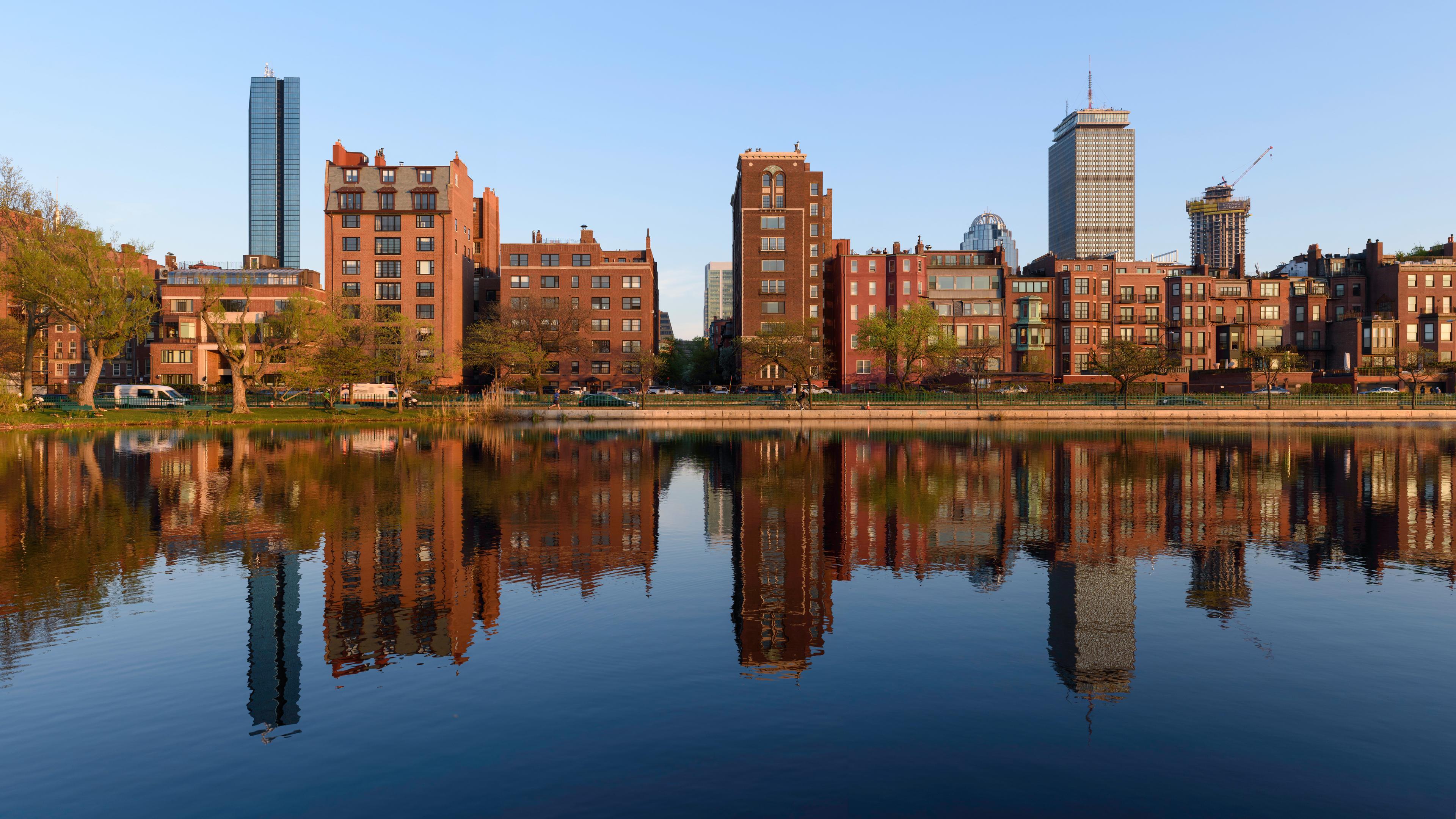
The Storrow Lagoon, Shurcliff's invention, is the park's quietest place. It is a long, still body of water separated from the river by a strip of parkland, crossed by small footbridges, its banks planted with willows and maples. On a calm morning the Back Bay skyline — the Prudential Tower, the Hancock Tower, the brownstones of Beacon Street — reflects in it so clearly that the photograph looks upside down. The lagoon's islands, built after Storrow Drive, are linked by footbridges and make a small archipelago of lawns and paths, a place for picnics and for watching the swans.
The river itself is the park's other half. The basin is wide and calm, and on a summer day it is full of sailboats from Community Boating, kayakers, crew shells, and the occasional duck boat. The promenade along the water is the park's main street: runners at dawn, commuters on bicycles, families with strollers, and, in the evening, people just walking to look at the skyline. The park's three segments each have their own character — Charlesbank at the eastern end, quiet and green below Beacon Hill; the Back Bay section between the Longfellow and Harvard Bridges, where the Hatch Shell, the Lagoon, and Community Boating all sit; and the western stretch toward the BU Bridge, wilder and more open, where the river bends and the city thins out.
The Esplanade today: restoration and the Association
By the end of the 20th century, the Esplanade needed help. Decades of use, and of deferred maintenance by the state, had worn the park down. In 2001, the Esplanade Association was formed as a nonprofit friends group to restore and enhance the park in partnership with the Massachusetts Department of Conservation and Recreation, which owns and manages it as part of the Charles River Reservation, a linear park system stretching 17 miles along the river.
Since then, the Association has been the catalyst for millions of dollars in park improvements: rebuilding docks, building new playgrounds, revitalizing the Eliot Memorial, restoring the Lotta Fountain and the Hatch Shell Oval lawn, and adding park programs and amenities. In 2010, for the Esplanade's centennial, the Association launched Esplanade 2020, a once-in-a-generation plan for the park's future — and it is now at work on Charlesbank Landing, a major new project at the park's eastern end. The park continues to evolve: the Esplanade Association's work, and the Bowker Overpass project at Charlesgate, are the latest chapters in a century of rebuilding.
What has not changed is the park's purpose. The Esplanade is still what Olmsted intended Charlesbank to be: a public place, free, on the water, for everyone. It is where Boston goes to run, to sail, to listen to music, to watch fireworks, and to sit on a bench and look at the river. It is a park that was made from mud flats by a dam, doubled by a widow's gift, cut by a highway, and rebuilt by its neighbors — and it is, three miles long, the city's backyard.
Walking the Esplanade
Start at the eastern end, at Charlesbank, below Beacon Hill, where Olmsted's first park still runs along the river beneath the Longfellow Bridge. Walk west along the promenade and the park opens up: the tree-lined path, the river on your left, the city on your right. At the Frances Appleton Bridge you cross into the Back Bay section, and the Lagoon appears on your right, its footbridges and islands, the Back Bay skyline reflected in still water.
Keep walking and you reach the Hatch Memorial Shell and the Oval lawn, the park's great open room. Stand on the Oval and look at the shell — the granite, the Art Deco curve, the composers' names — and imagine it full on the Fourth of July, with the Pops on stage and the fireworks over the river. Just beyond is Community Boating, its docks and sailboats, and the Union Boat Club. The Arthur Fiedler Footbridge crosses Storrow Drive here, back toward Beacon Hill and Arlington Street.
West of the Harvard Bridge, the park changes again: the lagoons multiply, the shoreline undulates, the islands Shurcliff and his son built to replace what the highway took. The path runs on to the BU Bridge, where the Esplanade ends and the river continues upstream. Three miles, and you have walked through a century of Boston's history — from a tidal flat to a dammed basin, from a widow's million to a highway, from a wooden bandshell to a stage the whole country watches every July.
How to visit
The Charles River Esplanade runs along the south bank of the Charles River in Boston's Back Bay, from the Museum of Science (Craigie Drawbridge) east to the Boston University Bridge west — about three miles end to end. The Hatch Memorial Shell, the park's centerpiece, sits near Arlington Street, at approximately 42.3547, -71.0726. Reach the park on foot from Beacon Hill or Back Bay over the pedestrian bridges — the Arthur Fiedler Footbridge at Arlington Street by the Hatch Shell, the Frances Appleton Bridge at Cambridge Street by the Longfellow Bridge, or the Blossom Street bridge near Massachusetts General Hospital. The nearest MBTA stations are Charles/MGH (Red Line) at the eastern end and Arlington (Green Line) near the Hatch Shell. Entry to the park is free and it is open year-round. Allow at least an hour for a walk between two bridges, and a half day if you want to walk the full three miles, linger at the Lagoon, and watch the sailboats. The Hatch Shell's free summer concerts run on weekends and many weeknights; the Boston Pops Fourth of July concert and fireworks are the park's biggest night of the year — arrive early and expect crowds. No fixed prices for Community Boating memberships or any other fees are stated in this article, since none was verified against an official source in this run: check community-boating.org and esplanade.org before visiting for current details.
Charles River Esplanade in photographs