
The wild end of Key Biscayne
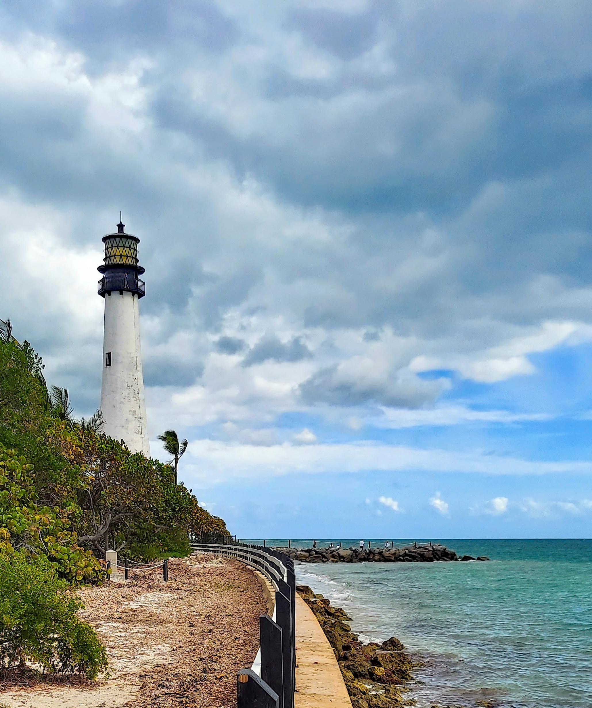
Drive south down Crandon Boulevard, past the village of Key Biscayne, and the island narrows and greens until the road ends at Bill Baggs Cape Florida State Park: about 400 acres covering the southern third of Key Biscayne, a barrier island joined to the mainland by the Rickenbacker Causeway. On the park's eastern side, more than a mile of natural Atlantic beach runs north from the lighthouse, dunes covered in sea oats and sea grape, the water clear and gentle behind a reef six miles offshore. On the western side, Biscayne Bay laps a long seawall, and in the park's northwest corner sits No Name Harbor, a sheltered natural anchorage where sailboats swing at anchor and the Boater's Grill serves lunch on the water. Between the two shores are picnic areas, a 1.5-mile paved bike path, nature trails through mangrove wetlands and coastal hammock, and the densest birdlife in Miami-Dade County.
It is, by most measures, the best beach park in Miami — the beach has been ranked among the top ten in America repeatedly by Dr. Stephen Leatherman, known as Dr. Beach — and it is also the most historically loaded ground in the county. The Cape Florida Lighthouse at its tip is the oldest standing structure in Miami-Dade County. Before the lighthouse, this shore was a gateway to freedom. After it, the light became a symbol of the city that grew up around it. The park is named for a newspaper editor who saved it from development in the 1960s, and it still feels like a rescue: a stretch of old Florida, ten miles from downtown Miami, that the city never managed to pave over.
Before the lighthouse: a shore of escape
Long before there was a lighthouse, or a park, or a Miami, this coast belonged to the Tequesta, the Indigenous people of the Biscayne Bay shore, who fished these waters and camped on these keys for centuries. The Spanish knew the cape too: Ponce de León named it the "Cape of Florida" when he led the first Spanish expedition to Florida in 1513, and the name stuck.
The chapter of this shore's history that matters most began when Spain handed Florida to the United States. Under Spanish rule, many Black people in Florida were free, and they feared — correctly — that American rule would end that freedom. In the early 1820s, enslaved Africans, runaways, and Black Seminoles — people of African descent who had found refuge among the Seminole — made their way secretly down to Cape Florida. There they met Bahamian sloops whose captains offered passage across the Gulf Stream to the British Bahamas, where slavery had been abolished. Eyewitnesses in 1821 reported some 300 freedom seekers bartering for passage aboard 27 sloops, while others set out in dugout canoes on the 107-nautical-mile crossing to Andros Island. Their descendants still live in the Red Bays settlement on Andros, and some still call themselves Black Seminoles.
This was the Saltwater Railroad, the seagoing cousin of the Underground Railroad, and Cape Florida was one of its main departure points. The park remembers it plainly: in September 2004, Cape Florida was designated a National Underground Railroad Network to Freedom Site — one of only two parks in Florida to hold that distinction — and a historical marker near the lighthouse tells the story. The cruel irony of the place is part of the story too. The lighthouse built in 1825 to save sailors' lives also cast a light across the very beach the freedom seekers used, and its construction effectively closed the escape route. The beacon that guided ships home ended the journeys of people trying to reach one.
The lighthouse rises — and burns
The Florida Reef, a long coral barrier running parallel to the coast just offshore, wrecked ship after ship on the approach to Biscayne Bay. In 1825 the federal government built the Cape Florida Lighthouse to guide mariners off the reef: a 65-foot brick tower on the southern tip of Key Biscayne, one of the first permanent structures in what would become Miami-Dade County. A London-born American woman, Mary Ann Davis, sold three acres of her property to the government for the lighthouse, and she and her husband later laid out the first town of Key Biscayne around the lighthouse compound in 1839, offering 264 lots for sale. The first keeper was Captain John Dubose, who served for more than ten years.
The lighthouse's first decade was a battering. A major hurricane in 1835 damaged the tower and the keeper's house and flooded the island under three feet of water. Then came the Second Seminole War, which began in 1835 as the United States pressed to remove the Seminole from Florida. On July 18, 1836, Captain Dubose left to visit his family in Key West, leaving the assistant keeper, John W. B. Thompson, in charge, aided by Aaron Carter, an African American assistant. Five days later, on July 23, 1836, a band of Seminole warriors attacked the lighthouse station.
Thompson and Carter retreated up the tower as the attackers set fire to the wooden door and the stairs below. Rifle balls pierced the tanks at the base of the tower that held 225 gallons of lamp oil, and the oil caught fire. The two men were driven out onto the two-foot-wide platform that ran around the outside of the lantern, trapped above the flames. Carter was killed in the attack. Thompson, badly wounded, threw a keg of gunpowder down the shaft in a desperate attempt to make an explosion that would attract a Navy vessel offshore — and it worked. The schooner USS Motto rescued him. The lighthouse itself was gutted and dark for a decade.
Rebuilt, raised, and relit
The tower was rebuilt in brick in 1846 — fireproof this time — and it remains the oldest standing structure in Miami-Dade County. In 1855 it was raised to its present 95 feet and fitted with a powerful second-order Fresnel lens. The U.S. military built Fort Dallas beside the ruined lighthouse in 1838, during the war, and Confederate sympathizers vandalized the light during the Civil War. It kept working until 1878, when a new lighthouse on the offshore reef at Fowey Rocks replaced it, and the Cape Florida light went dark.
The land around it changed hands for the next century — the Davis family, then James Deering, then Waters Davis, who bought the lighthouse and its grounds back from the federal government in 1903 for $400 — while the tower stood empty and the beach eroded so badly in the early twentieth century that the lighthouse nearly fell into the sea. In 1966, the State of Florida bought the southern third of Key Biscayne, including the lighthouse, and established Bill Baggs Cape Florida State Park. The deal was arranged by Bill Baggs, editor of The Miami News from 1957 to 1969, who brought the landowner, Elena Santeiro Garcia, together with the state; the park was named for him, and it opened on January 1, 1967. Baggs was a civil-rights-minded journalist who had argued for years that this shore should belong to the public, and the park is his monument as surely as the lighthouse is the county's.
The lighthouse itself came back to life in the 1990s. A full restoration returned the tower and the keeper's cottage to their nineteenth-century appearance — the cottage rebuilt and furnished to show how keepers and their families lived on what was, for most of the century, one of the remotest posts on the American coast — and the light was relit in 1996. The Coast Guard had briefly put the tower back into service in 1978 to mark the Florida Channel, the deepest natural channel into Biscayne Bay, and decommissioned it again in 1990; today it is owned and operated by the Florida Department of Environmental Protection as the centerpiece of the park.
Climbing the tower
The climb is the park's signature experience, and it is worth planning a visit around — with one important warning, noted below. Guided tours of the 95-foot lighthouse and the keeper's cottage are normally offered Thursday through Monday at 10:00 a.m. and 1:00 p.m., weather permitting, free with park entry and with no reservation needed; children must be at least 42 inches tall to climb. The ascent is 109 iron spiral steps to the lantern room, and the reward is a 360-degree view: the Atlantic to the east, Biscayne Bay and the Miami skyline to the north and west, the reef line offshore, and Stiltsville's stilt houses in the distance. The guides tell the 1836 attack story well, and the keeper's cottage — a reconstruction furnished as a nineteenth-century keeper's home — gives the human scale of a posting that was, for decades, reachable only by boat.
Check before you go: as of late October 2026, the lighthouse grounds were closed and tours canceled because of king-tide flooding — water rose above the seawall at No Name Harbor and around the lighthouse grounds on October 25–28, 2026, in what the park's friends group called an extraordinary flood, the first outside hurricane conditions to overtop the seawall there. The closure was in effect until further notice at the time of writing, and the fishing piers and beach access 3 were also closed for repairs. The park itself, the beach, and the trails remained open. Confirm the lighthouse has reopened on the official park page or by phone before planning a visit around the climb.
The beach
The Atlantic beach is the reason most Miamians come, and it is the quietest good beach in the city. It runs about a mile and a quarter north from the lighthouse, a natural shoreline of pale sand and dunes, deliberately kept ungroomed: sea oats and sea grape hold the dunes, boardwalks and sandy paths cross them to the water, and the beach is a nesting ground for loggerhead sea turtles in the summer months (nesting season runs roughly May to October; marked nests must be left alone). The water is gentle — the reef six miles out takes the surf — and clear enough for snorkeling along the shore. There are no lifeguards, so swim with care and watch the ranger-station warnings, particularly for Portuguese man-of-war in winter.
The beach is long enough that it never feels crowded the way South Beach does, even on weekends — though the park does fill up on weekends and holidays, and when it reaches capacity it closes to everyone, including people arriving on foot or by bicycle, for at least two hours. Beach wheelchairs and a swimming wheelchair are available free of charge; ask at the entrance station. Come early, bring shade, and walk the full length: the southern end, by the lighthouse, is the most scenic, and the northern end, near the entrance, has the most parking.
No Name Harbor and the bay side
The park's other shore is its secret. No Name Harbor, a natural harbor in the park's northwest corner on the Biscayne Bay side, is a sheltered anchorage where sailboats and powerboats tie up — Bimini is 48 miles east, and plenty of boats stage here before crossing to the Bahamas. There is a seawall for fishing, a picnic area, and the Boater's Grill, a waterfront restaurant on the harbor's edge, with a second concession and café near the middle of the beach. The long seawall along the bay is one of the best free fishing spots in Miami, though the fishing piers themselves were closed for repairs at the time of writing. Kayaks and canoes can be launched from the seawall at No Name Harbor, and bike and kayak rentals are available in the park.
The bay side is also where the sunsets happen. Florida State Parks advises visitors to stay for them, and the advice is sound: the sun drops over Biscayne Bay and the Miami skyline, the water turns gold, and the lighthouse stands black against it. It is the view that makes the park feel like the edge of something — which is exactly what it is.
Trails, mangroves, and birds
Between the two shores, the park protects coastal strand, mangrove wetlands, seagrass flats, and a tropical hardwood hammock that grew back after Hurricane Andrew devastated it in 1992. A multiyear effort has planted some 300,000 mangroves in the park, restoring acres of mangrove forest whose tangled roots serve as nurseries for juvenile fish, crabs, and shrimp. Manatees forage offshore in the seagrass meadows, green and leatherback sea turtles swim past, and American crocodiles are known to find refuge in the park's remoter corners.
The trails are flat, easy, and short — this is a park for wandering, not hiking. A 1.5-mile paved bike and walking path runs the length of the park from the entrance to the lighthouse, and unpaved service roads make a loop of a few miles. Two nature trails start near the Boater's Grill parking area on the west side: a mangrove wetlands trail (about 1.5 miles, on boardwalk through red mangrove habitat) and a coastal strand trail through sea grape and coastal vegetation toward the beach. A shorter birding trail, Robin's Birding Trail, runs about half a mile through prime migratory habitat.
Birding is the park's quiet superpower. Key Biscayne is a stopover for migrating songbirds crossing open water, and the park is part of the Great Florida Birding Trail. The Cape Florida Banding Station, established in 2002 and the only long-term bird-banding station in South Florida, operates 22 mist nets over 10 acres from mid-August through the first week of November, studying the migration. Ospreys and pelicans are everyday sights; peregrine falcons pass through in season; and the restored native plantings along the trails provide insects, fruit, and shelter that keep the birds coming. Bring binoculars in fall, when the banding station is running and the migrants are thickest.
How to visit
Bill Baggs Cape Florida State Park sits at the southern tip of Key Biscayne, at 1200 South Crandon Boulevard, Key Biscayne, FL 33149 — about ten to twelve miles from downtown Miami, reached by the Rickenbacker Causeway (which carries a toll). The park is open 8 a.m. to sunset, 365 days a year, according to Florida State Parks. An entrance fee is required; no fee amount is stated as fact in this article, since none was verified against the official source in this run — check floridastateparks.org before visiting for current fees, and call (305) 361-5811 with questions. Allow half a day: a morning for the lighthouse tour and the beach, longer if you want the trails, the harbor, and the sunset. Come early on weekends — the park closes at capacity — and come in fall for the bird migration, or in summer for the warmest water and the sea turtle nesting season. And before any visit that depends on the lighthouse, check that the grounds have reopened after the October 2026 king-tide flooding closure.
Location Photography


Key Facts
- Bill Baggs Cape Florida State Park covers about 400 acres (409 acres in the state park system's listing) at the southern tip of Key Biscayne, the southern third of the island, a barrier island connected to Miami by the Rickenbacker Causeway. It protects coastal strand, mangrove wetlands, seagrass flats, and more than a mile of Atlantic beachfront. Coordinates: 25.6678, -80.1565.
- Ponce de León named the cape the "Cape of Florida" during the first Spanish expedition to Florida in 1513. The shore was part of the world of the Tequesta, the Indigenous people of the Biscayne Bay coast.
- In the early 1820s, Cape Florida was a departure point of the Saltwater Railroad: enslaved Africans, runaways, and Black Seminoles secretly gathered here and sailed for the British Bahamas — eyewitnesses in 1821 reported some 300 freedom seekers aboard 27 sloops, with others crossing 107 nautical miles by dugout canoe to Andros Island. In September 2004, Cape Florida was designated a National Underground Railroad Network to Freedom Site, one of only two parks in Florida with that distinction. The lighthouse built in 1825 effectively ended the escape route, its light exposing the beach at night.
- The Cape Florida Lighthouse was built in 1825, 65 feet tall, to guide mariners off the Florida Reef; Mary Ann Davis sold three acres to the government for it. The first keeper was Captain John Dubose, who served more than ten years. A hurricane in 1835 damaged the tower and keeper's house and flooded the island under three feet of water.
- On July 23, 1836, during the Second Seminole War, Seminole warriors attacked the lighthouse. Assistant keeper John W. B. Thompson and his assistant Aaron Carter retreated up the tower as the attackers set fire to the door and stairs; rifle balls pierced the 225-gallon lamp-oil tanks and the oil caught fire. Carter was killed; Thompson, badly wounded, threw a keg of gunpowder down the shaft to attract a Navy vessel, and the schooner USS Motto rescued him. The lighthouse was dark from 1836 to 1846.
- The tower was rebuilt in brick in 1846 and raised to 95 feet in 1855, fitted with a second-order Fresnel lens. It was decommissioned in 1878 when the Fowey Rocks lighthouse replaced it. The U.S. military built Fort Dallas beside the ruined lighthouse in 1838. The Davis family laid out the first town of Key Biscayne around the lighthouse in 1839, offering 264 lots. Waters Davis bought the lighthouse and grounds back from the federal government in 1903 for $400.
- The State of Florida bought the southern third of Key Biscayne in 1966 and established the park, named for Bill Baggs, editor of The Miami News from 1957 to 1969, who arranged the purchase with landowner Elena Santeiro Garcia. The park opened January 1, 1967. The lighthouse was restored in the 1990s and relit in 1996; the keeper's cottage was rebuilt and furnished as a nineteenth-century keeper's home.
- The lighthouse is the oldest standing structure in Miami-Dade County. The climb is 109 iron spiral steps to the lantern room. Guided tours are normally offered Thursday through Monday at 10:00 a.m. and 1:00 p.m., free with park entry, no reservation needed; children must be at least 42 inches tall to climb. As of late October 2026 the lighthouse grounds were closed and tours canceled because of king-tide flooding — check before visiting.
- The Atlantic beach runs about a mile and a quarter north from the lighthouse and has repeatedly been ranked among the top ten beaches in America by Dr. Beach (Dr. Stephen Leatherman). It is a nesting beach for loggerhead sea turtles (season roughly May to October). There are no lifeguards on the beach. Beach wheelchairs and a swimming wheelchair are available free of charge from the entrance station.
- No Name Harbor, a natural harbor on the Biscayne Bay side, is a sheltered anchorage for sailboats and powerboats (Bimini is 48 miles east), with a seawall for fishing, a picnic area, and the Boater's Grill restaurant. The park's 1.5-mile paved bike path runs from the entrance to the lighthouse; nature trails include a mangrove wetlands trail (about 1.5 miles) and a coastal strand trail. A multiyear effort has planted some 300,000 mangroves in the park.
- The Cape Florida Banding Station, established in 2002, is the only long-term bird-banding station in South Florida, operating 22 mist nets over 10 acres from mid-August through the first week of November. The park is part of the Great Florida Birding Trail. Manatees forage offshore in seagrass meadows, and American crocodiles are known to find refuge in the park.
- Hurricane Andrew devastated the park's hardwood hammock in 1992; it has grown back. The park is open 8 a.m. to sunset, 365 days a year, and an entrance fee is required. Address: 1200 South Crandon Boulevard, Key Biscayne, FL 33149; phone (305) 361-5811.