
The square mile where America started arguing with itself
Walk east from Independence Hall toward the Delaware River in Philadelphia and the city changes under your feet. The wide, ceremonial spaces of Independence Mall give way to narrower streets, to brick laid in Flemish bond, to granite curbs and stretches of cobblestone and Belgian block that catch at your shoes. The buildings drop from monumental to human scale — three and four stories, shuttered windows, shopfronts at street level, a church steeple rising over a side street. This is Old City, the neighborhood that holds the oldest continuously inhabited streets in the United States and the densest concentration of the country's founding-era sites, and yet it is not a museum district. People live in these rowhouses. Galleries hang new work in old warehouses. Restaurants and bars fill the ground floors. On a Friday night the same block that held a Quaker meeting in 1700 holds a crowd deciding where to eat.
Old City bills itself as the nation's most historic square mile, and the claim is less boast than geography. This is the ground William Penn laid out when he founded his city in 1682, and it is the ground where, a century later, the Declaration of Independence and the Constitution were debated and signed. The neighborhood's story is not one building's story, and that is the point of this article: the separate landmark articles already tell the stories of Independence Hall, the Liberty Bell, Betsy Ross House, and Elfreth's Alley in full, and they are mentioned here only as anchors on a district walk. What follows is the story of the district itself — the grid, the streets, the merchants and markets, the galleries and kitchens — and of how a three-hundred-year-old neighborhood stays alive instead of becoming a stage set.
Penn's grid: a city drawn before it was built
Philadelphia was a planned city before it was a real one. William Penn, granted the colony of Pennsylvania by King Charles II in 1681, arrived in 1682 with a vision shaped by his Quaker faith and by the disasters of the London he had left behind: a "greene country towne" of broad streets, public squares, and orderly lots, built between two rivers, the Delaware to the east and the Schuylkill to the west. His surveyor, Thomas Holme, drew the plan in 1683 — a rectangular grid of streets running between the rivers, with a central square (today's Centre Square, where City Hall stands) and four public squares, one in each quadrant of the new town. The widest street, High Street — now Market Street — ran east-west through the middle of the plan, from the Delaware landing to the Schuylkill, and Broad Street ran north-south. The plan was famously generous: streets 50 and 100 feet wide at a time when colonial lanes were often barely passable, and house lots large enough for gardens.
The grid did not stay a drawing for long. Settlers, many of them Quaker artisans and merchants, built first along the Delaware waterfront, where the ships came in, and along High Street, the commercial spine. The plan's logic is still the easiest way to read Old City today. Stand at Front and Market Streets, near the river, and you are standing at the plan's eastern edge, where the city met the water. Walk west on Market and you are walking the original High Street, past the blocks where the city's first markets, banks, and counting houses stood. Turn north or south onto 2nd, 3rd, or 4th Street and you are on the grid's north-south lines, the streets that connected the waterfront warehouses to the homes and workshops behind them. The numbered streets and the tree-named east-west streets that Philadelphians still navigate by — Walnut, Chestnut, Spruce, Pine — are Penn's idea, still doing the work he drew them for.
It is worth pausing on whose land the grid was drawn over. The Delaware Valley was Lenapehoking, the homeland of the Lenape people, who had lived along the river for centuries before Penn's arrival, and Swedish and Dutch settlers had already established farms and trading posts in the region before the English proprietary colony. Penn's famous treaty with the Lenape — the meeting under the elm at Shackamaxon, later mythologized in paintings — is part of the city's founding story, but the longer history is one of displacement as the colony grew, and the grid that looks so rational on Holme's map was also an instrument for dividing and selling land. Old City's historic markers and museums tell that fuller story now, and a walk here is better for remembering that the "first" city on this spot was not the first settlement.
The "birthplace of America" — what the claim really means
Philadelphia is routinely called the birthplace of America, and Old City is where that phrase has its address. The claim rests on specific rooms in specific buildings, most of them inside or on the edge of this district: the Pennsylvania State House, now Independence Hall, where the Second Continental Congress adopted the Declaration of Independence in 1776 and where the Constitutional Convention met in 1787; Congress Hall beside it, where Congress sat when Philadelphia was the nation's capital in the 1790s; and Carpenters' Hall, a few blocks south, where the First Continental Congress met in 1774. The Liberty Bell, once the State House bell, hangs in its pavilion on the Mall at the district's western edge. These are the anchors, and each has its own article in this journal; they are not retold here because the district's claim to the title is bigger than any single room.
The useful way to understand "birthplace of America" in Old City is to think of it as a working neighborhood that happened to host a revolution, not a shrine built for one. In the 1770s, the men who argued in the State House walked home through these streets to houses on Walnut and Spruce, drank in taverns on 2nd Street, worshipped at Christ Church on 2nd Street, and did business on Dock and 3rd Streets. The city's printers, including Benjamin Franklin, worked shops in this neighborhood; its merchants financed the war effort from counting houses here; its artisans — blacksmiths, silversmiths, chair-makers, sail-makers — supplied the army and the city from workshops on these blocks. The founding documents were not handed down from a mountaintop. They were drafted, debated, revised, and printed in a busy commercial port town, in rooms above and beside ordinary life, and the district still feels like that: history at street level, not behind a velvet rope.
That ordinariness is also why the claim needs its context. Philadelphia was not the only colonial city, and the ideas of 1776 were argued in Boston, Williamsburg, and Charleston too. What made Philadelphia the place where the argument became a document was that it was the largest, richest, and most cosmopolitan city in British North America by the 1770s — a port of tens of thousands, with newspapers, a philosophical society, a hospital, a college, and a merchant class with Atlantic connections. Old City was that city's downtown. The "birthplace" label is shorthand for a real concentration: more of the institutions that made a revolution possible stood within a few blocks of each other here than anywhere else in the colonies.
Boundaries, brick, and cobblestones
Ask five Philadelphians where Old City starts and ends and you will get several answers, and all of them will be roughly right. The working frame for this article is the one used by the district's own guides: roughly Front Street on the east, at the river's edge, to 6th Street on the west; Vine Street on the north to Walnut Street on the south. Tighter definitions circulate too — some guides draw the western line at 4th Street and the northern line at Race Street — and the difference is a matter of emphasis rather than error: the densest cluster of 18th-century fabric sits between Front and 4th, while the wider frame takes in the Mall, the Bourse, and the commercial blocks that made the district a district. The Philadelphia Historical Commission designated the Old City Historic District in 2003, giving the neighborhood a formal boundary and an inventory of contributing buildings, but the lived neighborhood has always been a little larger and a little fuzzier than any line on a map.
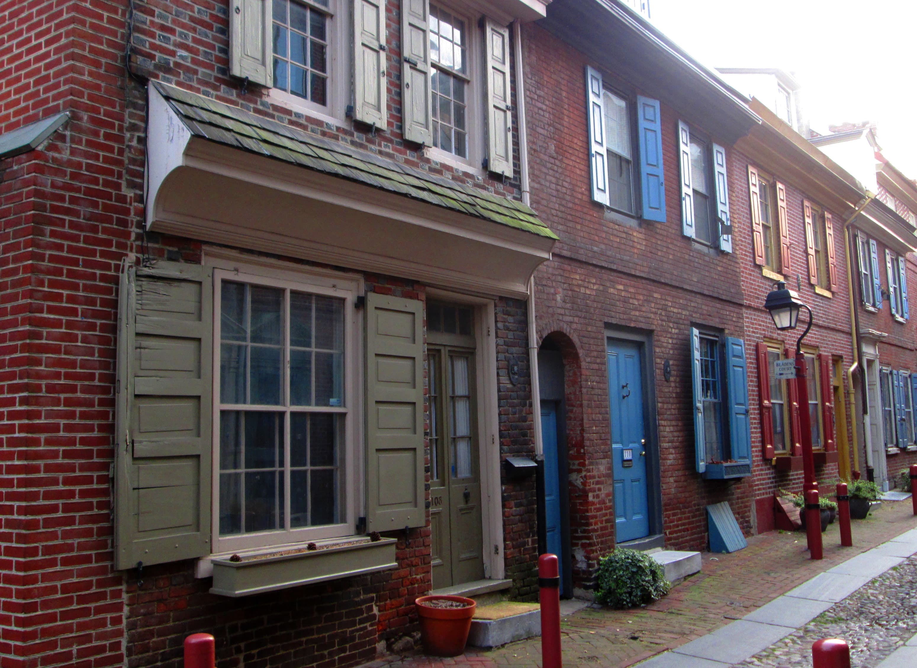
What unifies the district is not a boundary but a surface. Old City is a brick neighborhood, and its brickwork rewards a close look. The 18th-century rowhouses are built in Flemish bond — alternating headers and stretchers in each course — with glazed headers that give the walls a checkerboard shimmer. Windows are tall and shuttered, doors are paneled and often painted in deep colors, and many houses carry the small angled mirrors called busybodies at their upper windows, a Philadelphia detail that let residents watch the street without being seen. The scale is the point: three stories, sometimes four, built to the sidewalk line, so that the street feels like a room with brick walls. Later centuries added their own layers — 19th-century cast-iron storefronts, early-20th-century warehouses, a few modern insertions — but the street wall holds, and that continuity is what makes a walk here feel like time travel rather than a theme park.
Underfoot, the district keeps its old pavements where it can. Elfreth's Alley, the narrow block between Front and 2nd Streets, is the most famous cobbled street in the city, and its stones are genuinely old in feel, even where they have been reset. Second Street, Arch Street, and the cross streets keep stretches of cobblestone and Belgian block — the rectangular granite setts that paved the industrial city — alongside brick sidewalks and granite curbs. Wear good shoes: the charm of these surfaces is real, and so is their unevenness, especially after rain. The district's best experience is not a checklist but a pace — slow enough to look up at cornices and down at doorsteps, to notice the datestones, the boot scrapers, the ghost signs painted on warehouse walls.
The architecture: rowhouses, banks, and the Exchange
Old City's architecture is a timeline you can walk. The earliest surviving layer is domestic and Georgian: the small brick rowhouses of the 18th century, built for artisans and merchants, with simple facades, paneled doors, and six-over-six sash windows. Elfreth's Alley is the purest surviving run of this layer — 32 houses built between the early 1700s and 1836, once the homes of blacksmiths, pewterers, and dressmakers, still lived in today — but the same fabric appears all over the district, on Arch, Cherry, and the side streets, often with a shop or studio at ground level now. The next layer is Federal and Greek Revival, the architecture of a confident new republic: the First Bank of the United States on South 3rd Street, built in the 1790s with a marble portico that announced the new nation's financial ambitions, and its successor, the Second Bank of the United States on Chestnut Street, designed by William Strickland and built in the 1820s, a marble temple to commerce that still dominates its block.
The district's architectural masterpiece, and the building that best explains what Old City was for, is the Merchants' Exchange on the triangular lot bounded by Dock, 3rd, and Walnut Streets. Designed by Strickland and built between 1832 and 1834, it is a Greek Revival building with a semicircular colonnade on its curved eastern front, a lantern-topped cupola, and a great domed exchange room inside where brokers once traded stocks and commodities, read the latest shipping news, and gathered the commercial intelligence of a port city. It is the oldest existing stock exchange building in the United States, was declared a National Historic Landmark in 2001, and now serves as the headquarters of Independence National Historical Park. Its exterior is the thing to see — the curved colonnade against the cobbles of Dock Street is one of the great set pieces of American architecture — and it anchors the southern end of the district's commercial story, where the counting houses gave way to the banks and exchanges of the 19th century.
Two more buildings complete the architectural walk, and both sit within a few minutes of the Exchange. The Philadelphia Bourse, at 13 South 5th Street, is a Beaux-Arts pile built in 1893–1895 to designs by G. W. and W. D. Hewitt, one of the city's first steel-framed buildings, raised by grain and commodities merchants who modeled their exchange on the bourses of Hamburg and Paris. Its red stone and buff brick facade, its great interior hall, and its later life as a food hall and office building tell the story of Old City's second commercial century — the shift from sail to steel, from counting house to corporation. And on 2nd Street, Christ Church, built between 1727 and 1744 with a steeple added in the 1750s, is the district's great ecclesiastical landmark: a Georgian church with a Palladian window, box pews, and a congregation that once included Franklin, Washington, and other founders, standing at the corner where the neighborhood's religious, commercial, and political lives crossed. Its burial ground, two blocks west on Arch Street, holds Franklin's grave and is one of the most visited small spaces in the city — worth a pause, not a detour, on a district walk.
Market streets: from High Street to Headhouse Square
Philadelphia was fed by its markets, and Old City was where the markets stood. The original city market ran down the middle of High Street — Market Street — in open sheds where farmers sold produce, butchers sold meat, and fishmongers sold the Delaware's catch. As the city grew, the markets multiplied and moved: the High Street sheds were eventually cleared, but the market tradition moved south to Second Street, where the New Market was established in 1745 to serve the growing neighborhoods south of the original city. The Second Street market grew into a long run of open sheds — the "shambles" — with a head house at each end, and it is that market, in its surviving northern portion, that visitors know today as Headhouse Square.
Here an honest bit of geography matters. Headhouse Square itself — the Georgian brick firehouse with its cupola and clock, built at the north end of the market in 1804 with money lent by the merchant Joseph Wetherill, and the covered market sheds behind it on South 2nd Street between Pine and Lombard — sits just south of Walnut Street, which means it sits just outside the Old City frame used in this article, in the neighboring district of Society Hill. It belongs in this article anyway, for two reasons. First, it is a ten-minute walk down Second Street from the heart of Old City, and no honest walk of the district's market history ends at an invisible line on Walnut. Second, it is the living continuation of the market story: the Head House is described as the oldest surviving firehouse building in the United States, the market sheds still shelter vendors, and a farmers market still trades there on Sundays, in a tradition that runs back to the 18th century. Treat Headhouse Square as the southern extension of the Old City walk, not as a separate trip — walk south on 2nd, cross Walnut, and the cobbles and the sheds will tell you that you have arrived.
The market story also explains the district's street pattern. Second Street was the commercial street of the early city — the place where the shops, taverns, and workshops clustered between the waterfront and the residential blocks — and it still carries that mixed character: galleries and boutiques beside restaurants, old tavern buildings beside new storefronts. Market Street, meanwhile, kept its role as the city's great east-west artery, and the blocks of Market between Front and 6th still mix the monumental (the Mint, the Federal Reserve, the approach to the Benjamin Franklin Bridge) with the everyday (delis, shops, and the foot traffic of a downtown). To walk Old City is to walk the city's original supply chain: from the river wharves, up the market streets, to the tables of the city.
The anchors, in passing
A district article has to name the famous rooms without retelling them, and Old City's famous rooms are the most famous in the country. Independence Hall, at Chestnut between 5th and 6th, is the red-brick Georgian building with the clock tower where the Declaration and the Constitution were signed; its west wing, Congress Hall, housed Congress when Philadelphia was the capital. The Liberty Bell hangs in its glass pavilion across Chestnut Street, on the Mall, and draws a line of visitors in every season. Both are administered as part of Independence National Historical Park, and both are covered in full in their own articles in this journal — go to them early in the day, expect lines and security screening, and then come back to the neighborhood streets, which are the part of the story that stays with you.
Two more anchors sit on the district's northern streets, and they are best taken as part of the street walk rather than as separate expeditions. The Betsy Ross House, on Arch Street between 2nd and 3rd, is the small brick house where, according to tradition, Betsy Ross sewed the first American flag; the house and its courtyard are covered in their own article, and the point here is the street it stands on — Arch Street, with its meeting house, its burial ground, and its rowhouses, is one of the finest historic streetscapes in the city. Elfreth's Alley, a block north and east, is the district's most photographed street and its most residential: 32 houses, still lived in, on a narrow cobbled lane that was opened in the early 1700s as a cart path to the river. Walk it slowly, speak quietly, and remember that the flower boxes and painted doors belong to people who live there. The alley is the district in miniature — working-class houses, not mansions, preserved because residents fought for them in the 1930s when the city planned to clear the block.
There are smaller anchors worth a glance as you pass: Carpenters' Hall on Chestnut, the Georgian hall of the Carpenters' Company where the First Continental Congress met in 1774; the Arch Street Friends Meeting House, the Quaker meeting house that has stood on Arch Street since the early 19th century on a site used by Friends since the 1690s; and Franklin Court, the archaeological site and museum on Market Street where Franklin's house once stood. None of these needs a full stop on a district walk. All of them reward a pause, a look up, and a note to come back.
First Friday and the 3rd Street galleries
Old City's second life — the one that saved it from becoming a purely historic district — began with artists. In the 1970s and 1980s, when the neighborhood's warehouses and upper floors were cheap and its historic fabric was unfashionable, painters, sculptors, and photographers moved into the big loft spaces, and galleries followed them. By the 1990s, Old City had the densest gallery scene in Philadelphia, and it invented the ritual that still defines its cultural calendar: First Friday. On the first Friday evening of each month, the galleries between Front and 3rd Streets, Vine and Market, open their doors for new exhibitions, and the streets fill with people moving from show to show, talking to artists, and spilling into the restaurants and bars afterward. The galleries are not a single style — painting, photography, sculpture, craft, and new media share the corridor — and the point of First Friday is not any one show but the crawl itself: the pleasure of walking a historic district at night, with the doors open.
The gallery corridor has a spine, and it is 3rd Street. The 3rd Street Corridor, running from Chestnut Street north to Vine, is the district's premier shopping and gallery row: more than two dozen independently owned boutiques, design showrooms, craft studios, and galleries in converted warehouses and rowhouses, selling everything from contemporary furniture and studio jewelry to fine art and handmade goods. The Museum for Art in Wood, on Vine Street at the corridor's northern end, is the corridor's anchor institution — a museum and workshop dedicated to wood as an artistic medium, with exhibitions and a permanent collection that draw makers from around the country. The corridor rewards the same slow pace as the historic streets: the shopfronts are small, the stock changes often, and the best finds are the ones you were not looking for.
The arts scene is also the reason Old City feels lived-in rather than preserved. The galleries brought foot traffic, the foot traffic brought restaurants, and the restaurants brought residents back to the upper floors. The district's preservation — the 2003 historic district designation, the careful restoration of facades, the resistance to demolitions — happened alongside its reinvention, not instead of it. That tension, between the 18th century and the present, is the neighborhood's real subject, and it is visible on every block: a gallery in a former sail-maker's loft, a restaurant in a former bank, a boutique in a rowhouse that once held a chair-maker's shop.
Tables, bars, and the night the district changes hands
Old City eats and drinks the way it has always done — well, and late. The district's tavern tradition runs back to the 18th century, when City Tavern, built by subscription in 1773 on 2nd Street, served as the unofficial clubhouse of the Continental Congress, and the taverns and coffee houses of the waterfront served sailors, merchants, and politicians alike. The modern district keeps that tradition in a different key: the ground floors of the rowhouses and warehouses hold restaurants of nearly every description, from white-tablecloth dining rooms to casual BYOBs, wine bars, and late-night rooms, and the side streets fill on weekend evenings with a young, professional crowd moving between dinner and drinks. The neighborhood's restaurant-supply trade, clustered in the same blocks, is a reminder that this is still a working food district, not just a dining one.
The honest way to eat in Old City is to let the walk decide. The district is compact enough that no restaurant is more than a few minutes from any other, and the best meals here are often the unplanned ones — a table found after a gallery crawl, a bar discovered on a side street, a late supper after a show. The long-standing rooms have their followings, and the new rooms turn over with the seasons, so this article names no single table as a must: the district's dining scene is a moving target by design, and a guide that names names will be out of date before it is printed. What does not change is the setting — brick walls, low ceilings, candlelight in rooms that have served food and drink for decades or centuries — and the feeling, on a Friday night, that the neighborhood has changed hands from its daytime visitors to its nighttime residents.
That nighttime character is worth a note for first-time visitors. Old City by day is a historic district, with school groups, tour groups, and families on the Mall. Old City by night is a neighborhood, with gallery crowds, dinner crowds, and bar crowds sharing the same cobbles. Both are the real district, and the best visit takes in both: the historic streets in the morning light, when the brick is warm and the crowds are thin, and the same streets after dark, when the gallery windows are lit and the restaurants are full. If you only see one version, you have only seen half the neighborhood.
The river edge: Penn's Landing and the Delaware
Every Old City walk should end at the water, because the water is why the city is here. Penn's Landing, the waterfront district along the Delaware between Front Street and the river, is the modern name for the landing place at the foot of Market Street, where Penn's city met its port. The name is commemorative rather than literal — Penn himself first came ashore farther south, at New Castle and then Chester, before reaching the site of his new city — but the place is real enough: a broad esplanade along Christopher Columbus Boulevard (Delaware Avenue), with the Great Plaza at Chestnut Street, the Independence Seaport Museum and its historic ships, and the long views across the river to Camden, New Jersey. The Benjamin Franklin Bridge, opened in 1926, spans the river just north of the district, its steel towers visible from almost every waterfront corner, and the RiverLink ferry crosses to the Camden waterfront, where the battleship New Jersey is moored.
The waterfront's history is a story of separation and return. In the 18th and early 19th centuries, the wharves ran right up to Front Street, and the district's merchants could watch their ships from their counting-house windows. The railroad and then Interstate 95, which runs along the river's edge on a raised highway, cut the neighborhood off from its waterfront for much of the 20th century, and Penn's Landing itself is largely landfill, created in the early 1960s on ground that was once river. The recent decades have been a slow reconnection: the Race Street Pier, built on the site of a municipal pier from 1896, is now a public park with lawns and a grand staircase to the water, offering views of the bridge and the skyline; the Great Plaza hosts concerts and festivals in the warm months; and the Delaware River Waterfront Corporation, the nonprofit that manages the central waterfront, has been rebuilding the edge piece by piece, with new parks and trails filling the gaps between the highway and the river.
Stand at the Race Street Pier at dusk and the district's story comes together. Behind you are the brick streets, the market sheds, the galleries, and the rooms where the founding documents were signed. In front of you is the river that brought the settlers, the merchants, the immigrants, and the goods that made the city — wide, brown, tidal, and still working, with tugs and tankers passing the pleasure boats. Old City is a river neighborhood that spent a century turned away from its river, and is now turning back. The walk from the Mall to the water, from the State House to the pier, is the shortest history of Philadelphia there is.
A walking route through the district
Old City is best walked as a loop, and the loop below takes about two hours at a strolling pace, longer if you stop in galleries, shops, and museums along the way. It is designed to link the district's anchors without retelling their stories — the landmark articles cover those — and to keep you on the streets that make the district a district.
Start at 2nd and Market Streets, at the foot of the old High Street, and walk north on 2nd to Arch Street. Turn east on Arch past the Betsy Ross House block and the Arch Street Meeting House, then north to Elfreth's Alley: walk the alley from 2nd to Front Street, slowly, and remember that people live in these houses. From Front Street, turn south and walk the waterfront edge to Market Street, then west on Market past Franklin Court to the Mall. Pause at the Mall's edge — Independence Hall and the Liberty Bell pavilion are here, and their articles tell their stories — but do not let the Mall swallow the walk: turn south on 5th or 6th Street to Chestnut, then east on Chestnut past Carpenters' Hall and the Second Bank to 3rd Street.
Turn south on 3rd Street, the gallery corridor, and walk it slowly: the boutiques and galleries between Chestnut and Walnut are the district's present tense. At Walnut, turn east to Dock Street and the Merchants' Exchange, and stand for a moment in front of its curved colonnade. Then continue south on 2nd Street, crossing Walnut into Society Hill, to Headhouse Square: the firehouse, the market sheds, and the cobbles of the 400 block of South 2nd. From Headhouse, walk east to the waterfront at Penn's Landing — the Great Plaza, the Seaport Museum, the river — and then north along the riverfront to the Race Street Pier. Finish by walking west on Race or Arch back into the heart of the district, for a gallery, a meal, or a drink. You will have walked Penn's grid, the market streets, the gallery corridor, and the river edge, and you will have seen the district whole.
How to visit, and what to check before you go
Old City is a public neighborhood, not a ticketed attraction: its streets, its shopfronts, and its waterfront parks are open to walk at any hour, and most of its pleasures — the brickwork, the cobbles, the gallery windows, the river views — cost nothing. The individual sites within and beside the district set their own arrangements: Independence Hall, the Liberty Bell, the Betsy Ross House, and the museums keep their own schedules, and the galleries keep their own hours, with First Friday evenings the best bet for finding the most doors open. No fixed price, fee, or opening hour is stated in this article, since none was verified against an official source in this run — check the official sources for Independence National Historical Park, the individual museums, and the Old City District's own listings before visiting for current hours, prices, and schedules, and check the galleries' listings for First Friday dates.
Come on foot, and come early if you want the historic streets to yourself: the Mall and the famous rooms draw crowds by mid-morning, while the side streets stay quiet until the galleries and restaurants open. Wear shoes that can handle cobblestone and Belgian block, bring water in warm weather, and be ready for a neighborhood that rewards looking up — at steeples, cornices, and cupolas — and looking down — at datestones, boot scrapers, and the worn thresholds of three hundred years of doorways. Pair the walk with the rest of the waterfront: the Benjamin Franklin Bridge walkway for the river view, the Camden ferry for the skyline from the other side, or a southward stroll into Society Hill, whose own brick streets continue the story where Old City leaves off. And remember the district's simplest rule, the one its residents ask of every visitor: walk softly on the residential streets, speak quietly in the alley, and treat the neighborhood as a place where people live — because that, more than any single landmark, is what has kept Old City alive for three centuries.
Location Photography


Key Facts
Old City is Philadelphia's oldest neighborhood, laid out in William Penn's 1682 plan (drawn by surveyor Thomas Holme in 1683) as a grid between the Delaware and Schuylkill rivers, with High Street (now Market Street) as its great east-west axis and Broad Street running north-south.
The district's working frame is roughly Front Street on the east to 6th Street on the west, Vine Street on the north to Walnut Street on the south; tighter definitions draw the west line at 4th Street and the north line at Race Street. The Philadelphia Historical Commission designated the Old City Historic District in 2003.
Old City bills itself as the nation's most historic square mile. The claim rests on the concentration of founding-era sites in and beside the district: Independence Hall (Declaration of Independence 1776, Constitution 1787), Congress Hall, Carpenters' Hall (First Continental Congress 1774), and the Liberty Bell pavilion on Independence Mall.
The land was Lenapehoking, homeland of the Lenape, before Penn's colony; Swedish and Dutch settlers preceded the English proprietary colony in the Delaware Valley.
Elfreth's Alley, between Front and 2nd Streets, is a narrow cobbled lane opened in the early 1700s as a cart path to the river, with 32 houses built between the early 1700s and 1836, still lived in today; residents fought off clearance plans in the 1930s and the alley is a National Historic Landmark.
The Betsy Ross House stands on Arch Street between 2nd and 3rd; Christ Church (built 1727–1744, steeple added in the 1750s) stands on 2nd Street, and its burial ground on Arch Street holds Benjamin Franklin's grave. Each anchor is covered in its own journal article and is mentioned here only in passing.
The Merchants' Exchange, on the triangular lot bounded by Dock, 3rd, and Walnut Streets, was designed by William Strickland and built 1832–1834 in the Greek Revival style, with a semicircular colonnade and a domed exchange room; it is the oldest existing stock exchange building in the United States, was declared a National Historic Landmark in 2001, and now serves as headquarters of Independence National Historical Park.
The First Bank of the United States (South 3rd Street, 1790s) and the Second Bank of the United States (Chestnut Street, designed by Strickland, 1820s) are the district's great early-republic bank buildings.
The Philadelphia Bourse, at 13 South 5th Street, was built 1893–1895 to designs by G. W. and W. D. Hewitt in the Beaux-Arts style, one of the city's first steel-framed buildings, for grain and commodities merchants modeled on the Hamburg bourse; it later housed a food hall and offices.
The city's markets ran down the middle of High Street (Market Street) in open sheds; the New Market on Second Street was established in 1745 and survives as Headhouse Square — the Georgian brick Head House built in 1804 at the north end of the market, with covered sheds behind it on South 2nd Street between Pine and Lombard. Headhouse Square sits just south of Walnut Street, in Society Hill, and is the southern extension of the Old City market walk; its Head House is described as the oldest surviving firehouse building in the United States, and a farmers market still trades there on Sundays.
The 3rd Street Corridor, from Chestnut Street north to Vine, is the district's gallery and boutique row, with more than two dozen independently owned shops and galleries; the Museum for Art in Wood stands at its northern end. On the first Friday evening of each month, the district's galleries open their doors for new exhibitions in the First Friday crawl, concentrated between Front and 3rd Streets, Vine and Market.
Old City's tavern tradition runs back to City Tavern, built by subscription in 1773 on 2nd Street; the modern district's ground floors hold restaurants, wine bars, and late-night rooms, and the side streets fill on weekend evenings.
Penn's Landing is the waterfront district along the Delaware at the foot of Market Street, named for William Penn's landing (Penn himself first came ashore farther south, at New Castle and Chester); its Great Plaza sits at Chestnut Street, the Independence Seaport Museum and its historic ships stand on the waterfront, and the RiverLink ferry crosses to Camden. The Benjamin Franklin Bridge, opened in 1926, spans the river just north of the district. Penn's Landing itself is largely landfill created in the early 1960s; Interstate 95 along the river's edge cut the neighborhood from its waterfront for much of the 20th century.
The Race Street Pier, on the site of a municipal pier built in 1896, is now a public park with lawns and a staircase to the water, with views of the Benjamin Franklin Bridge and the skyline.
The district's streets keep stretches of cobblestone and Belgian block, notably on Elfreth's Alley, Second Street, and Arch Street, alongside Flemish-bond brick rowhouses with shuttered windows, paneled doors, and busybody mirrors at upper windows.