A crossing built for water
Crossing High Bridge, you are following a route that once mattered to almost every household in Manhattan. The original traveler here was water. The walkway belongs to the Old Croton Aqueduct, the system that brought a distant supply into a growing city, and its surviving pipes help explain why this unusually graceful crossing exists.
Today the experience is more immediate: leave the streets of Washington Heights or the Bronx’s Highbridge neighborhood and find a public route above the Harlem River. The bridge invites a slower kind of looking than a road crossing. Pause without blocking others, turn toward the river, and consider how much engineering has been absorbed into the everyday landscape.
Its age is part of the attraction, but its purpose is the better starting point. The city’s oldest surviving bridge was not built to carry cars. Understanding that single difference changes the visit from a search for an impressive view into a walk through the history of New York’s basic needs.
The thirst that built it
New York built the aqueduct because it was running out of options. An 1832 cholera outbreak had killed thousands, and during the Great Fire of 1835 there was not enough water to fight the flames. The city's wells and cisterns were depleted and polluted. In April 1835, voters approved the Croton Aqueduct by 17,330 to 5,963. John B. Jervis was chosen as chief engineer the following year, and construction began in 1837 with a workforce of nearly 4,000 immigrants digging and laying 41 miles of masonry conduit. The water arrived by gravity — a 22-hour, 41-mile journey — on July 4, 1842, and the official celebration came on October 14, with a parade and a fountain in City Hall Park throwing water 50 feet into the air. The project cost just under $9 million. It took six more years to get the water across the Harlem River: Jervis had originally proposed a low bridge or even an inverted siphon, but property owners who hoped ships would one day reach upriver insisted on a tall crossing. Water began flowing across High Bridge in May 1848, through twin three-foot cast-iron pipes. A third tube and the pedestrian walkway were added in the early 1860s.
Nearly demolished, then saved
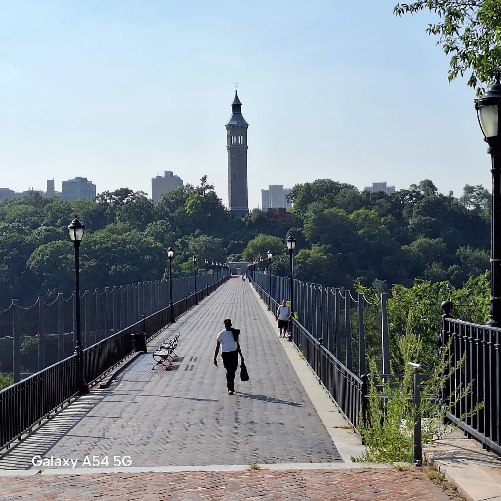
The bridge stopped being essential long before it stopped being used. It was decommissioned as an aqueduct in 1917, and by the 1920s the city wanted it gone as a hazard to navigation on the Harlem River: in 1923, the government approved demolition. A Scientific American editorial called the plan "an act of vandalism without precedent in the history of our country." The compromise — five of the fifteen masonry arches replaced with a single steel arch, giving ships 360 feet of clearance — was completed in 1927. The bridge limped on. Children threw rocks at a passing Circle Line tour boat in the late 1950s. Water stopped flowing across it in 1958, and by 1970 the bridge was closed to the public. The rescue took decades of advocacy and $61 million. Restoration began in 2013 and the bridge reopened to walkers and cyclists on June 9, 2015 — 45 years after it closed. The Manhattan end still holds the Highbridge Water Tower, built in 1872 to boost pressure for the growing heights of Washington Heights. Its 47,000-gallon tank sits 200 feet above sea level; the tower was shut down during World War I over sabotage fears and retired in 1949. It has since been restored for tours — a reminder that the whole crossing was, first and last, about water.
Structure & Reopening
- Opened in 1848, making it the oldest existing bridge in all five boroughs of New York City.
- In the 1920s, several central stone arches were replaced by a single steel arch to facilitate maritime navigation.
- Closed to the public for more than 40 years before a major restoration led to its reopening for walkers and cyclists in 2015.
An aqueduct with two eras of arches
Chief aqueduct engineer John B. Jervis designed the original masonry crossing in the tradition of Roman aqueducts. Friends of the Old Croton Aqueduct records fifteen arches and completion in 1848, six years after the aqueduct system opened. Temporary low-level pipes carried water across the river in the intervening years.
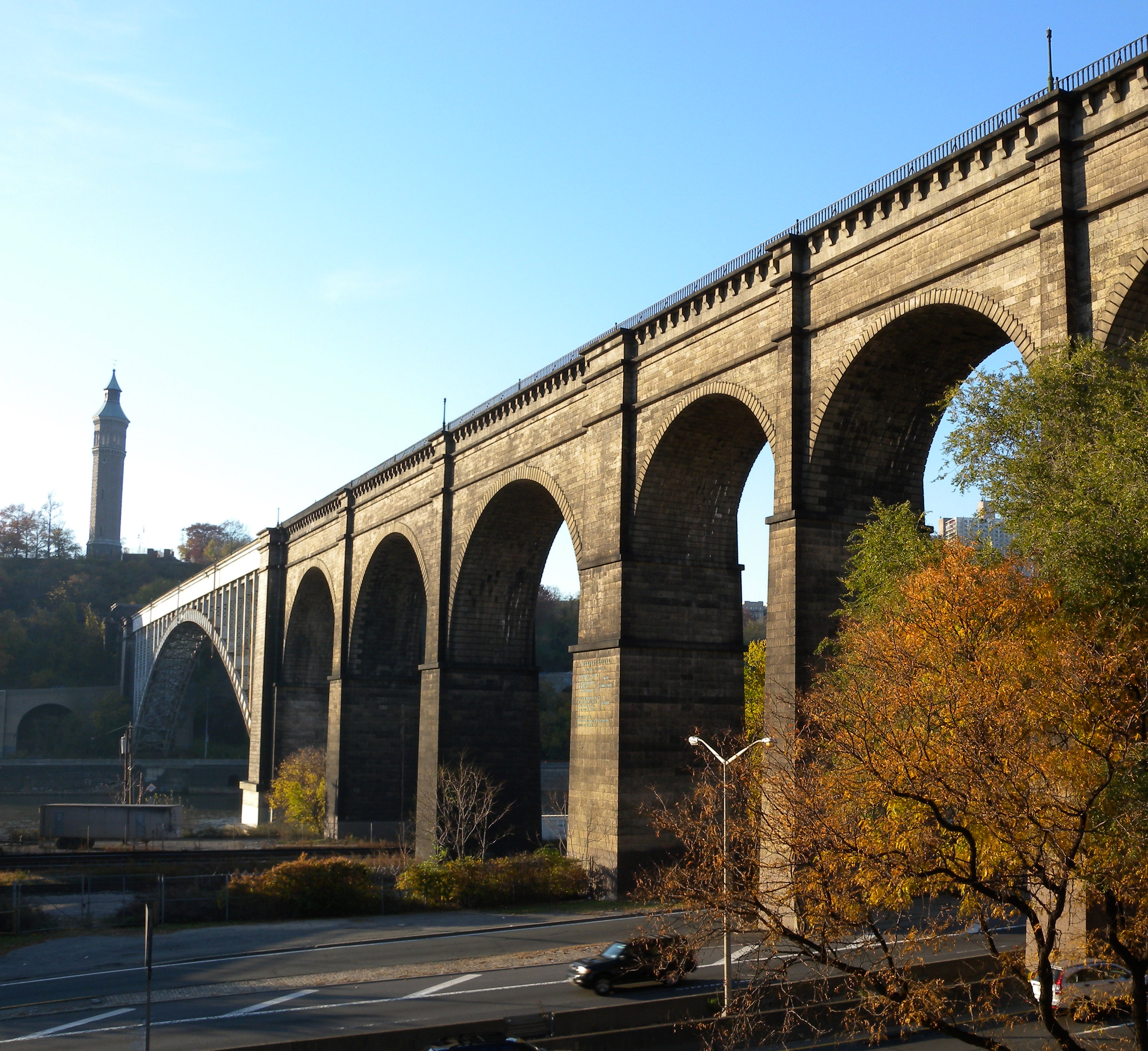
The structure you see is not entirely the one Jervis designed. In 1927–28, five masonry arches were replaced by a single steel arch to improve navigation. That combination makes the bridge especially useful to study: an older arrangement of stone supports survives alongside a later solution to a changing river’s requirements.
Rather than treating the steel as an interruption, read the two materials as different chapters. Infrastructure can survive through adaptation, and High Bridge makes that process visible. From a viewpoint where the side of the bridge is clear, compare the rhythm of the remaining stone arches with the wider opening of the steel span. Never leave designated paths or enter restricted areas to obtain that view.
Restoring a public connection
High Bridge reopened to the public in 2015 after decades of closure. NYC’s Department of Design and Construction describes the restoration as a balance between structural improvements and historic character. Its account highlights red bricks laid in a herringbone pattern with natural cement, work on the Manhattan gatehouse, and restoration of aqueduct piping over the steel span.
These are details to look for while walking. The paving is more than a background for photographs: its pattern contributes to the sense that the promenade is a continuous place, not merely a narrow route between banks. Look down as well as outward, and notice how small construction choices affect the experience of a large structure.
The restoration received the International Bridge Conference’s Abba G. Lichtenstein Medal, announced by DDC in 2017. Awards are only one way of assessing the project. For visitors, the practical achievement is easier to measure: a former barrier in the park system once again supports a journey between two neighborhoods.
Our featured photograph looks west from the Bronx side in September 2024. It records a modern visit, not the original aqueduct’s construction.
Planning the walk
Choose your approach before traveling, particularly if you need to avoid stairs. Friends of the Old Croton Aqueduct describes street-level entry from the Bronx near West 170th Street and University Avenue. On the Manhattan side, its route guidance distinguishes the stair approach near West 172nd Street and Amsterdam Avenue from the longer paved approach beginning around West 167th Street and Edgecombe Avenue.
Check current NYC Parks notices before setting out. Historic route descriptions are helpful for orientation, but temporary closures and path conditions can change. Verify subway service, elevators, and the complete route from your station with the MTA if step-free travel is essential. A bridge accessible to wheeled visitors does not make every nearby park entrance accessible.
This is a free park crossing. Plan for daylight, comfortable shoes, and the possibility of wind above the river. Leave room for other walkers and cyclists and follow posted rules. Allow time for the approaches as well as the span: the surrounding park is part of the journey, not simply the distance between the subway and the photograph.
For another chapter of northern Manhattan’s infrastructure, read our Manhattan Valley Viaduct story. For a different transformation of transport infrastructure into public space, explore the High Line Spur guide.
Manhattan Valley Viaduct: https://plain-sight-jade.vercel.app/places/united-states/new-york/manhattan-valley-viaduct
High Line Spur: https://plain-sight-jade.vercel.app/places/united-states/new-york/high-line-spur
Sources and photograph
NYC Department of Design and Construction: https://www.nyc.gov/site/ddc/about/press-releases/2017/pr-033017-high-bridge.page
Friends of the Old Croton Aqueduct, history and approaches: https://aqueduct.org/venue/high-bridge/
Photograph: Ronavni, September 13, 2024, CC BY-SA 4.0. Source: https://commons.wikimedia.org/wiki/File:The_High_Bridge_-_Looking_Westward_from_the_Bronx_side.jpg
Resized/WebP conversion; image remains licensed under https://creativecommons.org/licenses/by-sa/4.0/
Location Photography



Gallery photos: Jim.henderson (Public domain), Jim.henderson (CC0), Jim.henderson (Public domain), GaoKyle (CC BY-SA 4.0) via Wikimedia Commons.