
The island at the end of the causeway
The drive to Key Biscayne is part of the experience, and it tells you what kind of place this is. From downtown Miami, the Rickenbacker Causeway — named for World War I flying ace Eddie Rickenbacker — arcs across Biscayne Bay, crosses Virginia Key, and climbs a high bridge over the water before dropping onto a low, green island. The causeway opened in November 1947, and before it existed, Key Biscayne was effectively cut off from the mainland: reachable only by boat, a place of plantations, a lighthouse, and almost no one else. The road changed everything, and it changed it fast — within a few years the island went from isolated outpost to suburb, and the fight over what it would become has shaped it ever since.
Key Biscayne is a barrier island, a long strip of sand between the Atlantic Ocean on its eastern side and Biscayne Bay on its western side, just south of Miami Beach and east of downtown Miami. It is the southernmost sand barrier island in the continental United States, and it is not part of the Florida Keys — a distinction locals will happily correct. The island divides roughly into thirds, and each third has a different character. The northern third is county parkland. The middle third is the Village of Key Biscayne, a residential community of condominiums, low-rise homes, and a compact village center along Crandon Boulevard. The southern third is Bill Baggs Cape Florida State Park, the wild end of the island, where the road ends at a lighthouse. This article is about the island as a whole — the village, the causeway crossing, and above all the lighthouse and the park at the tip — with the northern county park mentioned only in passing, since it is a story of its own.
The island's recorded history is among the longest in North America. The Tequesta people lived here long before Europeans arrived, fishing the bay and the reef. Spanish explorers knew the island as Cayo Vizcaíno, and tradition holds it was named for a Biscayne sailor shipwrecked on the Florida coast. Juan Ponce de León's expedition passed this shore in 1513, and the cape at the island's southern tip gave the whole region one of its earliest European names: the Cape of Florida. For three centuries the island stayed nearly empty — too exposed, too hard to reach, too far from any town — and that emptiness is exactly what preserved the lighthouse story at its tip.
A lighthouse older than Miami
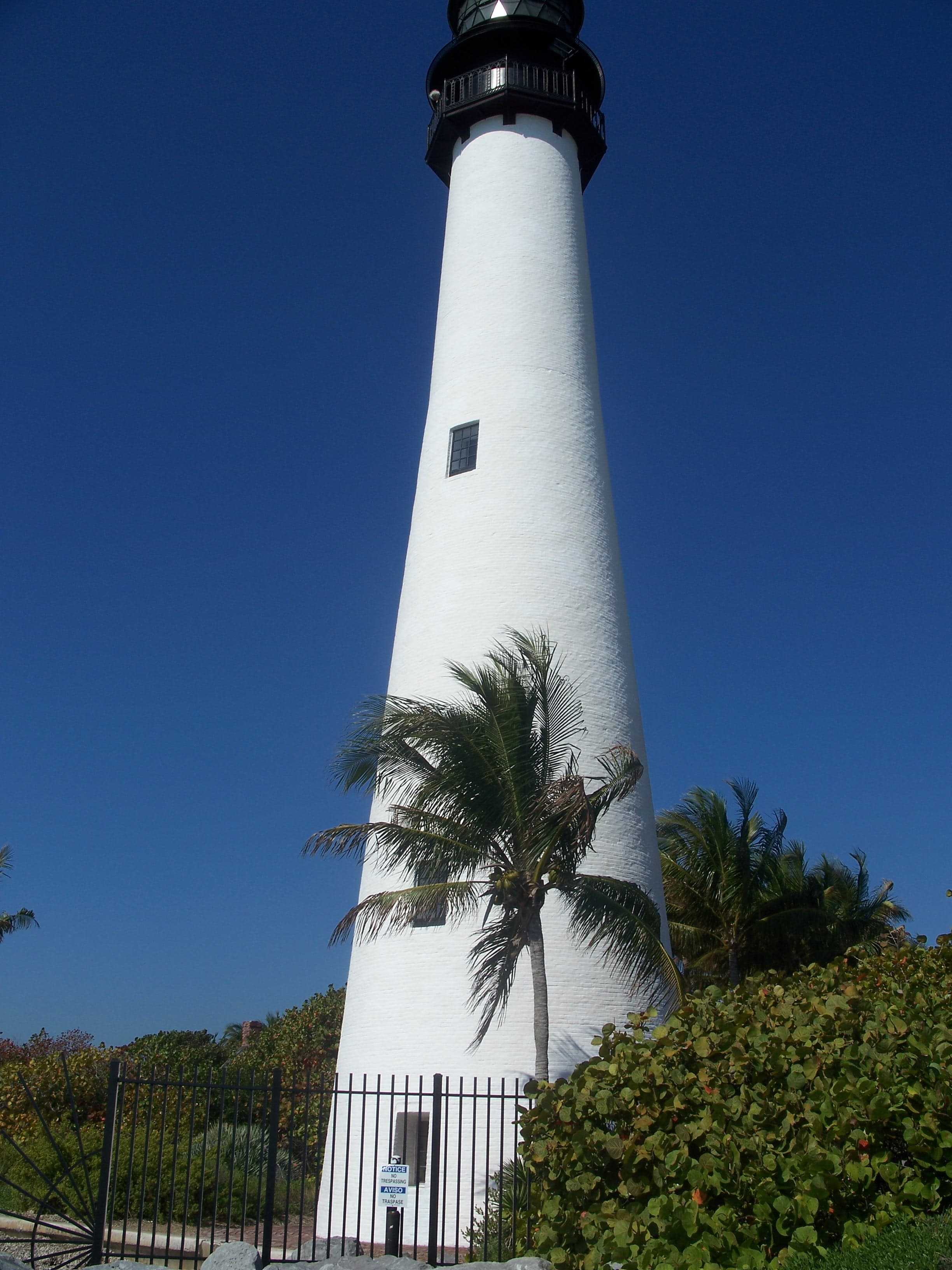
The Cape Florida Lighthouse is the oldest standing structure in Miami-Dade County, and it predates the City of Miami itself by more than seventy years. It was completed in 1825, when Florida had been an American territory for only four years and Miami did not exist at all. The federal government built it to guide ships past the Florida Reef, a treacherous coral barrier that begins near Key Biscayne and runs south past the Keys, and into the safe anchorage in the lee of the island. In the 1840s and 1850s, more than 500 ships were wrecked on that reef, and in the five years from 1845 to 1849 alone, nearly a million dollars' worth of vessels and cargo was lost there. The lighthouse was, from the start, a matter of life, death, and money.
The first tower was a troubled building. The contract called for a 65-foot tower of solid brick, five feet thick at the base tapering to two feet at the top. The contractor scrimped, building hollow walls instead, and the fraud was only discovered later. The first keeper, Captain John Dubose, served for more than a decade, and in 1835 a major hurricane damaged the tower and the keeper's house and flooded the island under three feet of water. But the lighthouse's most famous day came the following year, during the Second Seminole War.
On July 23, 1836, a band of Seminole warriors attacked the lighthouse station. The assistant keeper, John W. B. Thompson, and Aaron Carter, an African American man working at the station, fled into the tower and barricaded themselves inside. Thompson later wrote a vivid account of the siege: rifle balls cutting through his clothes and hat, the attackers setting fire to the door and a ground-floor window, oil from perforated lamp tanks — 225 gallons of it — catching fire and driving the two men to the top of the tower, where they lay on the two-foot-wide platform outside the lantern with their clothes burning. Thompson threw a keg of gunpowder down the tower hoping for a quick death; the explosion shook the tower but did not topple it. Carter died of his wounds and the fire. Thompson, his feet shot through with rifle balls and the stairway burned away beneath him, was trapped at the top until the U.S. Navy schooner Motto, which had heard the explosion from twelve miles away, came to investigate and, the next day, hauled him down with a rope. The Cape Florida Light was extinguished from 1836 to 1846, and it remains one of the very few American lighthouses ever attacked during a war.
The tower was rebuilt under a contract let in 1846, reusing the old bricks, and re-lit in April 1847. In 1855 it was raised to its present height of 95 feet and fitted with a second-order Fresnel lens brought to Cape Florida by Lt. Col. George Meade of the U.S. Army Corps of Topographical Engineers — the same Meade who would later command the Union army at Gettysburg. Confederate sympathizers destroyed the lamp and lens in 1861, during the Civil War; the light was repaired in 1866. In 1878 the lighthouse was decommissioned for good as an active coastal light, replaced by the screw-pile Fowey Rocks lighthouse seven miles to the southeast, which could warn ships away from the reef more effectively. The keepers moved with the job: John Frow and his father Simeon, the last keepers at Cape Florida, became the first keepers at Fowey Rocks.
The tower's afterlife is almost as colorful as its working life. From 1888 to 1893 it was leased to the Biscayne Bay Yacht Club for a total of one dollar — twenty cents a year — as its headquarters, billed as the southernmost yacht club in the United States and the tallest in the world. In 1898, as war with Spain loomed, it briefly served as U.S. Signal Station Number Four, one of 36 stations watching for the Spanish fleet. The land around it passed through private hands: Waters Davis bought the abandoned lighthouse from the Treasury in 1903 for $400, and in 1913 he sold his Key Biscayne property, including the lighthouse, to James Deering, the International Harvester heir who built the Vizcaya estate on the mainland. Deering, finding the tower's foundations only four feet deep and the beach eroding toward it, ordered sandbagging, jetties, and a new concrete-and-steel foundation; the tower survived the eyewall of the 1926 Miami Hurricane on that foundation. Beach erosion had already carried away a quarter mile of sand in front of the lighthouse in the ninety years since its construction, and at one point the tower stood almost in the surf.
The Saltwater Railroad
The lighthouse has a second history, darker and less often told, and the park marks it with a sign that visitors should not walk past. Before the lighthouse was built, Cape Florida was one of the places where enslaved people and Black Seminoles boarded boats for the Bahamas — a migration known as the Saltwater Railroad. Under Spanish rule, many Black people in Florida had been free, and when Spain transferred Florida to the United States in 1819, hundreds feared that freedom would end under American slavery. During the early 1820s an estimated 300 Black Seminoles found passage from Key Biscayne to Andros Island in the Bahamas in seagoing canoes and Bahamian boats; one traveler in 1820 reported seeing 60 Native people, 60 runaway slaves, and 27 boats of Bahamian wreckers preparing to leave Cape Florida. The lighthouse itself, when it was built, compromised the escape route: its bright light made night departures far more dangerous, and Cape Florida became less suitable as a departure point, though the Bahamas remained a haven.
In 2004 a large historical marker was erected in the park recognizing the site as part of the National Underground Railroad Network to Freedom, commemorating the hundreds of Black Seminoles and fugitive slaves who escaped from here to freedom in the Bahamas, settling mostly on Andros Island. The park is one of only two parks in Florida to hold that designation, the other being Fort Jefferson in the Dry Tortugas. Stand at the southern tip of the island, where the marker stands near the beach, and the geography of the story is suddenly plain: the Bahamas are the nearest freedom, 154 miles of open water away, and the people who left from this beach crossed it in canoes.
Bill Baggs and the park that almost wasn't
The southern third of Key Biscayne nearly became a housing development. In the 1950s, developers planned hotels, single-family homes, and condominiums across the Cape Florida property; they cut down nearly every tree on the site, including in the mangrove wetlands, and filled the land with dredged material to level it for construction. The man who stopped them was Bill Baggs, editor of The Miami News from 1957 until his death in 1969, a civil rights advocate who campaigned to keep the cape undeveloped and helped arrange the state's purchase. In 1966 the State of Florida bought the southern third of the island, including the lighthouse, and established Bill Baggs Cape Florida State Park, named for him. The park opened on January 1, 1967. Without Baggs, the tip of the island would very likely be another gated community today, and the lighthouse would be a decoration in a subdivision.
The park now covers roughly 400 acres, with more than 1.2 miles of sandy Atlantic beach and about 1.4 miles of shoreline fronting Biscayne Bay. Its beach has been ranked among the best in the country — eighth in the nation in 2005 and seventh by Forbes in 2013 — and the rankings are easy to understand on arrival: wide white sand, comparatively gentle surf sheltered in part by an offshore reef, and a view south down an undeveloped shoreline that ends at the lighthouse itself. The park's other landmark is No Name Harbor, a natural anchorage on the bay side where boats tie up, and from the top of the lighthouse, on a clear day, you can look across the bay to downtown Miami and south to the stilt houses of Stiltsville, the strange village of wooden houses standing on pilings in the shallows of Biscayne Bay. The state restored the lighthouse tower and built replicas of the keeper's dwellings in 1969 and 1970; the replica keeper's cottage now serves as a small museum of the island's maritime history. The Coast Guard returned the light to service in 1978, decommissioned it again in 1990, and after a joint restoration with the Dade County Historical Society in 1995–1996, the lighthouse was relit in time for Miami's centennial in July 1996. It was listed on the National Register of Historic Places in 1970.
Climbing the lighthouse is the park's signature experience, and it is not a casual one: the climb is 109 steps up a narrow spiral, and the tower is open to climbers only on ranger-led tours, not on a walk-in basis. From the gallery deck at the top, the reward is a full panorama — the Atlantic to the east, Biscayne Bay and the Miami skyline to the west, Stiltsville to the south, and the whole green length of the island to the north. The rest of the park is built for a slower day: a paved loop for cycling, nature trails through restored tropical hardwood hammock and mangroves, picnic areas, fishing from the seawall and the jetty, kayaking on the calm bay side, and the open-air Lighthouse Café near the beach and Boater's Grill at No Name Harbor. Hurricane Andrew in 1992 devastated the park's Australian pines, and the restoration that followed replanted hundreds of acres of native barrier-island vegetation — the hammock and coastal strand you walk through today are, in large part, a deliberate reconstruction of what the developers and the storm destroyed.
The village in the middle
Between the two parks sits the Village of Key Biscayne, and its history explains why the island feels the way it does: half resort, half small town, and fiercely protective of the balance. The northern two-thirds of the island were, in the first half of the twentieth century, the largest coconut plantation in the continental United States, owned by William John Matheson. In 1940 the Matheson heirs donated more than 800 acres at the island's north end to Dade County for a public park, in exchange for the county's commitment to build a causeway — the deal that made the Rickenbacker Causeway possible and, with it, the island's development. The Mackle Company built the village's first subdivisions in the 1950s, marketing modest concrete-block homes to veterans, and the Key Biscayne Hotel and Villas on the ocean became a celebrity and political haunt: it hosted the first meeting between John F. Kennedy and Richard Nixon after the 1960 election.
Nixon's connection to the island ran deeper than that meeting. In 1969 he purchased the first of several waterfront homes on Biscayne Bay, forming a compound with the houses of his friend Bebe Rebozo and industrialist Robert Abplanalp that became known as the Florida White House, or the Winter White House. He visited more than 50 times between 1969 and 1973, and as the Watergate scandal unfolded he spent increasing time in seclusion there. The compound is private property and not a visitor attraction, but its shadow over the island's history is part of why Key Biscayne feels different from any other Miami suburb: for five years, this quiet island was one of the centers of American political power.
The Village of Key Biscayne was incorporated in 1991, the first new municipality in Miami-Dade County in more than fifty years, precisely so residents could control taxes and future development — the same instinct that had saved the cape from developers a generation earlier. Today the village center along Crandon Boulevard has the everyday infrastructure of a small town: a grocery, cafes, a library, a community center, and the Village Green park, all within a few blocks. The island's pace is set by bicycles as much as by cars; the causeway has a dedicated path, and on weekend mornings the bridge fills with cyclists riding out to the lighthouse and back. That is the island's real signature, more than any single sight: a place five miles from downtown Miami that has chosen, twice — in 1966 and in 1991 — to stay low, green, and a little apart.
How to visit
Key Biscayne is reached only by road, and the only road is the Rickenbacker Causeway from the mainland via Virginia Key; there is no bridge from Miami Beach and no ferry for general visitors. The causeway is a toll road, and the state park at the island's southern tip charges an entry fee — no fixed toll or entry fee is stated in this article, since none was verified against an official source in this run, and both change over time. Check the official Florida State Parks page for Bill Baggs Cape Florida State Park before visiting for current entry fees, park hours, and the lighthouse tour schedule, since the tower is open to climbers only on ranger-led tours and tour days and times are limited. The park is generally open daily from morning until sunset, and the beach is unguarded in places, so swim with care and check conditions on arrival.
A good day on Key Biscayne starts early, before the causeway traffic builds: drive or cycle across the bridge, stop at the village center for coffee, then continue south on Crandon Boulevard until the road ends at Bill Baggs. Walk the beach to the lighthouse, take the ranger tour to the top, visit the keeper's cottage museum and the Network to Freedom marker, and have lunch at No Name Harbor before the afternoon crowds. Pair the island with the mainland sights it connects to: the Vizcaya estate whose owner once owned the lighthouse, or the Miami Seaquarium on Virginia Key, passed on the causeway crossing. And take the long view the lighthouse offers, in both directions: to the north, the skyline of the city that grew up after the tower was built, and to the south, the open water toward the Bahamas that made this cape, for a few desperate years, a gateway to freedom.
Key Facts
- Key Biscayne is a barrier island in Miami-Dade County between the Atlantic and Biscayne Bay, the southernmost sand barrier island in the continental United States, and it is not part of the Florida Keys. The island divides roughly into thirds: county parkland north, the Village of Key Biscayne center, and Bill Baggs Cape Florida State Park south; Crandon Boulevard runs about five miles through the island.
- Spanish name Cayo Vizcaíno; the Tequesta inhabited it before European contact; Ponce de León's expedition passed the cape in 1513. The Rickenbacker Causeway, named for Eddie Rickenbacker, opened in November 1947; before it the island was reachable only by boat. The northern two-thirds were the largest coconut plantation in the continental U.S., owned by William John Matheson; in 1940 the Matheson heirs donated 800+ acres for a county park in exchange for the causeway commitment.
- Cape Florida Lighthouse completed 1825 as a 65-foot tower (hollow-wall fraud); first keeper Captain John Dubose; 1835 hurricane flooded the island under three feet of water. On July 23, 1836, Seminole warriors attacked: Thompson and Carter barricaded in the tower, Carter died, and Thompson was rescued the next day by the Navy schooner Motto; the light was out 1836–1846.
- Rebuilt and re-lit April 1847; raised to 95 feet in 1855 with a second-order Fresnel lens via Lt. Col. George Meade; lamp destroyed 1861, repaired 1866; decommissioned 1878 for Fowey Rocks, seven miles southeast. Leased to the Biscayne Bay Yacht Club 1888–1893 for one dollar total; Signal Station Number Four in 1898; Waters Davis bought it in 1903 for $400, sold to James Deering in 1913, whose foundation work helped it survive the 1926 Miami Hurricane.
- Saltwater Railroad: an estimated 300 Black Seminoles escaped from here to Andros Island in the Bahamas in the early 1820s; a 2004 marker recognizes the site on the National Underground Railroad Network to Freedom, one of only two Florida parks with that designation. In the 1950s developers cleared nearly all trees on the cape; Bill Baggs (Miami News editor 1957–1969) campaigned to preserve it; the State of Florida bought the southern third in 1966, and the park opened January 1, 1967, named for him.
- Park roughly 400 acres, 1.2+ miles of Atlantic beach, 1.4 miles of bay shoreline; beach ranked eighth in the nation in 2005, seventh by Forbes in 2013; includes No Name Harbor and replica keeper's cottage museum (built 1969–1970); lighthouse National Register 1970, restored 1978, decommissioned 1990, relit July 1996 after 1995–1996 restoration. Lighthouse climb 109 steps, ranger-led tours only.
- Key Biscayne Hotel and Villas hosted the first Kennedy–Nixon meeting after the 1960 election; Nixon bought waterfront homes in 1969 forming the Florida White House compound, visiting 50+ times 1969–1973. Village of Key Biscayne incorporated 1991, first new Miami-Dade municipality in 50+ years. Cape Florida Lighthouse is the oldest standing structure in Miami-Dade County.
Key Biscayne in Photographs