
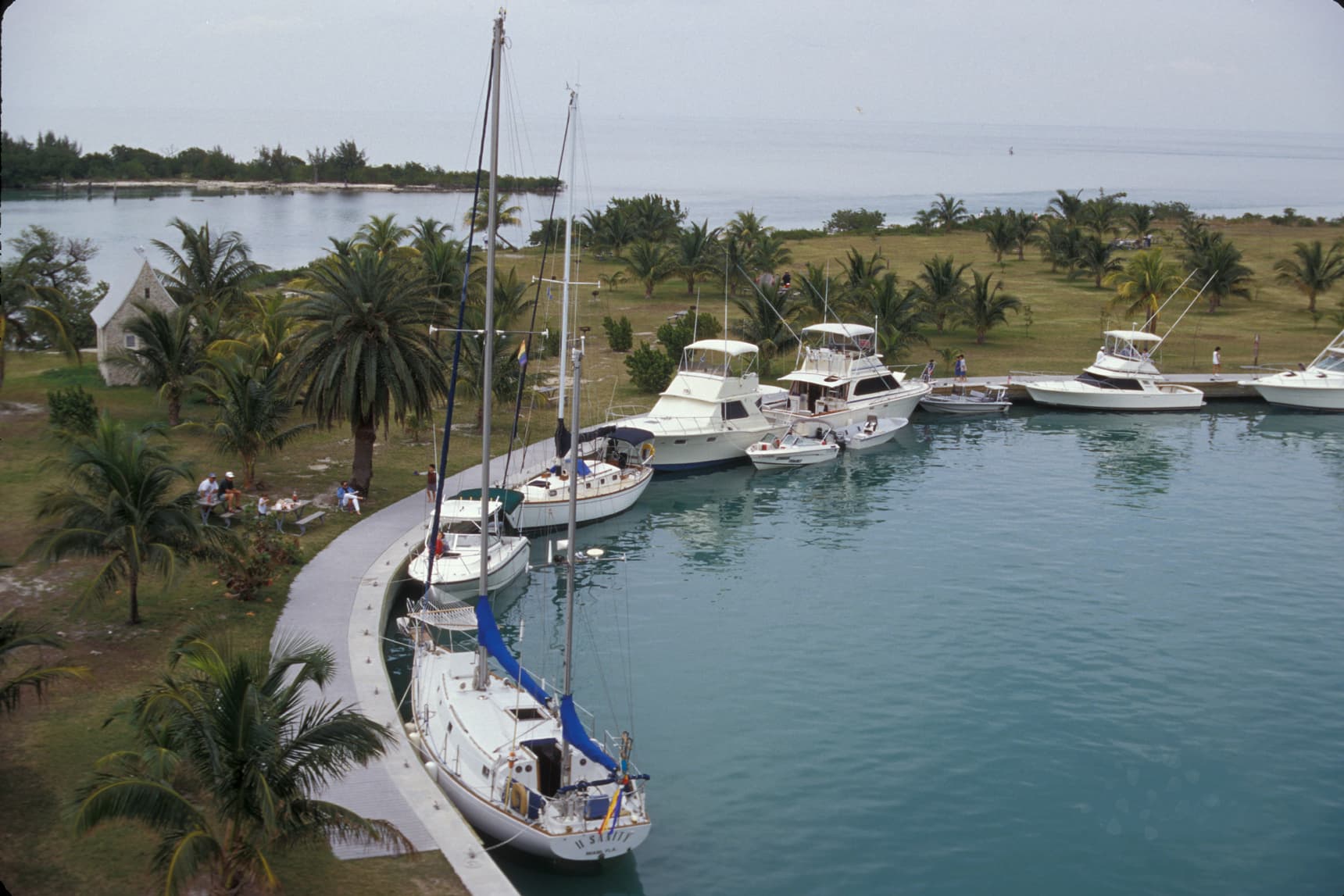
A national park that is almost entirely water
Most national parks are places you drive into. Biscayne is a place you sail into. The park protects Biscayne Bay and the northernmost stretch of the Florida Keys, just south of downtown Miami — and about 95 percent of it is water. That single fact shapes everything about a visit. There are no scenic park roads winding through it, no overlooks you pull off the highway to admire. Instead there is a bay of aquamarine shallows, a living coral reef offshore, a chain of low, green islands, and a mangrove-fringed mainland shore. To see Biscayne, you get on the water: by tour boat, by kayak, by snorkel or scuba, or in your own boat if you have one.
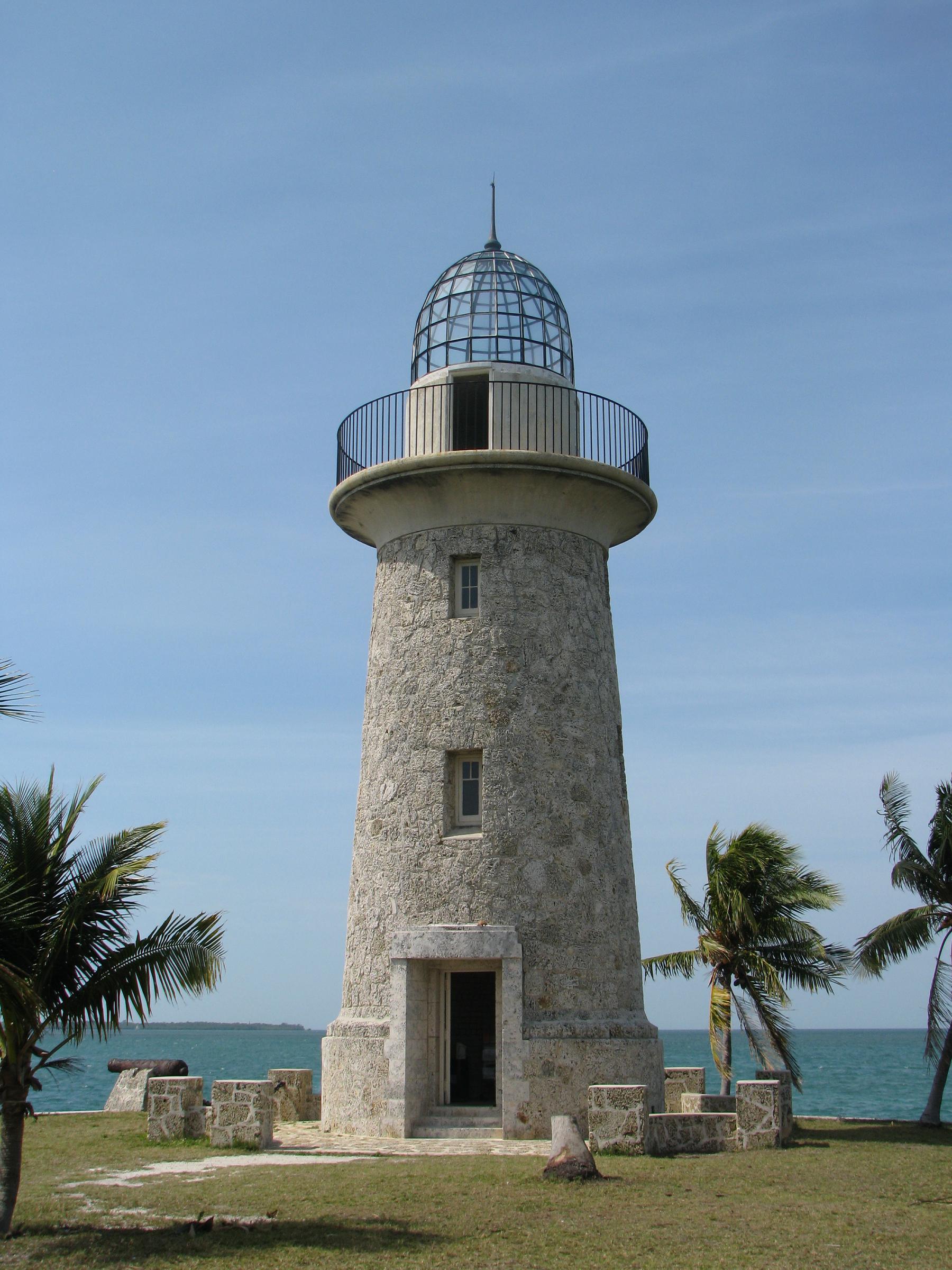
That is also what makes Biscayne one of the most unusual parks in the national park system, and one of the easiest for a Miami visitor to misunderstand. From the mainland, the park can look like nothing at all — just the bay, stretching east toward the horizon. But the bay is the park. Its shallow waters hold seagrass meadows that feed manatees and sea turtles. Its offshore reef — part of the Florida Reef Tract, the only living coral barrier reef in the continental United States — shelters hundreds of species of fish. Its islands, the northernmost of the Florida Keys, hold hardwood hammocks, beaches, campgrounds, and a lighthouse that looks like it belongs in a storybook. Biscayne rewards the visitor who treats the water as the destination, not as the obstacle between destinations.
The park sits at the edge of two worlds. To the west is the Miami metropolitan area, one of the largest cities in the country, and on a clear day the downtown skyline is visible from the park's islands. To the east is the open Atlantic, the Gulf Stream, and the reef. Biscayne is where the city ends and the sea begins — a place where you can watch the sun rise over the ocean from a quiet island beach and still be back in Miami for dinner. For a first-time visitor to South Florida, it is the single best introduction to what this coastline actually is: not just beaches and hotels, but a shallow tropical bay, a coral ecosystem, and a chain of islands that have been crossed by sailors, smugglers, farmers, and fishermen for centuries.
From national monument to national park
Biscayne's protected status began with a fight over its future. In the 1960s, developers proposed building a city — Islandia — on the park's northern keys, linked by a causeway to the mainland, with homes and resorts across Elliott Key and its neighbors. Local conservationists, fishermen, and residents pushed back, arguing that the bay and its islands were worth more intact than developed. President Lyndon B. Johnson established Biscayne National Monument in 1968, protecting the bay and the keys from development. In 1980, Congress redesignated it as Biscayne National Park, expanding its boundaries and giving it the full status it holds today.
That history still matters because it explains what the park is not. Unlike the Everglades, which protects a vast freshwater wetland, Biscayne protects a marine landscape — a bay, a reef, and islands. And unlike the developed Florida Keys to the south, where the Overseas Highway runs island to island, Biscayne's keys have no road connection to the mainland at all. The only way to reach them is by boat. That absence of roads is the direct legacy of the 1968 monument designation: the causeway was never built, the city of Islandia never rose, and Elliott Key remains the largest undeveloped island in the park rather than a suburb.
The park is named for Biscayne Bay, and the bay's name reaches back further still — to the Basque sailors, the Biscayans, who fished and traded along this coast in the age of sail. Long before the monument, these waters were worked by Tequesta people, then by Bahamian fishermen and wreckers, then by farmers who grew pineapples and limes on Elliott Key in the early twentieth century. The park's story is not only a natural one. It is a story of people who lived off this bay, and of a conservation decision that kept the bay's islands wild when they could easily have become something else entirely.
Convoy Point: where the park begins
Every Biscayne visit starts, in practice, at the Dante Fascell Visitor Center at Convoy Point in Homestead, the park's mainland gateway. This is the park's only mainland access point, and it is where the land-based part of the park lives: the visitor center itself, a jetty, a boardwalk along the mangrove shoreline, picnic areas, and a small marina. If you are not arriving by your own boat, this is where you orient yourself, talk to rangers, and join a guided boat tour. It is also, frankly, a pleasant place in its own right — a quiet waterfront park at the end of a road through Homestead's farmland, far from the Miami crowds.
The visitor center is named for Dante Fascell, the longtime Florida congressman who championed the park's creation and expansion. Inside, exhibits explain the park's four ecosystems — the mangrove shoreline, the bay itself, the keys, and the offshore reef — and rangers can advise on conditions, tours, and what is realistic for the day you are there. The boardwalk outside runs through the mangroves at the water's edge, and even a short walk here gives you the park's essential lesson: this is a shoreline built by trees standing in salt water, a nursery for the fish and crabs that fill the bay.
Convoy Point is also the honest starting point for planning. Because the park is mostly water, a visit here is not a drive-through experience. Ranger-led and concession boat tours leave from the park or nearby marinas, and visitors with their own boats can launch from the marina area. If you arrive expecting to drive to the reef or the islands, you will be disappointed; if you arrive expecting to plan a boat day, you will find the visitor center staff ready to help you do exactly that. Check the official National Park Service source before your visit for current tour schedules and visitor center hours, as these change seasonally.
The keys: Boca Chita, Elliott, and Adams
The islands are the park's most distinctive land, and they are worth understanding one by one. The northernmost keys form a chain running south from the bay's mouth, and three of them anchor most visits.
Boca Chita Key is the park's postcard. It is a small island with a harbor, a campground, and a lighthouse — a 65-foot ornamental tower built in the 1930s by Mark Honeywell, a former owner of the island, that was never an official aid to navigation. The lighthouse is not open to climb on a regular schedule, but it is the park's most photographed structure, a white tower with a black top standing over a turquoise harbor, with the Miami skyline sometimes visible in the distance. Boca Chita is compact, walkable, and a popular overnight stop for boaters, with a small beach, picnic areas, and campsites.
Elliott Key is the park's big island — the largest of the northern Florida Keys, a long, narrow strip of hardwood hammock and mangrove that stretches for miles along the park's eastern edge. It has a harbor, a campground, miles of trails, and a swimming area, and it is the island that most rewards a full day: hike the trails through the hammock, swim, and watch for the island's wildlife, from warblers to the occasional crocodile in the surrounding waters. Elliott Key is also where the Islandia story is most tangible — the island that was nearly developed, now kept wild, its old farmland reclaimed by forest.
Adams Key is smaller and quieter, a day-use island with picnic areas and trails through its hammock, popular with boaters looking for a less crowded stop. Together, the three keys give a sense of the park's range: a postcard harbor, a wild long island, and a quiet picnic stop, all reachable only by water, all part of the same protected chain.
The reef and the Maritime Heritage Trail
Offshore, beyond the keys, lies the reason many visitors come: the coral reef. Biscayne's reef is part of the Florida Reef Tract, and its waters hold elkhorn and brain corals, sea fans, and the reef fish — parrotfish, angelfish, grunts, and snappers — that make South Florida snorkeling famous. Snorkeling and diving trips from the park and nearby marinas visit the reef and the shallower patch reefs of the bay, where the water is warm and the visibility, on a good day, is the clear blue-green of a postcard. The reef is a living structure, fragile and slow-growing, and the park asks visitors to treat it that way: look, float, and do not touch or stand on the coral.
The reef also holds the park's history in a different form. Biscayne's Maritime Heritage Trail links a series of shipwrecks on the reef and in the bay, from nineteenth-century sailing ships to twentieth-century steamships and freighters, each marked and interpretable for divers and snorkelers. These wrecks are not curiosities; they are the record of a coastline that was, for centuries, one of the most dangerous passages in American waters — the Florida Reef claimed hundreds of ships before modern navigation. Diving the trail is, in a real sense, diving through the park's history: the same reef that wrecked ships now shelters the fish that draw visitors, and the wrecks themselves have become artificial reefs, colonized by coral and sponge.
Not every visitor will dive, and the park does not require it. Glass-bottom boat tours offer a view of the reef without getting wet, and snorkeling the bay's shallower waters is accessible to beginners. But whatever the depth, the rule is the same: the reef is the park's most precious and most vulnerable feature, and the best way to enjoy it is to leave it exactly as you found it.
The mangrove shoreline and the bay
It would be a mistake to treat the reef and the keys as the whole park and skip the bay itself. Biscayne Bay is a shallow, subtropical lagoon, and its ecosystems — the mangrove shoreline, the seagrass beds, the mud flats — are the engine that feeds everything else. The mangroves along the mainland shore and the islands' western edges are nurseries: young fish, shrimp, and crabs shelter among their roots before moving out to the reef. The seagrass meadows feed manatees and green sea turtles. The bay's shallows are where wading birds — egrets, herons, ibis — feed at low tide, and where the park's American crocodiles, a threatened species that has recovered here, are sometimes seen basking or swimming.
Kayaking is the best way to experience this side of the park. Paddling the mangrove shoreline from Convoy Point, or the bay's calm western waters, puts you at the level of the ecosystem — close enough to watch herons stalk the shallows, to see rays glide under the kayak, and to understand why the bay matters beyond its beauty. The water is shallow and generally calm, which makes it approachable for paddlers of moderate experience, though wind and weather on an open bay deserve respect: check conditions before launching, carry water and sun protection, and remember that you are in a subtropical environment where weather can change quickly.
The bay is also the park's most threatened ecosystem. Runoff, seagrass die-offs, and warming waters have stressed Biscayne Bay in recent years, and the park's managers work with state and local partners on restoration. A visit to Biscayne is, in that sense, a visit to a place whose future is not guaranteed — a living bay at the edge of a major city, protected on paper since 1968 and 1980, but dependent on the health of the waters that flow into it. That fragility is part of why the park exists, and part of what makes seeing it well worth the effort.
Why Biscayne belongs on a Miami itinerary
Miami visitors are spoiled for choice — beaches, museums, Little Havana, the Art Deco District — and a national park that requires a boat can seem like a detour. It is the opposite. Biscayne is the one Miami experience that cannot be replicated anywhere else in the city: a national park, on the water, protecting a coral reef and a chain of wild islands within sight of a major American city. There is no other place in the continental United States where you can snorkel a living barrier reef, camp on an undeveloped key, and be back in a city of millions the same evening.
The park is also, by national-park standards, uncrowded. Its watery geography spreads visitors out — across the bay, across the islands, across the reef — and even on a busy day, Boca Chita's harbor or Elliott Key's trails feel quieter than any Miami beach. Come for a day, or come for a night under the stars on a key campground, where the sky is darker than anywhere in the city and the sound of the bay replaces the sound of traffic. Either way, come by boat, come prepared for sun and salt water, and come with the expectation that the park will not hand itself to you from a car window. Biscayne rewards the visitor who meets it on its own terms — on the water, at the pace of the bay — and it repays that effort with one of the most distinctive landscapes in the entire national park system.
Key Facts
- Biscayne National Park protects Biscayne Bay and the northernmost islands of the Florida Keys, just south of Miami, Florida. About 95 percent of the park is water.
- The area was established as Biscayne National Monument in 1968 and redesignated as Biscayne National Park in 1980.
- The park's name comes from Biscayne Bay, named for the Basque (Biscayan) sailors who worked these waters in the age of sail.
- The park's mainland gateway is the Dante Fascell Visitor Center at Convoy Point in Homestead, Florida, named for the congressman who championed the park's creation and expansion.
- The park encompasses four ecosystems: the mangrove shoreline, Biscayne Bay, the Florida Keys, and the offshore coral reef, part of the Florida Reef Tract — the only living coral barrier reef in the continental United States.
- Boca Chita Key, Elliott Key, and Adams Key are among the park's principal islands. Elliott Key is the largest of the northern Florida Keys. Boca Chita Key's 65-foot ornamental lighthouse was built in the 1930s by former island owner Mark Honeywell and was never an official aid to navigation.
- In the 1960s, developers proposed a city called Islandia on the northern keys, linked by a causeway to the mainland. The monument designation in 1968 stopped that development, and the keys remain accessible only by boat.
- The Maritime Heritage Trail links shipwrecks on the reef and in the bay, from nineteenth-century sailing vessels to twentieth-century steamships and freighters, now serving as artificial reefs.
- The park's waters support manatees, sea turtles, American crocodiles, and hundreds of species of reef fish, along with wading birds including egrets, herons, and ibis.
- The islands have no road connection to the mainland. They are reached only by boat — by private vessel, by concession or ranger-led tour, or by kayak and canoe where conditions allow.
Visitor Details
Address: Dante Fascell Visitor Center, 9700 SW 328th Street, Homestead, FL 33033 (Convoy Point — the park's mainland gateway)
Access: The park's islands and reef are accessible only by boat. Ranger-led and concession boat tours depart from the park area and nearby marinas; visitors with private boats can use the marina at Convoy Point. There are no roads to the islands.
Hours/Admission: Check the official National Park Service source (nps.gov/bisc) before your visit for current visitor center hours, tour schedules, and any entrance or tour fees, as these change seasonally and are not stated here as fixed facts. Campgrounds on Boca Chita Key and Elliott Key are boat-in only and operate on a first-come, first-served basis unless the official source states otherwise.
Best timing: The dry, cooler months are generally the most comfortable for boating, snorkeling, and camping; summer brings heat, humidity, and afternoon thunderstorms. Check marine weather and bay conditions before launching a kayak or private boat. Bring sun protection, water, and reef-safe habits: do not touch or stand on coral, and leave wrecks and wildlife undisturbed.
Location Photography