
A village inside a city
Walk across the Rose Kennedy Greenway from downtown Boston, past the spot where an elevated highway once walled the neighborhood off, and the city changes in about ten steps. The streets narrow. The buildings drop to three and four stories of brick. Signs switch to Italian names, laundry hangs over alleyways, and the smell of garlic, espresso, and fresh bread takes over. This is the North End, Boston's oldest residential community — a neighborhood of about a third of a square mile that has been continuously inhabited since the 1630s, and that still holds, by one common count, nearly a hundred restaurants, cafes, bakeries, and food shops in a patch of ground you can cross on foot in fifteen minutes.
That smallness is the point. The North End was laid out before Boston had room to sprawl, on a thumb of land jutting toward the harbor, and it never got the wide avenues and big blocks that came later. Its streets still follow the crooked property lines and footpaths of the seventeenth century. Hanover Street runs like a spine through it, Salem Street parallels it a block away, and between them a tangle of short cross streets — Prince, Tileston, Fleet, Hull, Charter — connects pocket squares, tiny parks, and churchyards. You do not visit the North End the way you visit a museum, one building at a time. You wander it, and the wandering is the experience: every turn puts a different century in front of you.
The neighborhood rewards that kind of walking because it has never been a single thing. It began as a Puritan settlement, became a crowded immigrant quarter for the Irish, then for Eastern European Jews, then — decisively — for Italians from the south of Italy, and it is still, beneath the restaurants and the tour groups, a residential neighborhood where people live above the shops and argue about parking and feast-day processions. The famous sites are here, and this article touches them, but it is deliberately not a guide to any one of them: the Paul Revere House and the Old North Church each have their own stories, told elsewhere. This is the story of the streets between them, and of how a seventeenth-century neighborhood became Boston's Little Italy without ever stopping being itself.
The oldest streets in Boston
The North End's claim to age is not a slogan. It is the city's oldest residential community, inhabited continuously since Boston was settled in the 1630s, and its street plan still shows it. The neighborhood grew up around North Square, the small open space at the foot of the hill where the town's early merchants built, and around the wharves that once lined its shores. In the colonial era this was a prosperous place: shipwrights, merchants, and ministers lived here, and the houses they built — timber-framed, narrow, and close to the street — set the pattern the neighborhood still follows.
Two of those early buildings anchor the story, and they are worth naming even though they are not this article's subject. The Paul Revere House, on North Square, was built around 1680 and is the oldest remaining structure in downtown Boston; Revere owned it from 1770 to 1800 and left from here on his midnight ride. The Old North Church, a few minutes away on Salem Street, was built in 1723 and is Boston's oldest standing church building; its steeple carried the two lanterns on the night of April 18, 1775, that signaled the British were crossing the Charles River by boat. The Freedom Trail runs straight through the North End between them, and it is the best spine for a first walk: follow the red brick line from the Greenway up Hanover Street, detour to North Square, climb to Copp's Hill, and you will have seen the neighborhood's colonial layer without ever leaving its living streets.
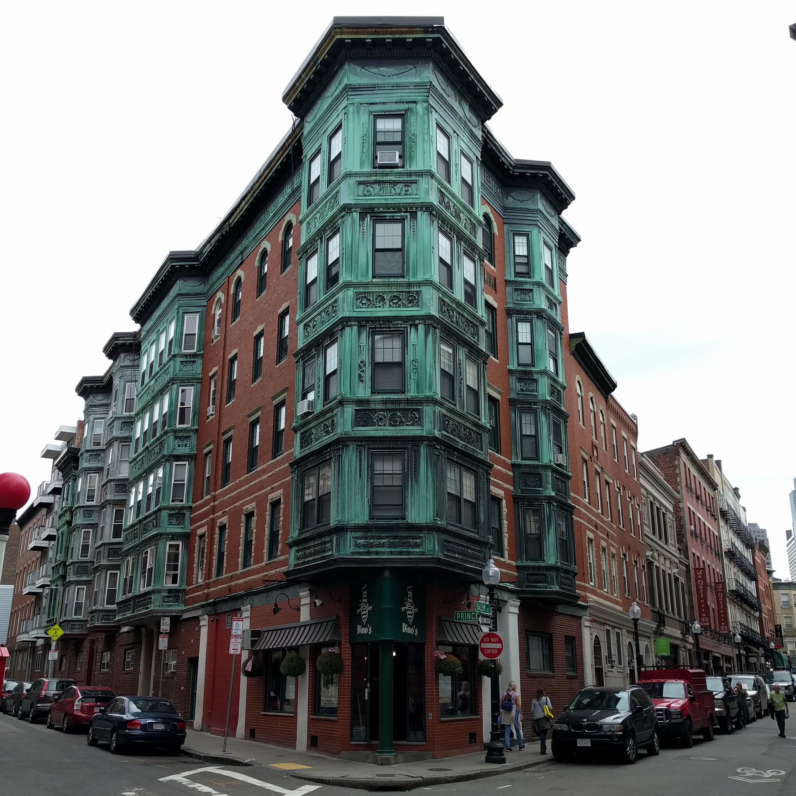
But the colonial North End is only the bottom layer. By the middle of the nineteenth century the merchants had moved to newer neighborhoods, and the North End became a landing place for immigrants — first Irish families fleeing famine, then Eastern European Jews, who built synagogues on streets like Baldwin Place and Salem Street. The tenements went up fast and crowded: by the early twentieth century the North End was one of the most densely populated neighborhoods in America, its narrow streets packed with families, pushcarts, and small workshops. The brick buildings you see today, four and five stories tall with shops at street level, are largely the product of that immigrant century, not the colonial one — and that is why the neighborhood feels both old and lived-in at once.
How it became Little Italy
The transformation that defines the modern North End began in the late nineteenth century and accelerated in the first decades of the twentieth, when large numbers of immigrants from southern Italy — from Sicily, Campania, Calabria, and Abruzzo — settled here. They came for work on the docks, in construction, and in the food trades, and they remade the neighborhood in their own image: Italian groceries, barber shops, social clubs, and mutual-aid societies filled the storefronts; Italian became the language of the street; and the Catholic parishes, above all St. Leonard's on Prince Street, founded by Italian immigrants, became the neighborhood's civic spine.
What is remarkable is how durable that identity proved. Other immigrant neighborhoods in American cities faded as their residents moved to the suburbs, but the North End's Italian character held — partly because the neighborhood is so small and so bounded by water and highway that it never sprawled, and partly because the institutions stayed: the same family bakeries, the same feast societies, the same parish churches, passed down through generations. Today the North End is still known, in Boston and well beyond it, as the city's Little Italy, and the name is used by locals as well as guidebooks — though old-timers will tell you that to them it is simply the North End, and always has been.
That continuity is visible in the food, which is the neighborhood's real economy and its real culture. Hanover Street is the main restaurant row, lined with red-sauce restaurants, oyster bars, and cafes, many of them in spaces that have served food for decades. Salem Street, a block over, is quieter and more residential, with bakeries and specialty shops. The pastry rivalry is the stuff of local legend: Mike's Pastry on Hanover Street and Modern Pastry on the same street draw lines out the door, and Bova's Bakery on Salem Street — founded by Italian immigrant Antonio Bova in 1926, according to its history — has served the neighborhood for nearly a century and keeps long hours that have made it a late-night institution. No fixed prices are stated here, because menus change; the honest advice is to expect a wait at the famous counters, to carry cash or a card as the shop prefers, and to treat the pastry crawl — one cannoli here, one there, a lobster tail pastry somewhere else — as a legitimate way to spend an afternoon.
Hanover Street, Salem Street, and the squares between
If you have only an hour, spend it on two streets. Hanover Street is the North End's high street and its stage: it runs from the Greenway at its downtown end all the way to Commercial Street at the waterfront, and it carries the densest concentration of restaurants, cafes, and shops in the neighborhood. The stretch between the Greenway and Union Street is closed to traffic on some market days for the Haymarket open-air market, a tradition that predates the neighborhood's Italian era and still draws produce vendors and bargain hunters. Walking Hanover Street end to end is a survey of the neighborhood in miniature: the restaurant facades and hanging signs, the narrow side streets peeling off toward the water, the churches and the Prado, and finally the waterfront itself, where the neighborhood meets the harbor.
Salem Street is Hanover's quieter sibling, and in some ways the more revealing walk. It runs roughly parallel, a block to the north, and it is more residential: fewer tour groups, more laundry lines, more of the daily life of the people who actually live here. It is also the street of the Old North Church, whose white steeple is visible from much of the neighborhood and serves as a landmark for navigation — if you can see the steeple, you know which way is north. Bova's Bakery sits at the corner of Salem and Prince Streets, and the surrounding blocks hold some of the neighborhood's best-preserved tenement architecture, the brick facades and fire escapes that are the North End's real vernacular.
Between the two streets, and slightly to the north, lie the neighborhood's open spaces — and in a place this dense, every open space matters. North Square, at the foot of the hill, is the neighborhood's oldest public space, a small paved square flanked by the Paul Revere House and the Pierce-Hichborn House, and a natural gathering point on the Freedom Trail. The Prado, also called the Paul Revere Mall, is a tree-lined brick mall between Hanover Street and Salem Street, opened in 1933 after a narrow tenement street was cleared to let light and air into the crowded district; its centerpiece is Cyrus Dallin's equestrian statue of Paul Revere, unveiled in 1940, with the Old North Church steeple rising behind it. And at the neighborhood's northern edge, Copp's Hill Terrace — a granite staircase and plaza designed in the 1890s by landscape architect Charles Eliot — climbs the hill beside Copp's Hill Burying Ground and opens onto a view over Commercial Street and the harbor. These are not grand parks. They are the breathing spaces of a crowded neighborhood, and on a summer evening they fill with residents, children, and visitors in exactly the proportions you would hope.
Copp's Hill: the quiet end of the walk
Climb to the top of the North End and the noise drops away. Copp's Hill, the neighborhood's highest ground and its third-highest hill in the city after Beacon Hill and Fort Hill, holds the Copp's Hill Burying Ground, Boston's second-oldest burial ground, dating to 1659. It is a Freedom Trail stop in its own right, and it is worth the climb for two reasons: the history underfoot and the view from the top.
The burying ground holds the graves of merchants, ministers, and artisans from the colonial and early republican city, along with free and enslaved Black Bostonians who lived on the hill — including Prince Hall, the abolitionist and founder of Black Freemasonry in America, whose grave is here. The gravestones, many of them carved with winged skulls and cherubs by early Boston stonecutters, are some of the finest examples of colonial funerary art in New England. During the Revolution the hill was a military position: British guns on Copp's Hill fired across the harbor at Charlestown during the Battle of Bunker Hill in June 1775, and the neighborhood below watched its neighbor town burn.
From the terrace beside the burying ground, the view opens north and east: over the rooftops of the North End, across Commercial Street, to the harbor and the Zakim Bridge. It is the best place in the neighborhood to understand its geography — a peninsula neighborhood, bounded by water on two sides, its streets running down to wharves that once made it a working port. The Skinny House, across Hull Street from the burying ground, is the neighborhood's beloved oddity: an extremely narrow four-story house, built after the Civil War as a spite house on a sliver of inherited land, and reported by the Boston Globe as the narrowest house in Boston. It is a private home, not a museum, so admire it from the street and move on — it is a perfect North End story precisely because it is so small, so stubborn, and so much about family and property and pride.
Feasts, festivals, and the summer streets
If the North End has a season, it is summer, and if it has a signature event, it is the feast. From roughly June through September, the neighborhood's religious societies stage street festivals — the feasts — honoring patron saints, above all St. Anthony of Padua in August and the Madonna del Soccorso, the Fisherman's Feast, in the same month. The pattern is the same every year and it is gloriously chaotic: a statue of the saint is carried through the streets in procession, preceded by a marching band and followed by crowds; Hanover Street and the side streets fill with food stalls, games, and music; and the neighborhood, already crowded, becomes a street party that lasts for days.
The feasts are not a tourist invention. They were brought from southern Italy by the immigrants who settled here, and they are still organized by the neighborhood's feast societies, many of them based in the same parishes that anchored the immigrant community a century ago. Visitors are welcome — the feasts are public, outdoor, and free to wander — but it is worth remembering that they are religious processions before they are street fairs, and that the families carrying the statue are carrying their own history. Go for the food and the music, stay for the procession, and give the statue room to pass. No fixed dates are stated here, because feast weekends shift year to year; check the neighborhood's feast calendar before planning a trip around one.
Beyond the feasts, the North End's calendar is the calendar of a working neighborhood: farmers' market stalls at Haymarket, outdoor dining spilling onto Hanover Street in warm weather, Christmas lights and shop windows in December, and the steady rhythm of the pastry shops and cafes that never really close. That everyday rhythm is what separates the North End from a theme park. It is a place where people buy bread, argue with the butcher, send their children to the neighborhood school, and worship at the parish church — and the fact that visitors can walk through all of it, on streets that have barely changed their shape in three centuries, is the neighborhood's real attraction.
The highway, the Greenway, and the neighborhood's second chance
No honest account of the modern North End can skip the highway. In the 1950s the Central Artery — an elevated expressway carrying Interstate 93 — was built along the neighborhood's downtown edge, and it walled the North End off from the rest of Boston for half a century. The roar of traffic overhead, the shadow beneath the roadway, and the severed street connections isolated a neighborhood that had always lived by its connections to the waterfront and to downtown. The North End survived, as it had survived everything else, but it survived behind a wall.
The Big Dig changed that. In the 2000s the elevated highway was taken down and the traffic buried in a tunnel, and the land where the roadway had stood became the Rose Kennedy Greenway, a ribbon of parks, gardens, and public art that now links the North End to downtown, to the waterfront, and to the rest of the city. Cross the Greenway from Faneuil Hall or Haymarket and you step from the modern city into the old neighborhood in a single crossing — and that crossing, from green lawns and glass towers to brick tenements and Italian signs, is one of the great small transitions in Boston. The Greenway also gave the neighborhood something it had always lacked: a front door. The North End's parks at its edge, including North End Park with its bocce courts and harbor views, are where the neighborhood meets the city, and on a summer day they are full of both.
That reconnection is the reason the North End feels so alive right now. The neighborhood did not have to be invented for tourists — it was already here, already dense, already Italian, already old. What the Greenway did was remove the barrier that had hidden it, and let the city walk in. The result is a neighborhood that is both more visited and more itself than it has been in decades: the restaurants are busier, the feasts are bigger, the streets are fuller, and the residents are still there, still living above the shops, still arguing about the same things. That tension — between a living neighborhood and a famous one — is the North End's present condition, and it is worth noticing as you walk it.
How to walk it
The best way to see the North End is on foot, and the best route is simple. Start at Haymarket station or at the Greenway, cross into the neighborhood, and walk Hanover Street from its downtown end toward the waterfront, detouring to North Square and the Prado as you go. Turn up Salem Street for the quieter, more residential side, and climb to Copp's Hill for the burying ground, the Skinny House, and the harbor view. Then come back down to Hanover Street for dinner and dessert — and if you have to choose, choose one pastry shop and commit to it, because the lines are part of the experience and the debate about which is best is older than most of the people standing in them.
Allow at least half a day, and a full day if you want to visit the Paul Revere House and the Old North Church properly, since each has its own hours and admission and deserves unhurried time. Wear comfortable shoes: the streets are narrow, the sidewalks are brick and sometimes uneven, and the hills — especially the climb to Copp's Hill — are real. And leave room in the plan for getting lost. The North End is small enough that you cannot stay lost for long, and its best moments — a courtyard glimpsed through an archway, a bakery window on a side street, a view of the harbor between two buildings — are the ones you find when you are not following a route at all.
The North End endures because it has always been a place where people live, not just a place people visit. Its streets have held Puritan merchants, Irish laborers, Jewish shopkeepers, and Italian families, and they now hold their descendants, their neighbors, and a stream of visitors who come for dinner and stay for the history. Walk it slowly, eat well, look up at the steeples and the fire escapes, and you will understand why Boston's oldest neighborhood is still its most beloved — not because it is preserved in amber, but because it never stopped being alive.
Key Facts
- Boston's oldest residential community, continuously inhabited since the 1630s, about 0.36 square miles, with nearly one hundred restaurants, cafes, bakeries, and food shops.
- Hanover Street runs from the Rose Kennedy Greenway to Commercial Street; Salem Street parallels it.
- North Square is the neighborhood's oldest public space; the Paul Revere House there was built about 1680, is the oldest remaining structure in downtown Boston, and Revere owned it from 1770 to 1800.
- The Old North Church, built in 1723, is Boston's oldest standing church building; its steeple carried two lanterns on April 18, 1775. The Freedom Trail runs through the North End.
- The Prado (Paul Revere Mall) opened in 1933; Cyrus Dallin's equestrian statue of Paul Revere was unveiled in 1940.
- Copp's Hill Burying Ground dates to 1659, is Boston's second-oldest burial ground, and holds Prince Hall's grave; British guns there fired on Charlestown during the Battle of Bunker Hill in June 1775.
- Copp's Hill Terrace was designed in the 1890s by landscape architect Charles Eliot and listed on the National Register in 1990.
- The Skinny House on Hull Street is the narrowest house in Boston, according to the Boston Globe; it is a private home, not a museum.
- St. Stephen's Church on Hanover Street was built in 1804 to Charles Bulfinch's design, the last remaining Bulfinch church in Boston; Rose Fitzgerald Kennedy was baptized there in 1890.
- Italian immigration in the late 19th and early 20th centuries made the North End Boston's Little Italy; St. Leonard's on Prince Street was founded by Italian immigrants.
- Bova's Bakery was founded in 1926 by Antonio Bova; Mike's Pastry and Modern Pastry on Hanover Street are the rival pastry shops.
- Summer feasts include St. Anthony and the Fisherman's Feast (Madonna del Soccorso) in August, organized by the neighborhood's feast societies.
- The Central Artery elevated highway, built in the 1950s, walled the neighborhood off; the Big Dig buried it and the Rose Kennedy Greenway replaced it in the 2000s.
- The Great Molasses Flood on January 15, 1919, when a tank burst on Commercial Street, killed 21 people.
Gallery