The Idea: One Walk, Sixteen Stories
Before 1951, Boston's Revolutionary landmarks were scattered across the city, open on different days, at different hours, with nothing to connect them. A local journalist named William Schofield had an idea: link them together with a single walking route, so a visitor could follow the whole story of the Revolution on foot. He published the concept in his "Have You Heard" column in the Evening Traveler on March 8, 1951, and by the end of the month, Mayor John B. Hynes had agreed to make it official. Boston installed thirty directional signs, and by 1953, more than 40,000 people a year were walking the new Freedom Trail.
The famous red line came a few years later. In 1958, the route was marked with a continuous red-brick and red-painted stripe in the pavement — the line every walker follows today. The Freedom Trail Foundation was established in 1964 to promote and preserve the route, the Bunker Hill Monument and the USS Constitution were added to the trail in 1972, and in 2000 the White House Millennium Council named the Freedom Trail one of sixteen National Millennium Trails. Today between three and four million people walk some part of it every year, making it one of the most-visited historical attractions in the country.
Boston Common: America's Oldest Public Park
The trail begins at Boston Common, the oldest public park in the United States. The land was first settled by William Blackstone, Boston's first European settler; the Puritans purchased it from him in 1634 and designated it as common grazing land for the town's cattle. For over a century it was also a site of public punishment and executions, and in 1775, more than a thousand British soldiers camped and drilled on the Common as the Revolution approached.
Starting here is a deliberate choice: the Common is where Boston has gathered for nearly four hundred years — for war, for protest, and for celebration. The trail's Visitor Information Center sits at 139 Tremont Street, at the Common's Park Street corner, and the red line starts just steps away.
The State House and the Corner That Lit the Revolution
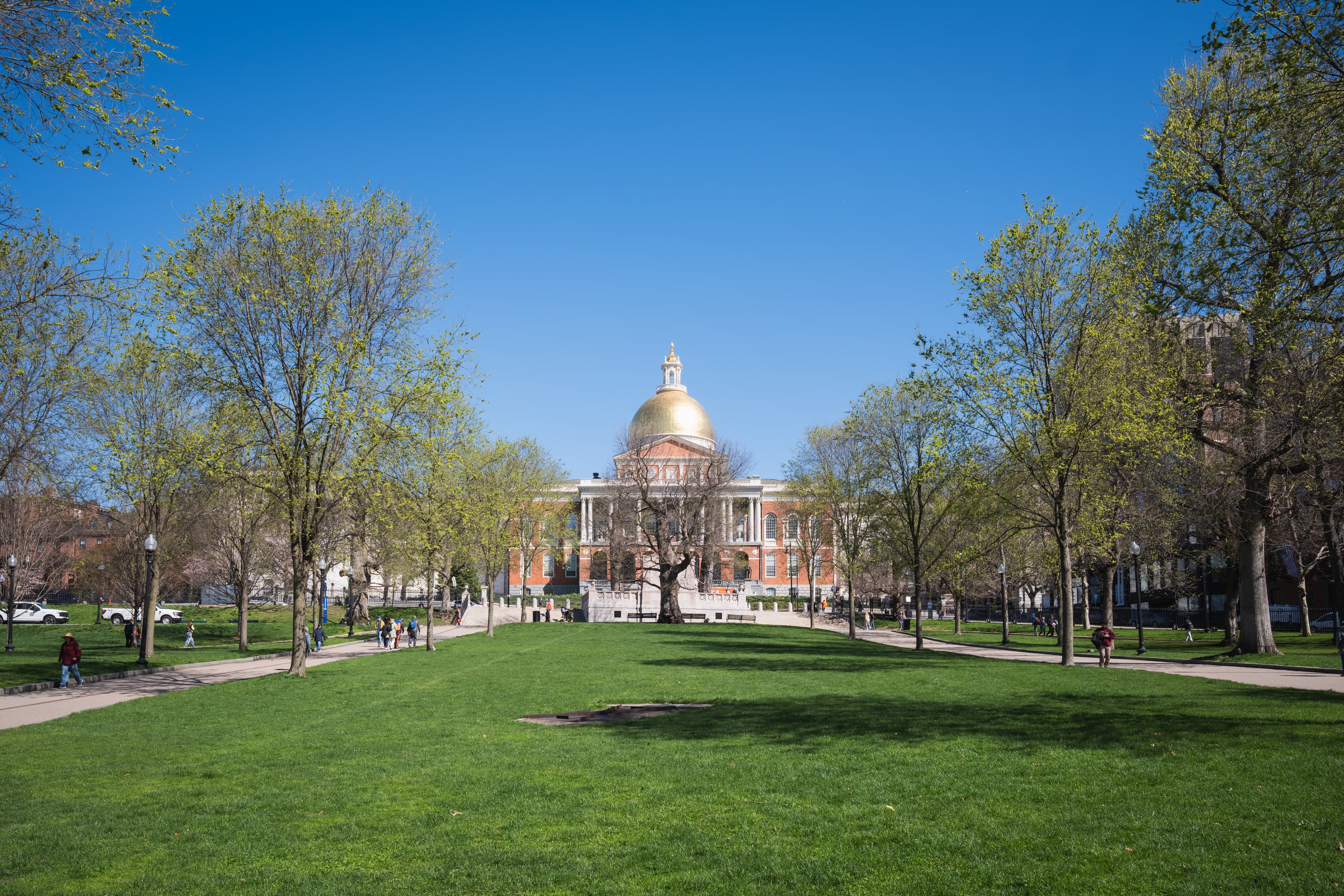
From the Common, the line climbs to the Massachusetts State House, its golden dome the city's most recognizable silhouette. Completed in 1798 and designed by Charles Bulfinch, it is the seat of Massachusetts state government. The dome was originally made of wood shingles, then sheathed in copper rolled by Paul Revere's own foundry, and gilded with 23-karat gold leaf in 1874. The building sits on land that was once John Hancock's cow pasture, on Beacon Hill overlooking the Common.
One block down Tremont Street stands Park Street Church, built in 1809. Its corner was nicknamed "Brimstone Corner" for the fiery abolitionist and patriotic speeches delivered there. On July 4, 1831, the congregation sang "America (My Country, 'Tis of Thee)" for the first time in public, and two years earlier, William Lloyd Garrison delivered his first public abolitionist speech from its pulpit. The church remains an active congregation, and its towering steeple was long a mariner's landmark for ships entering Boston Harbor.
Granary and King's Chapel: Boston's Revolutionary Dead
The Granary Burying Ground, founded in 1660, is the trail's most concentrated patch of Revolutionary history per square foot. Samuel Adams lies here, and Paul Revere, and John Hancock — along with five victims of the Boston Massacre, including Crispus Attucks, and Peter Faneuil, the merchant who gave the city Faneuil Hall. The burying ground takes its name from the grain storage building that once stood nearby.
Next door, King's Chapel tells the other side of the story. Founded in 1686, it was the first Anglican church in New England — built by royal decree over the objections of Boston's Puritans. The current granite building dates to 1749–1754, and the adjacent burying ground, dating to 1630, is the city's oldest. Inside the chapel, the pulpit is among the oldest in continuous use in the country. Together, the two sites hold the graves and the ghosts of both the Revolution's heroes and the colonial establishment they overthrew.
Where the Revolution Was Spoken: Old South, Old State House, Faneuil Hall
The Old South Meeting House, built in 1729, was the largest building in colonial Boston — and the room where the Revolution found its voice. On the evening of December 16, 1773, more than 5,000 people crowded into the meeting house and the streets outside, debated the tea tax to a standstill, and then marched to Griffin's Wharf to destroy the tea in Boston Harbor. The meeting house was nearly destroyed by the British during the occupation; it survives today as a museum and a National Historic Landmark.
A few blocks away, the Old State House, built in 1713, is the oldest surviving public building in Boston. It was the seat of British colonial government, and the Boston Massacre of March 5, 1770, happened on the cobblestones directly in front of it, when British soldiers fired into a crowd of colonists and killed five. Six years later, on July 18, 1776, the Declaration of Independence was read to Bostonians for the first time from the building's balcony. The gold lion and unicorn on the roof — symbols of the British Crown — were taken down during the Revolution and later restored.
Then comes Faneuil Hall, the "Cradle of Liberty." Merchant Peter Faneuil donated it to the town in 1742 as a marketplace with a meeting hall above; Charles Bulfinch expanded it in 1806 to the building we see today. From its stage, Samuel Adams and others rallied the cause of independence; later, abolitionists, suffragists, and labor leaders took the same podium. The market stalls of Quincy Market still operate at its back, but the hall above remains a working forum for public debate, just as it was in the 1760s.
The North End: Revere's Midnight Ride
Crossing into the North End, the trail reaches the Paul Revere House, built around 1680 and the oldest building in downtown Boston. Revere, the silversmith and engraver, bought the house in 1770 and lived there with his family for thirty years. It was from this house that he set out on the evening of April 18, 1775, on the midnight ride to Lexington and Concord. The small colonial rooms are furnished with period pieces and Revere family memorabilia.
One street over stands the Old North Church, built in 1723 and the oldest standing church in Boston. On that same April night, the sexton hung two signal lanterns in the church's steeple — "one if by land, two if by sea" — telling Revere's allies across the Charles River that the British were coming by water. The lantern signal, the ride, and the battles at Lexington and Concord the next morning launched the Revolutionary War.
Above the North End, Copp's Hill Burying Ground (1659) holds the graves of the neighborhood's merchants, artisans, and sea captains. During the Battle of Bunker Hill, the British placed artillery on this hill and bombarded Charlestown across the water — a reminder that the Revolution was fought across, not just in, these streets.
Charlestown: Bunker Hill and Old Ironsides
The trail's final leg crosses the Charles River to Charlestown. The Bunker Hill Monument, a 221-foot granite obelisk, commemorates the Battle of Bunker Hill, fought on June 17, 1775 — mostly on nearby Breed's Hill, despite the name. The battle was a technical British victory that cost them so dearly it proved the colonists could stand against the regulars. The Marquis de Lafayette laid the monument's cornerstone on the battle's fiftieth anniversary in 1825; the monument was completed and dedicated in 1843.
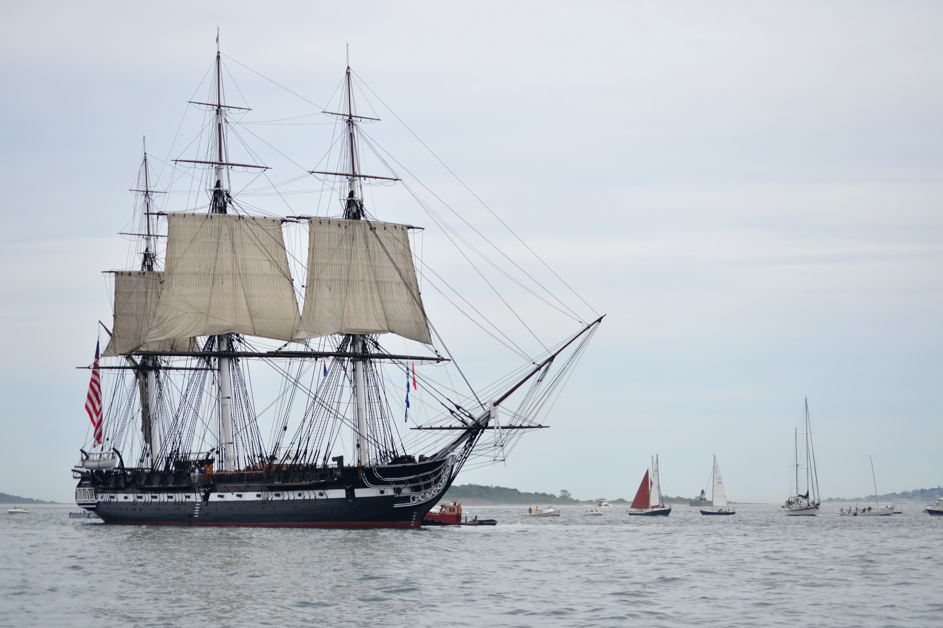
Nearby, at the Charlestown Navy Yard, floats the USS Constitution — "Old Ironsides," launched in 1797 and the oldest commissioned naval vessel still afloat. The ship gets its own full story elsewhere on this site; on the trail, it is the fitting final stop: the war the walk commemorates, embodied in oak and canvas. The red line ends where the Republic's first navy begins.
Walking It Well
You do not need a guide to walk the Freedom Trail — the red line is the guide. Most people start at Boston Common and end in Charlestown, but the route works in reverse, or in pieces; the downtown cluster (Common through Faneuil Hall) makes a satisfying half-day on its own, while the North End and Charlestown are the deeper cut. Budget at least three hours for the full walk, more if you step inside the churches and museums. Spring and fall are the kindest seasons; summer brings the crowds that four million annual visitors imply. Wear real walking shoes — the brick line is unforgiving in fashionable footwear — and remember that the trail is a line through a living city. The best moments often happen just off it: a bakery in the North End, a pint near the Navy Yard, a quiet bench in the Granary.
Key Facts
- The Freedom Trail is a 2.5-mile (4 km) walking route marked by a red-brick and red-painted line, connecting 16 Revolutionary-era historic sites.
- It was conceived by journalist William Schofield in his "Have You Heard" column on March 8, 1951, and adopted by Mayor John B. Hynes the same year; over 40,000 people walked it annually by 1953.
- The red line was added in 1958, the Freedom Trail Foundation was founded in 1964, and Bunker Hill and the USS Constitution joined the route in 1972.
- The 16 official stops: Boston Common, Massachusetts State House, Park Street Church, Granary Burying Ground, King's Chapel and Burying Ground, Benjamin Franklin statue and Boston Latin School, Old Corner Bookstore, Old South Meeting House, Old State House, Boston Massacre site, Faneuil Hall, Paul Revere House, Old North Church, Copp's Hill Burying Ground, USS Constitution, Bunker Hill Monument.
- Boston Common, the trail's start, is America's oldest public park, established in 1634; the Massachusetts State House dome was gilded in 1874 over copper rolled by Paul Revere's foundry.
- The Old South Meeting House hosted the December 16, 1773, meeting that led directly to the Boston Tea Party; the Boston Massacre occurred in front of the Old State House on March 5, 1770.
- The Old North Church's steeple carried the "two if by sea" lantern signal on April 18, 1775; the Paul Revere House (c. 1680) is the oldest building in downtown Boston.
- The Bunker Hill Monument (221 feet, dedicated 1843) commemorates the June 17, 1775, battle fought mainly on Breed's Hill; Lafayette laid its cornerstone in 1825.
Freedom Trail in Photographs