The Hill That Named Itself
Beacon Hill begins with a warning light. In 1634 Boston's settlers raised a beacon on the town's highest summit — a great pole topped with an iron basket, ready to be filled with tar and lit to warn the countryside that invaders were coming. The hill was one of three peaks that gave Boston its first nickname, the Trimount, and for nearly two centuries the beacon defined it. What you walk today, though, is a lowered hill. Beginning in 1807, developers took the summit down by some 60 feet, carting the gravel off to fill the Mill Pond and manufacture new land; Charles Bulfinch's handsome memorial column of 1790, a 60-foot Doric pillar topped by a gilded eagle, came down with the dirt. At the crest stands the replacement landmark: Bulfinch's Massachusetts State House, built 1795–98, its dome sheathed in copper rolled by Paul Revere's foundry, then gilded in 1874, painted drab gray to hide it from wartime bombers, and re-gilded in 23-karat gold leaf in 1997. The building swallowed the neighborhood's name whole — in Boston, “Beacon Hill” also means the state government inside it.
The South Slope: Brahmins, Bulfinch, and Brick
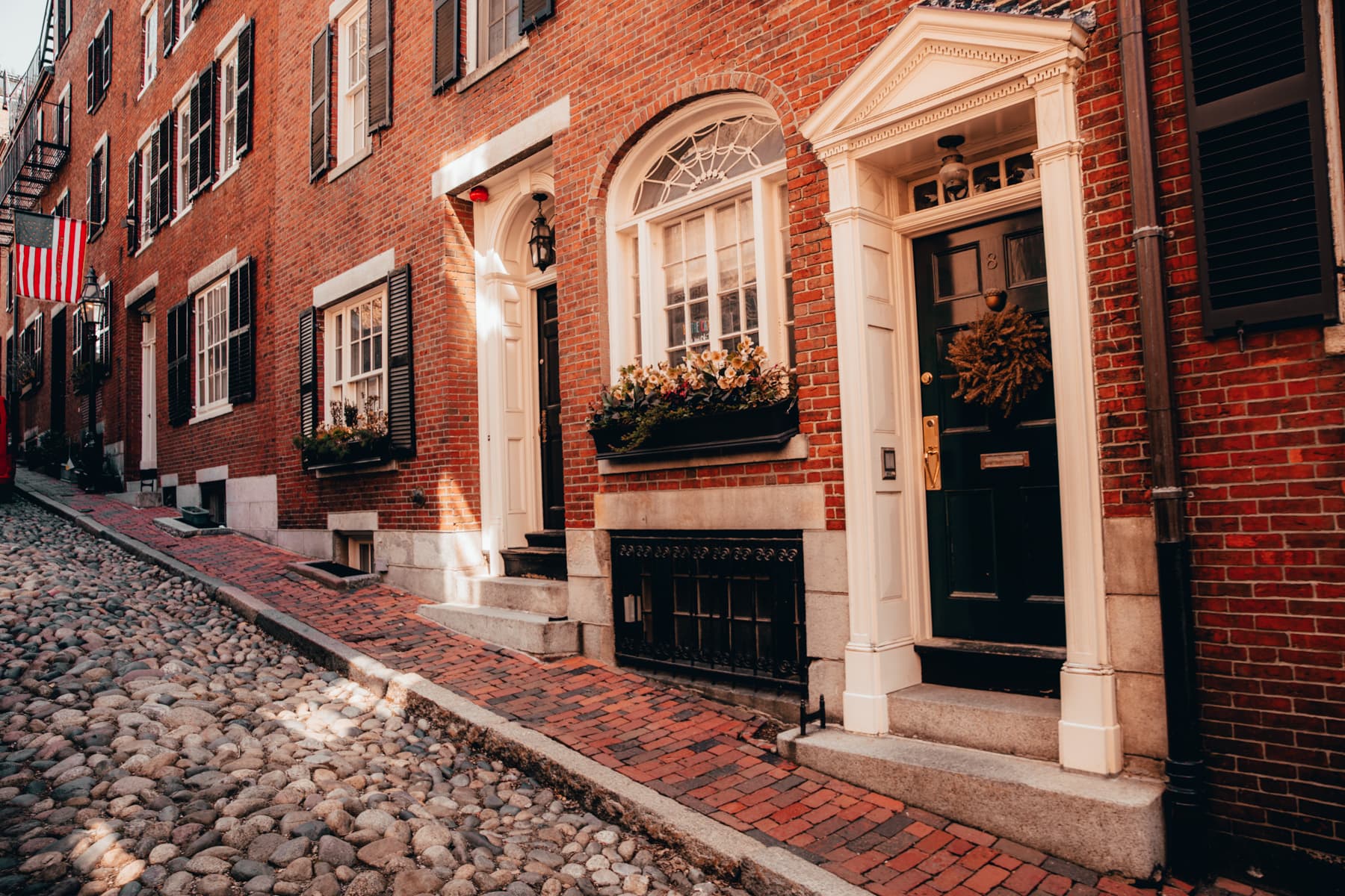
From 1795 the Mount Vernon Proprietors — a syndicate that included developer Harrison Gray Otis — hired Bulfinch to turn the sunny south slope into Boston's most exclusive address, and the Boston Brahmins built accordingly: block after block of Federal and Greek Revival red-brick rowhouses with white trim, ornate ironwork, recessed doorways, and boot scrapers by the steps. Mount Vernon and Chestnut streets remain the showcases, addresses of senators, publishers, and old money for two solid centuries, and the writers followed the money: Louisa May Alcott, Robert Frost, and Sylvia Plath all lived on the hill at various times. The south slope's beloved defect is in its windows. A shipment of glass imported in the early 1800s carried excess manganese, and decades of sunlight slowly oxidized pane after pane into lavender and amethyst. Homeowners were furious — until the purple panes became so rare and recognizable that they turned into heirlooms, a defect you now brag about. Spotting one is the neighborhood's favorite scavenger hunt.
Acorn Street and Louisburg Square
Two spots carry the neighborhood's fame. Acorn Street, laid out in the 1820s and paved with genuine river cobbles, is a single narrow lane of modest brick houses built not for Brahmins but for their coachmen, cooks, and artisans — working housing tucked behind the mansions it served. The scale is exactly why photographers adore it: flower boxes, gas lamps, flags, and not one straight sightline, and it is routinely called the most photographed street in America. It is also still a public street and still somebody's front step, a combination that demands dawn visits and quiet voices. A few minutes west sits Louisburg Square (pronounced Lewis-burg), the hill's inner sanctum: a private, fence-enclosed green owned collectively by the surrounding homeowners since the 1840s, flanked by statues of Christopher Columbus and Aristides the Just. Louisa May Alcott spent her last years at No. 10, and parking around the square is reserved for its residents — drive in without a claim and the city will happily ticket you. On Christmas Eve, carolers and handbell ringers gather under the lamps, a tradition residents have kept for generations.
The North Slope: The Black Heritage Trail
Cross Myrtle Street and the same hill tells America's other foundational story. The shadier north slope was where the hill's servants, laborers, and immigrants lived — and through the 1800s it held one of the largest free Black communities in the young United States, more than 2,000 people by 1860, building institutions a generation before emancipation. On Smith Court stands the African Meeting House of 1806, the oldest surviving Black church building in the country, where William Lloyd Garrison founded the New England Anti-Slavery Society in 1832; beside it, the Abiel Smith School (1835) was the first public schoolhouse built for Black children in America. Lewis and Harriet Hayden's house at 66 Phillips Street was the city's most famous Underground Railroad station — Hayden, himself escaped from slavery, kept it stocked and defended. Antislavery senator Charles Sumner lived at 20 Hancock Street, and the community fought Boston's own school battle: after the Roberts case challenged segregated classrooms in 1850, Massachusetts banned them in 1855, and the Phillips School on Pinckney Street became one of the city's first integrated schools. These stops form the Black Heritage Trail, a 1.6-mile, 14-site walk run with the National Park Service and the Museum of African American History, which ends across from the State House at Saint-Gaudens' Robert Gould Shaw and 54th Regiment Memorial — the monument to the Civil War's first Black regiment, recruited from this very community.
Still Lit by Gas
The detail everyone photographs without thinking about it is the light. Boston maintains roughly 2,800 working gas lamps, and more than 1,000 of them burn on Beacon Hill — the largest concentration in the city — in daylight as in dark, because that is how gas mantles work. The twist: the flames are not survivors but a revival. Boston had electrified every streetlight by 1913, and only in the 1960s did the city deliberately put gas back into its historic districts as an act of preservation. In recent years the lamps have become a climate argument — a few percent of the city's lights producing an outsized share of street-lighting emissions — and the city has studied LED retrofits hidden inside the historic fixtures, while the Public Works department has said there are no plans to replace the Hill's lamps. Residents, who successfully defended their brick sidewalks against concrete in the last decade and live under the rules of Massachusetts' first local historic district (1955), are unlikely to let the flames go quietly.
Walking the Hill
Walk it top-down and let gravity help. Start at Park Street station — the first subway station in America, opened 1897 — climb to the State House steps, and take Beacon Street west to Mount Vernon Street. The Freedom Trail's red line hugs the hill's foot along Beacon and Tremont streets, so the statehouse steps double as a trail stop, with Park Street Church and the Granary Burying Ground a block east. Follow Mount Vernon to Louisburg Square, drop down to Acorn Street for the cobbles, then descend to Charles Street, the flat commercial spine of antiques shops and cafés at the hill's foot. Recross east on Myrtle or Revere Street and finish on the north slope: Joy Street to Smith Court for the African Meeting House and the Smith School, then Pinckney Street back down to Charles/MGH station. Cobbles and brick are honest about their age — wear flat shoes, expect the Acorn Street stones to punish heels, and plan on an hour minimum, two if the trail's plaques catch you. The lamps switch the neighborhood from handsome to magical at dusk, and in May the Beacon Hill Garden Club opens the hidden gardens behind the fences for its annual tour, a tradition running since 1929. Whatever you do, come on foot or by T: between the resident-permit signs and the square's private claims, Beacon Hill is a neighborhood that has been politely refusing cars for two hundred years.
Key Facts
Named for the warning beacon raised on the summit in 1634, when the hill was one of the three peaks of Boston's “Trimount”; the summit was later cut down about 60 feet to fill the Mill Pond.
Crowned by the Massachusetts State House (1795–98, designed by Charles Bulfinch), whose dome — copper from Paul Revere's foundry — was gilded in 1874 and re-gilded in 23-karat gold leaf in 1997; “Beacon Hill” is also Boston slang for the state government.
Acorn Street, an 1820s lane paved with river cobbles and lined with the houses of coachmen and artisans, is often called the most photographed street in America.
Louisburg Square's central green is privately owned by the surrounding homeowners, who have held it collectively since the 1840s; parking around the square is reserved to them, and Louisa May Alcott lived at No. 10.
The north slope holds the Black Heritage Trail: 1.6 miles and 14 sites, including the African Meeting House (1806, the nation's oldest surviving Black church) and the Abiel Smith School (1835), starting point of Boston's free Black community.
Boston keeps about 2,800 gas street lamps, over 1,000 of them on Beacon Hill — lamps that were actually reinstalled by the city in the 1960s as historic preservation after Boston went fully electric in 1913.
Visitor Details
Address: Beacon Hill, Boston, MA — roughly bounded by Cambridge Street, Bowdoin Street, Boston Common, and the Charles River. Anchor point: the Massachusetts State House, 24 Beacon Street.
Transit: Park Street (Red/Green Lines), Charles/MGH (Red Line), Bowdoin (Blue Line) and Government Center all border the hill. Do not plan to drive: nearly every curb is resident-permit parking, tightly enforced, and the nearest garages (Boston Common, Government Center) are the fallback, not the plan.
Hours/Admission: The neighborhood itself is public streets — open around the clock and free. Interiors are private homes. The African Meeting House and Abiel Smith School are run by the Museum of African American History, which keeps its own hours and ticket prices (check maah.org); National Park Service ranger-led Black Heritage Trail tours have run seasonally and are free (check nps.gov/boaf for current schedules). Free guided State House tours run on weekdays through the Secretary of the Commonwealth's office (check sec.state.ma.us).
Best timing: Come at dawn for an empty, lamplit Acorn Street, or at dusk when the gas lamps take over and the bricks go amber. May brings the Beacon Hill Garden Club's Hidden Gardens tour (ticketed, one day, sells out — see the club's site); December wraps the hill in wreaths and candlelit windows, with Christmas Eve caroling at Louisburg Square. In winter, ice on the cobbles is real — flat, grippy shoes are not a suggestion.
Beacon Hill in Pictures